 view gallery view gallery NE0.2 km NE0.2 km
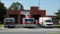
|   R.C. Brock Fire Hall R.C. Brock Fire Hall
in Firehouses Corunna Fire Department posted by:  Jay Walking Jay Walking location: Ontario, Canada date approved: 05/10/2007 last visited: 03/23/2012 |
 view gallery view gallery NW1.6 km NW1.6 km
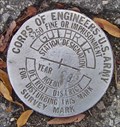
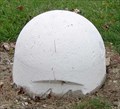
|  US Army BM - Guthrie US Army BM - Guthrie
in Canadian Benchmarks A well preserved BM placed in 1981 by the US Army Corps of Engineers on the Canadian side of the St Clair River south of Sarnia, Ontario posted by:  Hard Oiler Hard Oiler location: Ontario, Canada date approved: 11/14/2005 last visited: 08/02/2009 |
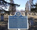
  N2.1 km N2.1 km
| IBC 48-42 in Canadian Benchmarks IBC Marker 48 (IBC19994842) is one of the land based International Boundary Commission markers used to define the US/Canada border along the St Clair River between Michigan and Ontario posted by: Hard Oiler location: Ontario, Canada date approved: 03/19/2006 last visited: 03/01/2019 |
 view gallery view galleryN2.1 km |  The International Boundary The International Boundary
in Ontario Provincial Plaques This plaque recognizes the surveys carried out to define the boundary between Canada and the United States. posted by: Hard Oiler location: Ontario, Canada date approved: 03/08/2006 last visited: 05/17/2009 |
 view gallery view galleryN2.1 km | IBC Marker 48 in Canadian Benchmarks IBC Marker 48 is one of the land based International Boundary Commission markers used to define the US/Canada border along the St Clair River between Michigan and Ontario posted by: TnT location: Ontario, Canada date approved: 11/22/2005 last visited: 08/02/2009 |
 view gallery view galleryNW2.3 km |  City of Marysville Dog Park - Marysville,MI City of Marysville Dog Park - Marysville,MI
in Off-Leash Dog Areas Fenced in off-leash dog park in Marysville, Michigan. posted by: bobfrapples8 location: Michigan date approved: 07/05/2022 last visited: never |
 view gallery view galleryN2.6 km | "FROOME AND FIELD TALFOURD" in Ontario Provincial Plaques This plaque marks the founding of Froomefield, one of the first settlements on the St. Clair river, by Froome and Field Talfourd in 1836. posted by: Hard Oiler location: Ontario, Canada date approved: 03/24/2006 last visited: 06/07/2020 |
 view gallery view galleryNW2.9 km |  Marysville Municipal Park - Marysville, MI Marysville Municipal Park - Marysville, MI
in Peace Poles Peace Pole located in Marysville Municipal Park in Marysville, Michigan. posted by: bobfrapples8 location: Michigan date approved: 08/29/2022 last visited: never |
 view gallery view galleryNW2.9 km |  C. H. Wills & Company C. H. Wills & Company
in Michigan Historical Markers Located on the south side of East Huron Boulevard, about 0.1 mile east of Busha Highway. Parking available at the Marysville Museum and park across East Huron Boulevard. posted by: S5280ft location: Michigan date approved: 10/23/2006 last visited: 07/06/2022 |
 view gallery view galleryNW3.1 km |  Detroit Edison #203 - Marysville, MI Detroit Edison #203 - Marysville, MI
in Locomotives Built by Baldwin in 1923, this 0-6-0 steam engine shunted coal cars for Detroit Edison’s massive Marysville power plant for over 30 years. posted by: hykesj location: Michigan date approved: 06/14/2023 last visited: never |
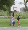 view gallery view galleryNW3.1 km |  Marysville City Park - Marysville, Michigan Marysville City Park - Marysville, Michigan
in Outdoor Basketball Courts Located east of Busha Highway on East Huron Boulevard. posted by: S5280ft location: Michigan date approved: 09/14/2007 last visited: 05/05/2013 |
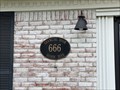 view gallery view galleryNW4.2 km |  666 Huron Blvd. - Marysville, MI 666 Huron Blvd. - Marysville, MI
in 666 Sightings The Changing Room is at 66 Huron Boulevard in Marysville, Michigan. posted by: bobfrapples8 location: Michigan date approved: 07/09/2022 last visited: never |
 view gallery view galleryNW4.2 km |  Marysville Veterninary Clinic - Marysville, MI Marysville Veterninary Clinic - Marysville, MI
in Time and Temperature Signs Time and temperature sign located at a veterinary clinic in Marysville, Michigan. posted by: bobfrapples8 location: Michigan date approved: 12/30/2022 last visited: never |
 view gallery view galleryNW4.2 km |  Tim Horton's - Marysville, MI Tim Horton's - Marysville, MI
in Tim Horton's Restaurants Tim Horton's in Marysville, Michigan posted by: ChileHead location: Michigan date approved: 10/19/2009 last visited: 06/02/2021 |
 view gallery view galleryNW4.3 km |  Subway - Gratiot Blvd. - Marysville, MI Subway - Gratiot Blvd. - Marysville, MI
in Subway Restaurants Subway restaurant on Gratiot in Marysville, Michigan. posted by: bobfrapples8 location: Michigan date approved: 05/10/2023 last visited: never |
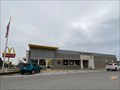 view gallery view galleryNW4.3 km |  McDonald's - Gratiot Blvd. - Marysville, MI McDonald's - Gratiot Blvd. - Marysville, MI
in McDonald's Restaurants McDonald's located in Marysville, Michigan. posted by: bobfrapples8 location: Michigan date approved: 01/04/2023 last visited: never |
 view gallery view galleryN5 km | 693741: Topographical Survey Division Marker, Sarnia in Canadian Benchmarks A first order benchmark placed by the Topographical Survey Division of NRC in 1969 located south of Sarnia, Ontario opposite the Sunoco refinery. posted by: Hard Oiler location: Ontario, Canada date approved: 11/14/2005 last visited: 08/09/2009 |
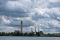 view gallery view galleryN5.5 km |  Sarnia Regional Cogeneration Plant - Sarnia, Ontario Sarnia Regional Cogeneration Plant - Sarnia, Ontario
in Wikipedia Entries Natural gas cogeneration plant located across the St. Clair River from Port Huron in Sarnia, Ontario. posted by: bobfrapples8 location: Ontario, Canada date approved: 07/21/2022 last visited: never |
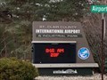 view gallery view gallery W6.3 km W6.3 km
| St. Clair County Airport and Industrial Park -St. Clair, MI in Time and Temperature Signs Time and temperature sign located at the access road to the St. Clair County Airport. posted by: bobfrapples8 location: Michigan date approved: 12/27/2022 last visited: never |
 view gallery view galleryN6.3 km |  Establishment of the Polymer Corporation Establishment of the Polymer Corporation
in Canadian National Historic Sites The establishment of the Polymer Corporation in 1942 to manufacture synthetic rubber allowed Canada to gain a significant foothold in the important field of polymer chemistry. posted by: Hard Oiler location: Ontario, Canada date approved: 04/06/2006 last visited: 05/17/2009 |
 view gallery view galleryN6.8 km | Shiloh Baptist Church in Michigan Historical Markers Located on the northwest corner of and 28th and Nern Streets. Streetside parking available. posted by: S5280ft location: Michigan date approved: 10/23/2006 last visited: 12/16/2022 |
 view gallery view galleryN6.8 km |  Port Huron’s historic Shiloh Missionary Baptist Church is alive with stories to tell - Port Huron, MI Port Huron’s historic Shiloh Missionary Baptist Church is alive with stories to tell - Port Huron, MI
in News Article Locations News article about the history of the Shiloh Baptist Church in Port Huron, Michigan. posted by: bobfrapples8 location: Michigan date approved: 12/16/2022 last visited: never |
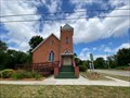
 view gallery view gallery S6.9 km S6.9 km
| Sutherland’s Landing in Ontario Provincial Plaques This plaque marks the location of the first Anglican Church in the community of Sutherland’s Landing on the St Clair river. posted by: Hard Oiler location: Ontario, Canada date approved: 03/24/2006 last visited: never |
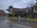 view gallery view gallery SW7.4 km SW7.4 km
| St. Clair Inn in Michigan Historical Markers Located on the east side of North Riverside Avenue, just north of Vine Street. It's the first marker I've seen with valet parking. posted by: S5280ft location: Michigan date approved: 10/23/2006 last visited: 07/06/2022 |
 view gallery view galleryS7.4 km | 24U3256 - MMMCCLVI - IBC Marker 44 in Canadian Benchmarks IBC Marker 44 is one of the land based International Boundary Commission markers once used to define the US/Canada border along the St Clair River between Michigan and Ontario posted by: Hard Oiler location: Ontario, Canada date approved: 11/02/2005 last visited: 08/09/2009 |
|