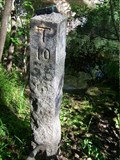
 view gallery view gallery SW2.9 km SW2.9 km
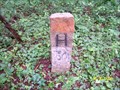
|   4858 (MADPW, Georgetown, MA) 4858 (MADPW, Georgetown, MA)
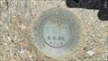
in U.S. Benchmarks A MADPW standard bench mark disk, located in Georgetown, MA.
The MHD ID# is 15546. posted by:  NH2beers NH2beers location: Massachusetts date approved: 06/30/2011 last visited: never |
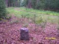
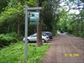
 view gallery view gallery N3.7 km N3.7 km
| 4862 (MADPW, Byfield, MA) in U.S. Benchmarks A MADPW standard bench mark disk, located in Byfield, MA.
The MHD ID# is 15925. posted by: NH2beers location: Massachusetts date approved: 06/30/2011 last visited: never |
 view gallery view gallery E4.3 km E4.3 km
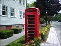
|  Red Telephone Box Rowley, MA USA Red Telephone Box Rowley, MA USA
in Red Telephone Boxes Red Telephone Box off Summer Road in Rowley, MA, USA posted by:  WiiGeo WiiGeo location: Massachusetts date approved: 06/29/2010 last visited: 11/10/2015 |
 view gallery view galleryE4.7 km |  Town Hall Clock - Rowley MA Town Hall Clock - Rowley MA
in Town Clocks Located at 139 Main Street, Rowley, MA? posted by: nomadwillie location: Massachusetts date approved: 06/12/2010 last visited: 07/18/2017 |
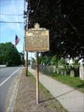 view gallery view galleryE4.7 km |  Rowley Burial Ground - Rowley MA Rowley Burial Ground - Rowley MA
in Massachusetts Historical Markers Located on Main Street next to the Town Hall. posted by: nomadwillie location: Massachusetts date approved: 06/15/2010 last visited: 07/18/2017 |
 view gallery view galleryE4.7 km |  Rowley, MA Rowley, MA
in City and Town Halls Located at 139 Main Street, Rowley, MA posted by: nomadwillie location: Massachusetts date approved: 06/15/2010 last visited: 07/18/2017 |
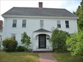 view gallery view galleryE4.7 km |  Lambert, Thomas, House - Rowley MA Lambert, Thomas, House - Rowley MA
in U.S. National Register of Historic Places Located at 142 Main St in Rowley MA posted by: nomadwillie location: Massachusetts date approved: 06/13/2010 last visited: 07/18/2017 |
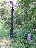
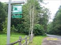
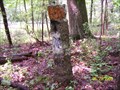
 view gallery view gallerySW4.7 km |  Boxford-Georgetown-Rowley (B-G-R) Boxford-Georgetown-Rowley (B-G-R)
in U.S. Historic Survey Stones and Monuments A granite post marking the three way junction point of the boundary lines between the towns of Boxford, Georgetown, and Rowley, all in Essex County, Massachusetts. It is located in the Georgetown-Rowley State Forest. posted by: bctrail location: Massachusetts date approved: 10/27/2010 last visited: never |
 view gallery view gallerySW5.5 km | 4855 (MADPW, Boxford, MA) in U.S. Benchmarks A MADPW standard bench mark disk, located in Boxford, MA.
The MHD ID# is 15543. posted by: NH2beers location: Massachusetts date approved: 06/30/2011 last visited: never |
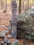
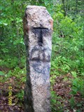
 view gallery view gallery S7.2 km S7.2 km
|  Ipswich-Topsfield #10 (IT-10) Ipswich-Topsfield #10 (IT-10)
in Public Land Survey Marks A granite post marking one point on the boundary line between the towns of Ipswich and Topsfield, Massachusetts. It is located in Willowdale State Forest.. posted by: bctrail location: Massachusetts date approved: 07/19/2009 last visited: never |
 view gallery view gallery SE7.6 km SE7.6 km
|  Dairy Queen - Ipswich, MA Dairy Queen - Ipswich, MA
in Dairy Queen Restaurants This stand-alone DQ is located along scenic Route 1A in Ipswich, Massachusetts. posted by: silverquill location: Massachusetts date approved: 11/02/2014 last visited: never |
 view gallery view galleryS7.6 km | Ipswich-Topsfield 1 (I-T1) in Public Land Survey Marks A granite post marking one point on the boundary line between the towns of Ipswich and Topsfield, Massachusetts. It is located on the Topsfield/Ipswich Road. posted by: bctrail location: Massachusetts date approved: 07/19/2009 last visited: never |
 view gallery view galleryS7.6 km | Hamilton-Ipswich-Topsfield (H-I-T) in Public Land Survey Marks A granite post marking the three way junction point of the boundry lines between the towns of Hamilton, Ipswich, and Topsfield, Massachusetts. It is located in Bradley Palmer State Park posted by: bctrail location: Massachusetts date approved: 07/03/2010 last visited: 09/01/2012 |
 view gallery view galleryS7.6 km |  Willowdale Meadow Willowdale Meadow
in Public Access Lands Located in Topsfield, Massachusetts, and surrounded by Willowdale State Forest, this 8.7 acre parcel, now conserved, was the last remaining buildable parcel in the area. posted by: bctrail location: Massachusetts date approved: 07/17/2009 last visited: 08/30/2016 |
 view gallery view galleryS7.6 km | Hamilton-Topsfield 1 WM (HT-1 WM) in Public Land Survey Marks A granite post marking one point on the boundary line between the towns of Hamilton and Topsfield, Massachusetts. It is located in Bradley Palmer State Park. posted by: bctrail location: Massachusetts date approved: 07/06/2009 last visited: never |
 view gallery view gallerySE7.9 km |  Foote Brothers Canoe Rentals, Ipswich, Massachusetts Foote Brothers Canoe Rentals, Ipswich, Massachusetts
in Outdoor Recreation Stores A thriving rental business on a beautiful spot on the Ipswich River. posted by: bctrail location: Massachusetts date approved: 07/16/2010 last visited: 08/30/2016 |
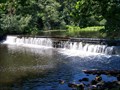 view gallery view gallerySE7.9 km |  Waterfall at Willowdale Dam Waterfall at Willowdale Dam
in Man-made Waterfalls This Ipswich River dam and waterfall is in remarkably good condition at age 175. posted by: bctrail location: Massachusetts date approved: 07/09/2010 last visited: 08/30/2016 |
 view gallery view gallerySE7.9 km |  Willowdale Mill Dam Willowdale Mill Dam
in Water Dams Built ca 1830, this dam is now a local scenic attraction. posted by: bctrail location: Massachusetts date approved: 07/23/2010 last visited: 08/30/2016 |
 view gallery view galleryS8 km |  Bradley Palmer State Park, Topsfield and Hamilton, MA Bradley Palmer State Park, Topsfield and Hamilton, MA
in State/Provincial Parks This 721-acre former estate provides recreation for adults and kids of all ages. It features miles of serene forest trails, acres of meadows and spectacular rhododendrons. posted by: bctrail location: Massachusetts date approved: 07/07/2009 last visited: 08/30/2016 |
 view gallery view gallerySE8.2 km |  Willowdale Mill Site Willowdale Mill Site
in Water Mills On a 25 acre protected property in Hamilton, Massachusetts, this was the site of a factory making woolen goods from ca 1830 to 1884, and powered by the Ipswich River. Only the dam, sluiceway, and a cellar hole remain. posted by: bctrail location: Massachusetts date approved: 07/04/2010 last visited: 08/30/2016 |
 view gallery view gallerySE8.2 km | Willowdale Mill Reservation in Public Access Lands A 25 acre property in Hamilton, Massachusetts, the site of a factory making woolen goods from ca 1830 to 1884, and powered by the Ipswich River. Only the dam, sluiceway, and a cellar hole remain. posted by: bctrail location: Massachusetts date approved: 07/17/2009 last visited: 08/30/2016 |
 view gallery view galleryS8.4 km | Hamilton-Topsfield #02 (HT-02) in Public Land Survey Marks A granite post marking one point on the boundary line between the towns of Hamilton and Topsfield, Massachusetts. It is located in Bradley Palmer State Park. posted by: bctrail location: Massachusetts date approved: 06/29/2009 last visited: never |
 view gallery view galleryS8.4 km | Hamilton-Topsfield #03 (HT-03) in Public Land Survey Marks A granite post marking one point on the boundary line between the towns of Hamilton and Topsfield, Massachusetts. It is located in Bradley Palmer State Park. posted by: bctrail location: Massachusetts date approved: 06/30/2009 last visited: never |
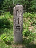 view gallery view galleryS8.5 km |  Danvers-Newburyport railroad, B25N15 Danvers-Newburyport railroad, B25N15
in Milestones A concrete post indicating 25 miles to Boston and 15 miles to Newburyport on the abandon RR route. The rails and sleepers are long gone, and an electric power line now uses the right-of-way. posted by: bctrail location: Massachusetts date approved: 06/18/2011 last visited: never |
 view gallery view gallerySE8.7 km |  Lord Square - Ipswich MA Lord Square - Ipswich MA
in Dunkin Donuts' Located at 1 Lord Square, Ipswich, MA? posted by: nomadwillie location: Massachusetts date approved: 06/14/2010 last visited: 05/30/2010 |
|