 view gallery view gallery E5 km E5 km
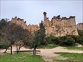
|   Les Orgues - Ille-sur-Têt (Pyrénées-Orientales), France Les Orgues - Ille-sur-Têt (Pyrénées-Orientales), France
in Places of Geologic Significance [FR] Les Orgues d'Ille-sur-Têt sont des cheminées de fée résultent de l'érosion de roches sédimentaires vieilles de quatre millions d'années. [EN] An exceptional landscape of astonishing natural structures: the "fairy chimneys". posted by:  RakeInTheCache RakeInTheCache location: Occitanie, France date approved: 05/16/2022 last visited: never |
 view gallery view gallery NW8.5 km NW8.5 km
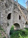
|  Pont-aqueduc - Ansignan (Pyrénées-Orientales), France Pont-aqueduc - Ansignan (Pyrénées-Orientales), France
in Ancient Roman Civilization [FR] L'aqueduc romain d'Ansignan se trouve au Nord du village d'Ansignan. [EN] The bridge aqueduct in Ansignan is an excellent example of the Roman influence on the Agly valley. The foundations of the construction date back to 300 AD. posted by: RakeInTheCache location: Occitanie, France date approved: 05/19/2022 last visited: never |
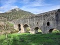 view gallery view galleryNW8.5 km |  Pont-aqueduc - Ansignan (Pyrénées-Orientales), France Pont-aqueduc - Ansignan (Pyrénées-Orientales), France
in Ancient Aqueducts [FR] Le pont-aqueduc d’Ansignan aurait été érigé entre 220 et 270 puis rénové au fil des siècles notamment au XIIIe siècle. [EN] The aqueduct bridge of Ansignan is built on the base of a Roman (viaduct) bridge, perhaps in the third century CE. posted by: RakeInTheCache location: Occitanie, France date approved: 05/23/2022 last visited: never |
 view gallery view gallery S10.9 km S10.9 km
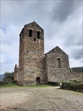
|  Prieuré de Serrabona - Boule d'Amont (Pyrénées-Orientales) - France Prieuré de Serrabona - Boule d'Amont (Pyrénées-Orientales) - France
in Romanesque Architecture [FR] Fondé au XI° siècle, le Prieuré de Serrabona est un chef d’œuvre de l’art roman. [EN] Serrabone Priory is famous for its splendid marble rostrum from the 12th century, regarded as a masterpiece of Romanesque art. posted by: RakeInTheCache location: Occitanie, France date approved: 05/16/2022 last visited: never |
 view gallery view gallery N12.9 km N12.9 km
|  La Gare Le Train Rouge - Maury - France -155.32 meters La Gare Le Train Rouge - Maury - France -155.32 meters
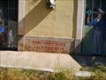
in Elevation Signs Elevation sign on the wal of trainstation Maury posted by: superstein location: Occitanie, France date approved: 11/28/2022 last visited: never |
 view gallery view gallery SW14.2 km SW14.2 km
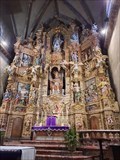
|  Retable de l'Église Saint-Pierre - Prades (Pyrénées-Orientales), France Retable de l'Église Saint-Pierre - Prades (Pyrénées-Orientales), France
in Wooden Church Artefacts [FR] Le grand retable du maître-autel est une commande en 1696 à un jeune catalan, Joseph Sunyer [EN] The masterpiece of this church is the main altarpiece. Pearl of the Spanish baroque art from the 17th century. posted by: RakeInTheCache location: Occitanie, France date approved: 05/15/2022 last visited: never |
 view gallery view gallery NE14.5 km NE14.5 km
| Gare d'Estagel - Estagel - France - 81.55 meters in Elevation Signs Elevation sign on the wal of trainstation Estagel posted by: superstein location: Occitanie, France date approved: 11/30/2022 last visited: never |
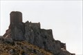
 view gallery view galleryN16.4 km |  Château de Quéribus - Cucugnan, France Château de Quéribus - Cucugnan, France
in Satellite Imagery Oddities [EN] The castle of Quéribus is a castle called "cathare" located in the commune of Cucugnan in the department of Aude.
[FR] Le château de Quéribus est un château dit « cathare » situé sur la commune de Cucugnan dans le département de l'Aude. posted by: pmaupin location: Occitanie, France date approved: 03/13/2017 last visited: 08/20/2010 |
 view gallery view galleryN16.4 km |  Le Château de Quéribus - Cucugnan - Aude - France Le Château de Quéribus - Cucugnan - Aude - France
in Monuments Historiques Français [FR] Le château de Quéribus est un château dit « cathare » situé sur la commune de Cucugnan dans le département de l'Aude.
[EN] The castle of Quéribus is a castle called "cathare" located in the commune of Cucugnan in the department of Aude. posted by: pmaupin location: Occitanie, France date approved: 11/20/2016 last visited: 07/31/2015 |
 view gallery view galleryN16.4 km |  Château de Quéribus - Cucugnan - Aude - France Château de Quéribus - Cucugnan - Aude - France
in Castles [EN] The castle of Quéribus is a castle called "cathare" located in the commune of Cucugnan in the department of Aude.
[FR] Le château de Quéribus est un château dit « cathare » situé sur la commune de Cucugnan dans le département de l'Aude. posted by: pmaupin location: Occitanie, France date approved: 11/20/2016 last visited: 07/31/2015 |
 view gallery view galleryN16.4 km |  Château de Quéribus - Cucugnan, France Château de Quéribus - Cucugnan, France
in Wikipedia Entries [EN] The castle of Quéribus is a castle called "cathare" located in the commune of Cucugnan in the department of Aude.
[FR] Le château de Quéribus est un château dit « cathare » situé sur la commune de Cucugnan dans le département de l'Aude. posted by: pmaupin location: Occitanie, France date approved: 03/13/2017 last visited: 08/20/2010 |
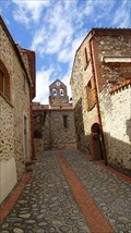
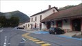 view gallery view gallerySW19.5 km |  Villefranche-de-Conflent - France Villefranche-de-Conflent - France
in Train Stations/Depots Villefranche - Vernet-les-Bains station is a French railway station located in Fuilla, in the Pyrénées-Orientales department, in the Occitanie region. posted by: superstein location: Occitanie, France date approved: 02/19/2022 last visited: never |
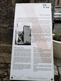
 view gallery view gallerySW20 km |  Vous Etes Ici - Villefranche de Conflent, France Vous Etes Ici - Villefranche de Conflent, France
in 'You Are Here' Maps Your position in the centre of the village posted by: g300td location: Occitanie, France date approved: 12/12/2014 last visited: never |
 view gallery view gallerySW20 km |  Villefranche-de-Conflent - France Villefranche-de-Conflent - France
in Bell Towers Villefranche-de-Conflent is located in the canton of Les Pyrénées catalanes and in the arrondissement of Prades. posted by: superstein location: Occitanie, France date approved: 10/20/2021 last visited: never |
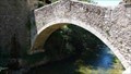 view gallery view gallerySW20 km |  Arch Bridge in Villefranche de Conflent, France Arch Bridge in Villefranche de Conflent, France
in Arch Bridges This arch bridge is situated in a World Heritage Site posted by: g300td location: Occitanie, France date approved: 12/11/2014 last visited: 09/10/2018 |
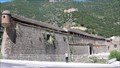 view gallery view gallerySW20.1 km |  Fortifications of Vauban (VILLEFRANCHE-DE-CONFLENT) - France Fortifications of Vauban (VILLEFRANCHE-DE-CONFLENT) - France
in World Heritage Sites The original town dates from 1098 posted by: g300td location: Occitanie, France date approved: 12/12/2014 last visited: 05/18/2022 |
 view gallery view gallerySW20.1 km | Villefranche-de-Conflent - France in Wikipedia Entries The original town dates from 1098 posted by: g300td location: Occitanie, France date approved: 12/11/2014 last visited: 09/10/2018 |
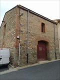 view gallery view galleryE23 km |  Canoës, Pyrénées-Orientales, France Canoës, Pyrénées-Orientales, France
in Cobblestone Buildings [Fr]une maison traditionnelle occitane est construit avec des galets sur ses façades.
[En] Traditional housse with cobblestone on its façades. posted by: Tromel location: Occitanie, France date approved: 05/04/2022 last visited: 05/04/2022 |
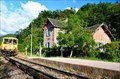 view gallery view gallerySW24.1 km | Serdinya - Pyrénées-Orientales - France in Train Stations/Depots Station on the, still active, world famous Yellow Train tourist railway. posted by: superstein location: Occitanie, France date approved: 02/28/2022 last visited: never |
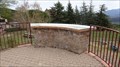 view gallery view galleryS24.8 km |  Table d'orientation Montbolo - France Table d'orientation Montbolo - France
in Orientation Tables Orientation Table in a small park of the town of Montbol0 posted by: superstein location: Occitanie, France date approved: 05/21/2023 last visited: never |
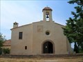 view gallery view gallery SE24.9 km SE24.9 km
|  St Ferréol Hermitage, Céret, France St Ferréol Hermitage, Céret, France
in Medieval Churches The St Ferréol Hermitage is a simple chapel built in the XIII century on the side of Mt Canigou, above the town of Céret, France. Here are the relics of St Ferréol, a martyr in 304. posted by:  arby101ca arby101ca location: France date approved: 04/28/2010 last visited: never |
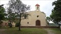 view gallery view gallerySE24.9 km |  Hermitage Saint-Ferréol de Céret - France Hermitage Saint-Ferréol de Céret - France
in This Old Church The Ermitage Saint-Ferréol (in Catalan and on the IGN map: Sant Ferriol) is a chapel dedicated to Saint Ferréol in Céret (Pyrénées-Orientales). Built in the XIII th century on pre-Romanesque bases, it was rebuilt in the XVIII th century. posted by: superstein location: Occitanie, France date approved: 02/18/2022 last visited: never |
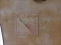 view gallery view gallerySE24.9 km |  Ermitage Sant Ferriol, near Ceret, Languedoc-Roussillon, France Ermitage Sant Ferriol, near Ceret, Languedoc-Roussillon, France
in Sundials The Hermitage of St Ferreol is 5 kms North East of Ceret on the river Tech. 300m altitude. posted by: GeoRams location: Occitanie, France date approved: 10/11/2014 last visited: never |
 view gallery view gallerySE24.9 km |  Sant Miquel de Vivers. - France Sant Miquel de Vivers. - France
in Town Clocks Clock in the tower of Sant Miquel de Vivers. posted by: superstein location: Occitanie, France date approved: 05/18/2023 last visited: never |
 view gallery view gallerySE24.9 km | Sant Miquel de Vivers - Vivers - France in Roman Catholic Churches Sant Miquel de Vivers is the parochial church of Poble Rossellonès de Vivers, in North Catalonia. It is located in the center and highest point of the hill where the town is located, next to the place where the Castell de Vivers used to be posted by: superstein location: Occitanie, France date approved: 05/23/2023 last visited: never |
|