 view gallery view gallery E8.5 km E8.5 km
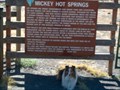
|   Mickey Hot Springs Mickey Hot Springs
in Hot Springs Did you know that Oregon has a mini Yellowstone northeast of the Alvord desert? Me either. BLM has it developed just a little bit with an interpretive sign and some fencing. You can walk around here, carefully, and see steam vents, boiling mud pots and a neat, deep, blue, morning glory pool. Don’t take a dip as it will scald you at over 200 F. There are no boardwalks like at Yellowstone so step carefully. posted by:  JLJL JLJL location: Oregon date approved: 09/07/2005 last visited: never |
 view gallery view gallery W9.5 km W9.5 km
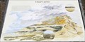
|  Layers of Lava, Blocks of Basalt Layers of Lava, Blocks of Basalt
in Oregon Historical Markers History sign about the geology of Steens Mountain. The sign located off the Steens Mountain Loop Road at the Steens Mountain VP. posted by: Volcanoguy location: Oregon date approved: 03/07/2011 last visited: 08/13/2011 |
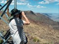
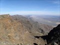 view gallery view galleryW9.5 km |  Steens Mountain Viewpoint Steens Mountain Viewpoint
in Scenic Roadside Look-Outs The Steens Mountain VP along the Steens Mountain Loop Road. posted by: Volcanoguy location: Oregon date approved: 03/05/2011 last visited: 09/02/2007 |
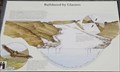
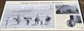
 view gallery view galleryW9.5 km |  Vegetative Zones - Steens Mountain VP, Oregon Vegetative Zones - Steens Mountain VP, Oregon
in Flora and Fauna Information Signs Flora and Fauna Sign at Steens Mountain Viewpoint just off the highest point on the Steens Mountain Loop Road. posted by: Volcanoguy location: Oregon date approved: 03/05/2011 last visited: 08/13/2011 |
 view gallery view galleryW10 km |  Steens, Oregon -- 9500 feet Steens, Oregon -- 9500 feet
in Elevation Signs Elevation sign on Steens Mtn Road. posted by: Volcanoguy location: Oregon date approved: 01/12/2011 last visited: 09/02/2007 |
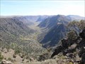
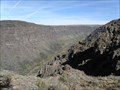
 view gallery view galleryW10.3 km | Kiger Gorge Viewpoint in Scenic Roadside Look-Outs The Kiger Gorge VP along the Steens Mountain Loop Road. posted by: Volcanoguy location: Oregon date approved: 03/05/2011 last visited: 09/29/2007 |
 view gallery view galleryW10.3 km | Bulldozed by Glaciers in Oregon Historical Markers History sign about glaciation of Steens Mountain. The sign located off the Steens Mountain Loop Road at the Kiger Gorge VP. posted by: Volcanoguy location: Oregon date approved: 03/04/2011 last visited: 09/29/2007 |
 view gallery view gallery SW11.6 km SW11.6 km
|  Steen’s Summit Steen’s Summit
in Mountain Summits This entire area has wonderful views in all directions. We love landscapes, especially with long views. This one fits the bill nicely. My wife was very disappointed when she tried to hike to a mountain view point in the Cascades. Too tired from years of cancer treatments she could not make the climb. So, we went for this easy one. posted by: JLJL location: Oregon date approved: 09/07/2005 last visited: 09/03/2012 |
 view gallery view galleryW13.8 km | Basque History on Steens Mountain in Oregon Historical Markers History sign about the Basque on Steens Mountain. The sign located on the Steens Mountain Loop Road near Jackman Park. posted by: Volcanoguy location: Oregon date approved: 03/04/2011 last visited: 08/13/2011 |
 view gallery view galleryW19.6 km | Big Indian Gorge Viewpoint in Scenic Roadside Look-Outs The Big Indian Gorge VP along the Steens Mountain Loop Road. posted by: Volcanoguy location: Oregon date approved: 03/05/2011 last visited: 10/12/2010 |
 view gallery view galleryW19.6 km | Seed Eaters and Cold Dwellers in Oregon Historical Markers History sign about the Northern Paiutes on Steens Mountain. The sign located off the Steens Mountain Loop Road at the Big Indian Grorge VP. posted by: Volcanoguy location: Oregon date approved: 03/07/2011 last visited: 10/12/2010 |
 view gallery view galleryW20 km | Little Blitzen Gorge Viewpoint in Scenic Roadside Look-Outs The Little Blitzen Gorge VP along the Steens Mountain Loop Road. posted by: Volcanoguy location: Oregon date approved: 03/05/2011 last visited: 10/12/2010 |
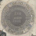 view gallery view gallery S22.7 km S22.7 km
|  NX0078 - USCGS Y65, Oregon NX0078 - USCGS Y65, Oregon
in U.S. Benchmarks U.S. Coast & Geodetic Survey benchmark Y65 posted by: Volcanoguy location: Oregon date approved: 02/27/2011 last visited: 10/01/2009 |
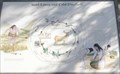
 view gallery view galleryW23.8 km | Juniper Management - Steens Mountain Loop Road, Oregon in Flora and Fauna Information Signs Group of three Flora and Fauna Signs dealing with testing methods of Juniper control. posted by: Volcanoguy location: Oregon date approved: 03/05/2011 last visited: 08/13/2011 |
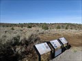 view gallery view galleryW25.7 km | Juniper Invasion - Steens Mountain Loop Road, Oregon in Flora and Fauna Information Signs Group of three Flora and Fauna Signs dealing with causes and effects of the increase in Juniper forests. posted by: Volcanoguy location: Oregon date approved: 03/05/2011 last visited: 08/13/2011 |
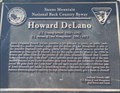 view gallery view gallery NW35.7 km NW35.7 km
|  Howard DeLano - Steens Mountain Loop, Oregon Howard DeLano - Steens Mountain Loop, Oregon
in Citizen Memorials Memorial to Howard DeLano near the beginning of the Steens Mountain Loop Road. posted by: Volcanoguy location: Oregon date approved: 03/04/2011 last visited: 08/13/2011 |
 view gallery view galleryNW40.9 km |  Frenchglen Hotel - Frenchglen, Oregon Frenchglen Hotel - Frenchglen, Oregon
in U.S. National Register of Historic Places The historic Frenchglen Hotel in Frenchglen, Oregon. posted by: Volcanoguy location: Oregon date approved: 03/03/2011 last visited: 09/09/2012 |
 view gallery view galleryNW40.9 km |  Frenchglen, Oregon Frenchglen, Oregon
in American Guide Series Remote, historic southeast Oregon community at the foot of Steens Mountain posted by:  ddtfamily ddtfamily location: Oregon date approved: 10/14/2012 last visited: never |
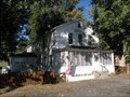
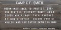 view gallery view gallery SE42.8 km SE42.8 km
| Camp C.F. Smith in Oregon Historical Markers This history sign is located along Whitehorse Road at the junction to the Whitehorse Ranch. posted by: Volcanoguy location: Oregon date approved: 02/28/2011 last visited: 10/01/2009 |
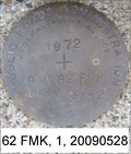 view gallery view gallery NE44.9 km NE44.9 km
| 62 FMK - Malheur County, Oregon in U.S. Benchmarks A Public Roads Administration bench mark disk "B.M. 62 FMK 4252" on the side of OR 78 in Malheur County, OR. posted by: nvtriker location: Oregon date approved: 06/22/2009 last visited: never |
 view gallery view galleryNE46 km | NW0357 - USGS PALOMINO NO 2 - 1972 - Oregon in U.S. Benchmarks U.S. Geological Survey reference mark. posted by: Volcanoguy location: Oregon date approved: 10/30/2016 last visited: 09/23/2016 |
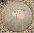 view gallery view galleryNE46 km | NW0357 - PRA PALOMINO - 1972 - Oregon in U.S. Benchmarks Public Roads Administration elevation mark. posted by: Volcanoguy location: Oregon date approved: 10/30/2016 last visited: 09/23/2016 |
 view gallery view galleryNE46 km | NW0357 - USGS PALOMINO NO 1 - 1972 - Oregon in U.S. Benchmarks U.S. Geological Survey reference mark. posted by: Volcanoguy location: Oregon date approved: 10/30/2016 last visited: 09/23/2016 |
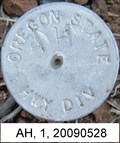 view gallery view galleryE48 km | OREGON STATE HWY DIV AH - US95 - Malheur County, OR in U.S. Benchmarks An Oregon State Highway Division survey mark "AH" on the side of US95 in Malheur County, OR. posted by: nvtriker location: Oregon date approved: 06/23/2009 last visited: never |
 view gallery view gallery N49.1 km N49.1 km
| M 698, PA0570 - Malheur County, Oregon in U.S. Benchmarks Stainless steel rod under a cover. posted by: nvtriker location: Oregon date approved: 06/22/2009 last visited: never |
|