 view gallery view gallery NE2.7 km NE2.7 km
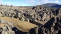
|   Devils Garden - Klamath County, OR Devils Garden - Klamath County, OR
in Geological Devilish Locations A volcanic area located south of the OC&E Woodsline Trail. posted by:  NW_history_buff NW_history_buff location: Oregon date approved: 01/15/2018 last visited: never |
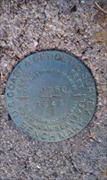 view gallery view gallery E3.9 km E3.9 km
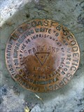
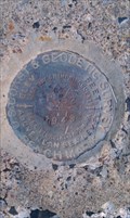
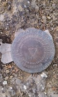
|  NY0379 - USC&GS 'J 350' BM - Klamath County, OR NY0379 - USC&GS 'J 350' BM - Klamath County, OR
in U.S. Benchmarks This NGS benchmark is located off an abandoned dirt road NW from Bliss Rd in Klamath County, OR. posted by: NW_history_buff location: Oregon date approved: 12/16/2012 last visited: never |
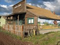
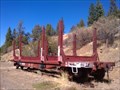 view gallery view galleryNE4.3 km |  Log Hauler at OC&E Woodsline State Trailhead - Klamath County, OR Log Hauler at OC&E Woodsline State Trailhead - Klamath County, OR
in Static Train Cars This log hauler static display is located next to the OC&E Woodsline State Trailhead just off Bliss Road in Klamath County, OR. posted by: NW_history_buff location: Oregon date approved: 09/09/2013 last visited: 10/04/2015 |
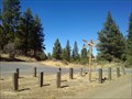 view gallery view galleryNE4.5 km |  OC&E Woods Line State Trailhead - Bliss Road Access - Klamath County, OR OC&E Woods Line State Trailhead - Bliss Road Access - Klamath County, OR
in Rails to Trails This rails-to-trails trailhead access point is located just off Bliss Road in Klamath County, OR. posted by: NW_history_buff location: Oregon date approved: 11/17/2013 last visited: 10/04/2015 |
 view gallery view gallery SE7.1 km SE7.1 km
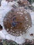
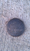
| NY0325 - USC&GS 'F 350' - Klamath County, OR in U.S. Benchmarks This NGS benchmark is imbedded on top of a boulder just west of Egert Rd in Klamath County, OR. posted by: NW_history_buff location: Oregon date approved: 02/20/2013 last visited: never |
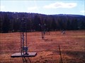
 view gallery view gallery W7.1 km W7.1 km
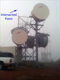
| NY0911 - SWAN LAKE PT BONNEVILLE MICROW - Klamath County, OR in U.S. Benchmarks This microwave tower is located at the summit of Swan Lake Point in Klamath County, OR. posted by: NW_history_buff location: Oregon date approved: 09/24/2013 last visited: never |
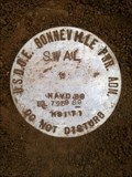 view gallery view galleryW7.1 km | USDOE Bonneville Power Adm 'SWAL' Control Point - Klamath County, OR in U.S. Benchmarks This Bonneville Power Administration control point is located directly under a microwave tower on the summit of Swan Lake Point in Klamath County, OR. posted by: NW_history_buff location: Oregon date approved: 09/24/2013 last visited: never |
 view gallery view galleryW7.1 km | CD8205 - USCGS 'SWAN LAKE NO 1' Reference Mark - Klamath County, OR in U.S. Benchmarks This NGS reference mark is located at the summit of Swan Lake Point in Klamath County, OR. posted by: NW_history_buff location: Oregon date approved: 09/24/2013 last visited: never |
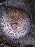
 view gallery view galleryW7.1 km | NY0909 - USCGS 'SWAN LAKE' Triangulation Station - Klamath County, OR in U.S. Benchmarks This NGS triangulation station lies at the summit of Swan Lake Point in Klamath County, OR. posted by: NW_history_buff location: Oregon date approved: 09/24/2013 last visited: never |
 view gallery view galleryW7.1 km | CD8206 - USCGS 'SWAN LAKE NO 2' Reference Mark - Klamath County, OR in U.S. Benchmarks This NGS reference mark is located at the summit of Swan Lake Point in Klamath County, OR. posted by: NW_history_buff location: Oregon date approved: 09/24/2013 last visited: never |
 view gallery view galleryW8.4 km | CD8204 - USCGS 'SWAN LAKE' Azimuth Mark - Klamath County, OR in U.S. Benchmarks This NGS azimuth mark is located SW of a junction of Forest Service Rd 9718 and a track road leading west to the former Swan Lake Lookout Tower in Klamath County, OR. posted by: NW_history_buff location: Oregon date approved: 09/24/2013 last visited: never |
 view gallery view galleryW8.4 km |  CD8204 - USCGS 'SWAN LAKE' Azimuth Mark - Klamath County, OR CD8204 - USCGS 'SWAN LAKE' Azimuth Mark - Klamath County, OR
in Azimuth Benchmarks This NGS azimuth mark is located SW of a junction of Forest Service Rd 9718 and a track road leading west to the former Swan Lake Lookout Tower in Klamath County, OR. posted by: NW_history_buff location: Oregon date approved: 09/23/2013 last visited: never |
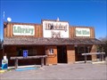 view gallery view galleryNE10.1 km |  Sprague River, OR 97639 Sprague River, OR 97639
in U.S. Post Offices This post office is part of a larger complex containing a trading post and library in Sprague River, OR. posted by: NW_history_buff location: Oregon date approved: 11/21/2013 last visited: 10/04/2015 |
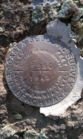
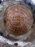
 view gallery view galleryNE10.3 km | NY0567 - USC&GS 'P 352' - Sprague River, OR in U.S. Benchmarks This NGS benchmark is monumented at the top of a concrete staircase of the former Sprague River High School which burned down in the 1960s and only the concrete foundation remains in Sprague River, OR. posted by: NW_history_buff location: Oregon date approved: 02/20/2013 last visited: never |
 view gallery view galleryNE10.8 km | Sprague River Bridge 4305.86 - Sprague River, OR in U.S. Benchmarks This benchmark exists at the newer constructed Sprague River Bridge in Sprague River, OR. posted by: NW_history_buff location: Oregon date approved: 06/05/2012 last visited: never |
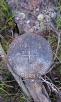
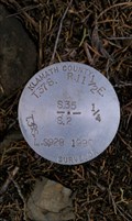 view gallery view gallerySE11.3 km | T37S R11 1/2E SEC 35 T38S SEC 2 1/4 LS 928 - Klamath County, OR in U.S. Benchmarks This section Survey Marker exists at the corner of Egert Rd and Bodnar Lane (a private driveway) in Klamath County, OR. posted by: NW_history_buff location: Oregon date approved: 10/16/2013 last visited: never |
 view gallery view gallerySE11.3 km |  T37S R11 1/2E SEC 35 T38S SEC 2 1/4 LS 928 - Klamath County, OR T37S R11 1/2E SEC 35 T38S SEC 2 1/4 LS 928 - Klamath County, OR
in Public Land Survey Marks This section Survey Marker exists at the corner of Egert Rd and Bodnar Lane (a private driveway) in Klamath County, OR. posted by: NW_history_buff location: Oregon date approved: 07/21/2012 last visited: never |
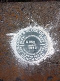
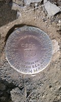 view gallery view gallerySE11.4 km | NY0322 - USC&GS 'C 350' BM - Klamath County, OR in U.S. Benchmarks This NGS benchmark is located off Ebert Rd in Klamath County, OR. posted by: NW_history_buff location: Oregon date approved: 12/16/2012 last visited: never |
 view gallery view gallerySE11.7 km | NY0902 - USC&GS 'JUNIPER ROCK' Series - Klamath County, OR in U.S. Benchmarks This NGS benchmark series is located on a ridge on private property and east of Egert Rd in Klamath County, OR. posted by: NW_history_buff location: Oregon date approved: 02/20/2013 last visited: never |
 view gallery view gallery NW12.2 km NW12.2 km
|  First-Mercantile Store in Northern Klamath County, Oregon First-Mercantile Store in Northern Klamath County, Oregon
in First of its Kind The sign by this building claims it is the "Site of the First Mercantile Store in Northern Klamath County-1909." posted by: Queens Blessing location: Oregon date approved: 06/21/2009 last visited: 10/04/2015 |
 view gallery view gallery N12.4 km N12.4 km
| NY0563 - USC&GS 'K 352' BM - Klamath County, OR in U.S. Benchmarks This NGS benchmark is located along Sprague River Road. posted by: NW_history_buff location: Oregon date approved: 06/17/2016 last visited: never |
 view gallery view galleryW12.7 km | T37S R9E SECS 10 11 14 15 LS 290 Section Corner - Klamath County, OR in Public Land Survey Marks This section corner Survey Marker exists just off of Swan Lake Rd in Klamath County, OR. posted by: NW_history_buff location: Oregon date approved: 07/21/2012 last visited: 10/04/2015 |
 view gallery view galleryW12.7 km | T37S R9E SECS 10 11 14 15 'LS 290' Section Corner - Klamath County, OR in U.S. Benchmarks This section corner Survey Marker exists just off of Swan Lake Rd in Klamath County, OR. posted by: NW_history_buff location: Oregon date approved: 10/17/2013 last visited: 10/04/2015 |
 view gallery view gallery SW12.9 km SW12.9 km
| DK4173 - KLAMATH FALLS 5 CORS ARP - Klamath County, OR in U.S. Benchmarks This is a GPS Continuously Operating Reference Station (CORS) and contains EIGHT PID numbers, all referencing different parts of the station and located just off Swan Lake Rd in Klamath County, OR. posted by: NW_history_buff location: Oregon date approved: 03/04/2014 last visited: 10/04/2015 |
 view gallery view gallerySW12.9 km | DK4174 - KLAMATH FALLS 5 CORS L1 PHASE CENTER - Klamath County, OR in U.S. Benchmarks This is a GPS Continuously Operating Reference Station (CORS) and contains EIGHT PID numbers, all referencing different parts of the station and located just off Swan Lake Rd in Klamath County, OR. posted by: NW_history_buff location: Oregon date approved: 03/03/2014 last visited: 10/04/2015 |
|