 view gallery view gallery NE3.1 km NE3.1 km
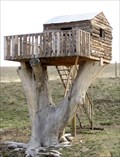
|   Wyoming Treehouse, Wheatland, WY Wyoming Treehouse, Wheatland, WY
in Treehouses This house is visible from northbound Interstate 25, an hour north of Cheyenne. posted by:  ronjean ronjean location: Wyoming date approved: 04/26/2011 last visited: 11/14/2020 |
 view gallery view gallery SE15.1 km SE15.1 km
|  Chugwater Rock Outcroppings - Chugwater, WY Chugwater Rock Outcroppings - Chugwater, WY
in Wyoming Historical Markers A Wyoming's Wildlife marker at the rest area on the east side of I 25, within a minute's drive from Chugwater, provides some background about the wildlife you'll see in the area. posted by:  QuarrellaDeVil QuarrellaDeVil location: Wyoming date approved: 05/26/2020 last visited: never |
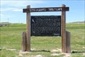
 view gallery view gallerySE15.1 km |  Chugwater Rock Outcroppings - Chugwater, WY Chugwater Rock Outcroppings - Chugwater, WY
in Flora and Fauna Information Signs A Wyoming's Wildlife sign at the rest area on the east side of I 25, within a minute's drive from Chugwater, provides some background about the wildlife you'll see in the area. posted by: QuarrellaDeVil location: Wyoming date approved: 05/29/2020 last visited: never |
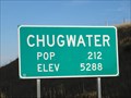 view gallery view gallerySE15.3 km |  Chugwater, WY - Elevation 5288 Chugwater, WY - Elevation 5288
in Elevation Signs Chugwater, WY is at 5288 feet above sea level. posted by: QuarrellaDeVil location: Wyoming date approved: 09/29/2015 last visited: 05/25/2020 |
 view gallery view gallerySE15.3 km |  Chugwater, WY - Population 212 Chugwater, WY - Population 212
in Population Signs Chugwater, WY, population 212 as of this posting. This sign is located on the south side of I-25B/WY 321 at the west end of town. posted by: QuarrellaDeVil location: Wyoming date approved: 10/04/2015 last visited: 05/25/2020 |
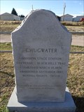 view gallery view gallerySE15.4 km | Chugwater in Wyoming Historical Markers A small, granite marker stands along the main route through Chugwater, WY, providing a small sound byte of information about its time as a stagecoach stop. posted by: QuarrellaDeVil location: Wyoming date approved: 09/27/2015 last visited: 09/29/2021 |
 view gallery view gallery S18.8 km S18.8 km
|  Watchful Cowboy, Chugwater, WY Watchful Cowboy, Chugwater, WY
in Silhouette Public Art Sculptures This horse and rider look over the traffic on the Interstate hiway. posted by: ronjean location: Wyoming date approved: 02/25/2011 last visited: 09/07/2018 |
 view gallery view gallery N19.6 km N19.6 km
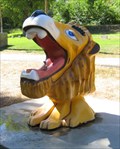
|  Lion Drinking Fountain, Wheatland, WY Lion Drinking Fountain, Wheatland, WY
in Lion Statues The drinking water fountain in Lewis Park. posted by: ronjean location: Wyoming date approved: 09/29/2011 last visited: 06/26/2013 |
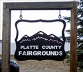 view gallery view galleryN19.8 km |  Platte County Fairgrounds, Wheatland, WY Platte County Fairgrounds, Wheatland, WY
in Agricultural Fairgrounds The Fairgrounds holds many events, from motocross to rodeo to fireworks displays posted by: ronjean location: Wyoming date approved: 07/30/2011 last visited: never |
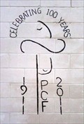 view gallery view galleryN20.1 km |  Platte County Centennial, Wheatland, WY Platte County Centennial, Wheatland, WY
in Community Commemoration The Fairgrounds is the site for the county celebration in 2011 posted by: ronjean location: Wyoming date approved: 07/23/2011 last visited: never |
 view gallery view galleryN20.1 km |  Covenant Lutheran Church - Wheatland, WY Covenant Lutheran Church - Wheatland, WY
in Lutheran Churches This Lutheran church has a prayer garden and a bell choir. posted by: ronjean location: Wyoming date approved: 07/28/2013 last visited: never |
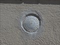
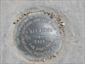 view gallery view galleryN20.1 km |  NGS VCDisk L 119 RESET 1999, Wyoming NGS VCDisk L 119 RESET 1999, Wyoming
in U.S. Benchmarks NGS L 119 RESET, 1999, is a National Geodetic Survey vertical control disk located on the east edge of Wheatland, WY. posted by: seventhings location: Wyoming date approved: 05/17/2009 last visited: never |
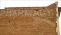 view gallery view galleryN20.1 km |  Pioneer Pharmacy, Wheatland, WY Pioneer Pharmacy, Wheatland, WY
in Ghost Signs The original occupants of this building advertised their pharmacy on the brick wall. posted by: ronjean location: Wyoming date approved: 03/23/2012 last visited: never |
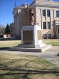 view gallery view galleryN20.3 km |  Statue of Liberty/ WW II Memorial-Wheatland, WY Statue of Liberty/ WW II Memorial-Wheatland, WY
in Statues of Liberty This Statue of Liberty is at the Platte County Court house in Wheatland,Wyoming. posted by: Captain Spaulding location: Wyoming date approved: 03/31/2012 last visited: never |
 view gallery view galleryN20.3 km |  1917 Platte County Courthouse-Wheatland, Wyoming 1917 Platte County Courthouse-Wheatland, Wyoming
in Dated Buildings and Cornerstones This court house was built in 1917 and is on the national historic registry. posted by: Captain Spaulding location: Wyoming date approved: 04/02/2012 last visited: never |
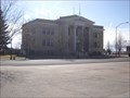 view gallery view galleryN20.3 km |  Platte County Courthouse, Wheatland, Wyoming Platte County Courthouse, Wheatland, Wyoming
in Courthouses The county courthouse is in Wheatland,Wyoming. posted by: Captain Spaulding location: Wyoming date approved: 03/31/2012 last visited: never |
 view gallery view galleryN20.3 km | NQ0185 in U.S. Benchmarks This benchmark is at the Platte County Court House. posted by: Captain Spaulding location: Wyoming date approved: 03/30/2012 last visited: never |
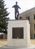 view gallery view galleryN20.3 km |  The Irrigator, Wheatland, WY The Irrigator, Wheatland, WY
in Occupational Monuments Irrigators turned the dry high plains into usable farmland to support the growing population. posted by: ronjean location: Wyoming date approved: 03/21/2012 last visited: 03/30/2012 |
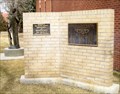 view gallery view galleryN20.4 km |  Platte County Desert Storm Memorial, Wheatland, WY Platte County Desert Storm Memorial, Wheatland, WY
in Persian Gulf War Memorials A plaque dedicated to the service men and service women who served in Desert Storm 1990 - 1991. posted by: ronjean location: Wyoming date approved: 03/21/2012 last visited: 08/08/2017 |
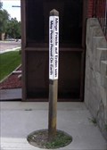 view gallery view galleryN20.4 km |  UCC Peace Pole, Wheatland, WY UCC Peace Pole, Wheatland, WY
in Peace Poles Unusual Pole that has a Native American language included. posted by: ronjean location: Wyoming date approved: 07/22/2011 last visited: 03/30/2012 |
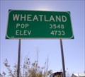 view gallery view galleryN21.1 km | Wheatland, WY in Population Signs Wheatland is about 70 miles north of Cheyenne posted by: ronjean location: Wyoming date approved: 01/01/2011 last visited: never |
 view gallery view gallery W22.5 km W22.5 km
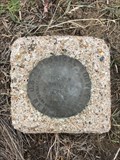
| 10 WWC (MO0374) - Platte County, Wyoming in U.S. Benchmarks This USGS benchmark can be found a short ways to the north of State Highway 34. posted by: Tom.dog location: Wyoming date approved: 12/09/2022 last visited: never |
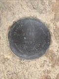 view gallery view galleryW24.5 km | N 166 RESET (MO1339) - Platte County, Wyoming in U.S. Benchmarks An NGS vertical control mark on the west side of State Highway 34. posted by: Tom.dog location: Wyoming date approved: 12/09/2022 last visited: never |
 view gallery view galleryW25.4 km | P 166 RESET (AH7389) - Platte County, Wyoming in U.S. Benchmarks An NGS vertical control disk on the northwest side of State Highway 34. posted by: Tom.dog location: Wyoming date approved: 06/11/2023 last visited: never |
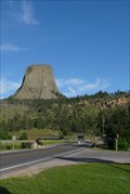 view gallery view gallerySE36.9 km |  Entrance Road--Devils Tower National Monument - Devil's Tower, WY Entrance Road--Devils Tower National Monument - Devil's Tower, WY
in U.S. National Register of Historic Places The CCC built this road in 1935 to improve the existing 8% grade dirt road that was used to access the Monument. posted by: Hikenutty location: Wyoming date approved: 07/16/2007 last visited: 09/19/2023 |
|