 view gallery view gallery SE3.7 km SE3.7 km
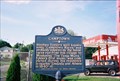
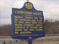
|   Camptown Camptown
in Pennsylvania Historical Markers Camptown Races 5 miles long......... posted by:  Gosffo Gosffo location: Pennsylvania date approved: 10/24/2009 last visited: 07/30/2016 |
 view gallery view gallery SW3.9 km SW3.9 km
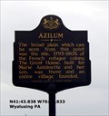
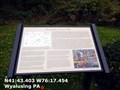
|  Asylum - Wyalusing PA Asylum - Wyalusing PA
in Signs of History A settlement of French Royalists, who fled the French Revolution in 1793, was established in this valley directly opposite this marker. posted by:  Don.Morfe Don.Morfe location: Pennsylvania date approved: 05/31/2020 last visited: 09/26/2021 |
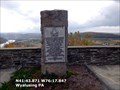
 view gallery view gallerySW3.9 km |  Marie Antoinette Scenic Overlook - Wyalusing, PA Marie Antoinette Scenic Overlook - Wyalusing, PA
in Scenic Roadside Look-Outs This overlook was a 1930s WPA project. It overlooks the French Azilum Historic Site. posted by: ripraff location: Pennsylvania date approved: 08/14/2016 last visited: 04/06/2013 |
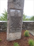 view gallery view gallerySW4 km | Asylum - Wyalusing, PA in Pennsylvania Historical Markers This is an overlook on route 6. The sign describes the settlement of French Royalty who were escaping the Revolution. posted by: ripraff location: Pennsylvania date approved: 08/20/2016 last visited: 04/06/2013 |
 view gallery view gallerySW4 km | Azilum in Pennsylvania Historical Markers The broad plain which can be seen from this point was the site, 1793-1803, of the French refugee colony. posted by: Don.Morfe location: Pennsylvania date approved: 06/05/2020 last visited: 10/19/2021 |
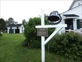
 view gallery view gallerySW4.2 km |  Camptown, PA 18815 Camptown, PA 18815
in U.S. Post Offices This is the post office for Campton, Pennsylvania. posted by: miatabug location: Pennsylvania date approved: 06/29/2007 last visited: 02/21/2015 |
 view gallery view gallerySW4.2 km | Camptown Races in Pennsylvania Historical Markers Do da Do da! posted by: Gosffo location: Pennsylvania date approved: 03/03/2006 last visited: 04/19/2014 |
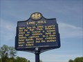 view gallery view gallerySW4.2 km | Lime Hill in Pennsylvania Historical Markers Apr. 14, 1782 posted by: Gosffo location: Pennsylvania date approved: 04/06/2008 last visited: 06/26/2014 |
 view gallery view gallerySW4.2 km | The Battle of Lime Hill - Wyalusing PA in Signs of History The Lime Hill Battlefield, April 14th, 1782. Several hundred yards south west and in front of this marker, a rescue party of eight Patriot men ambushed a war party of thirteen Iroquois Indians posted by: Don.Morfe location: Pennsylvania date approved: 05/31/2020 last visited: 09/26/2021 |
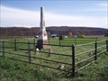
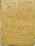 view gallery view gallerySW4.2 km | Battle of Lime Hill, Joseph Elliott Monument in Pennsylvania Historical Markers Monument marking the Battle of Lime Hill on Rt 6 Near Wyalusing. Reverse side of the marker many times goes unseen by visitors. It details the Revolutionary War service and heroic deeds of one of the Battle of Lime Hill soldiers, Joseph Elliott posted by: amaquilter location: Pennsylvania date approved: 09/27/2012 last visited: 06/26/2014 |
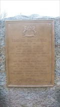 view gallery view gallerySW4.2 km | Lime Hill Battlefield - PLAQUE in Pennsylvania Historical Markers A plaque with a geocache. posted by: unimoggers location: Pennsylvania date approved: 05/10/2009 last visited: 07/30/2016 |
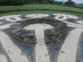 view gallery view gallerySW4.3 km |  Fleur-De-Lis Labyrinth - French Azilum, Towanda, Pennsylvania Fleur-De-Lis Labyrinth - French Azilum, Towanda, Pennsylvania
in Labyrinths This was designed by Robert Possehl using Fleur-De-Lis. posted by: ripraff location: Pennsylvania date approved: 06/07/2018 last visited: never |
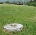 view gallery view gallerySW4.3 km |  Millstone - French Azilum - Towanda, Pa Millstone - French Azilum - Towanda, Pa
in Millstones The millstone is believed to be from French Azilum's Gristmill. It is now in front of John LaPote's house. posted by: ripraff location: Pennsylvania date approved: 06/01/2018 last visited: never |
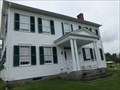 view gallery view gallerySW4.3 km |  John LaPorte House, Asylum, Pennsylvania John LaPorte House, Asylum, Pennsylvania
in Pre-Victorian Historic Homes This house was built in 1836, so it is pre-Victorian. It was built by the son of one of the founders of French Azilum as a summer home. It remained in the family for several years. posted by: ripraff location: Pennsylvania date approved: 06/06/2018 last visited: never |
 view gallery view gallerySW4.3 km |  Ferry Bell - French Azilum, Towanda, PA Ferry Bell - French Azilum, Towanda, PA
in Bells This is a ferry bell for Homet's Ferry. posted by: ripraff location: Pennsylvania date approved: 06/01/2018 last visited: never |
 view gallery view gallerySW4.3 km |  Gazebo - French Azilum, Towanda, PA Gazebo - French Azilum, Towanda, PA
in Gazebos This gazebo was built in 1992 in memory of Martha Hermann, curator of French Azilum. posted by: ripraff location: Pennsylvania date approved: 06/02/2018 last visited: never |
 view gallery view gallerySW4.3 km |  Martha Hermann - French Azilum, Towanda, PA, US Martha Hermann - French Azilum, Towanda, PA, US
in Citizen Memorials This historical site is where the French built a refuge during the French Revolution. They built a house for Marie Antoinette, who never made it here. Napoleon invited them back and others moved to places like New Orleans. A few stayed in the area. posted by: ripraff location: Pennsylvania date approved: 06/01/2018 last visited: never |
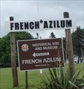 view gallery view gallerySW4.3 km |  French Azilum - Towanda, PA French Azilum - Towanda, PA
in Satellite Imagery Oddities French Azilum on the Susquehanna River was a refuge for those escaping the French Revolution. posted by: ripraff location: Pennsylvania date approved: 06/01/2018 last visited: never |
 view gallery view gallerySW4.7 km |  John Laporte Family Cemetery, Towanda, Bradford County, Pennsylvania John Laporte Family Cemetery, Towanda, Bradford County, Pennsylvania
in Worldwide Cemeteries The John Laporte Family Cemetery is located near the town of Towanda, Bradford County, Pennsylvania. posted by: deano1943 location: Pennsylvania date approved: 10/24/2008 last visited: 05/28/2018 |
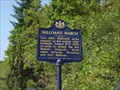 view gallery view gallery W5 km W5 km
| Sullivan's March in Pennsylvania Historical Markers Aug. 8-9, 1779 posted by: Gosffo location: Pennsylvania date approved: 04/06/2008 last visited: 07/09/2014 |
 view gallery view galleryW6.3 km | Sullivan Expedition - Wysox PA in Signs of History Sullivan Expedition Against the Iroquois Indians 1779-from Wyoming to Teaoga August 8-9 1779 opposite the Standing Stone posted by: Don.Morfe location: Pennsylvania date approved: 05/31/2020 last visited: 09/26/2021 |
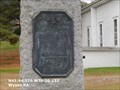
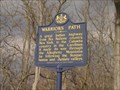 view gallery view gallery S7.1 km S7.1 km
| Warriors Path in Pennsylvania Historical Markers One false step and it's goodbye! Splash! posted by: Gosffo location: Pennsylvania date approved: 03/03/2006 last visited: 07/30/2016 |
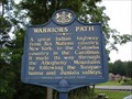 view gallery view galleryS7.1 km |  Warriors Path - near Wyalusing, PA, USA Warriors Path - near Wyalusing, PA, USA
in Ancient Traces and Roads The Warrior's Path ran from South Carolina to New York. posted by: Lightnin Bug location: Pennsylvania date approved: 08/20/2009 last visited: 07/30/2016 |
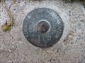 view gallery view galleryS7.1 km |  PENNA. DEPT. OF TRANSPORTATION SURVEY CONTROL MARK - C 179 PENNA. DEPT. OF TRANSPORTATION SURVEY CONTROL MARK - C 179
in U.S. Benchmarks PENNDOT Road Survey Control Mark posted by: 22CaT location: Pennsylvania date approved: 09/01/2010 last visited: 07/09/2014 |
 view gallery view galleryS7.1 km | Wyalusing Rocks - w of Wyalusing, PA, USA in Scenic Roadside Look-Outs Wyalusing Rocks is a locally well known scenic overlook along US Route 6 halfway between Tunkhannock and Towanda, PA. posted by: Lightnin Bug location: Pennsylvania date approved: 08/18/2009 last visited: 07/30/2016 |
|