 view gallery view gallery S1.9 km S1.9 km
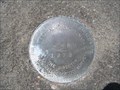
|   J 48 J 48
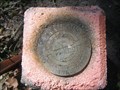
in U.S. Benchmarks U.S. Benchmark Designation J 48 posted by:  Team Smokey Team Smokey location: Massachusetts date approved: 07/04/2007 last visited: never |
 view gallery view galleryS2.1 km |  S Pocasset Church Granite Monument S Pocasset Church Granite Monument
in U.S. Historic Survey Stones and Monuments S Pocasset Church Granite Monument posted by: Team Smokey location: Massachusetts date approved: 07/16/2007 last visited: never |
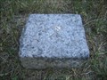 view gallery view galleryS2.1 km | S Pocasset Church Granite Monument in U.S. Benchmarks Granite Monument posted by: Team Smokey location: Massachusetts date approved: 07/02/2007 last visited: never |
 view gallery view gallery SE2.9 km SE2.9 km
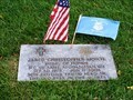
|  Massachusetts National Cemetery - Bourne, Massachusetts Massachusetts National Cemetery - Bourne, Massachusetts
in Veteran Cemeteries The Massachusetts National Cemetery is located on Connery Ave in Bourne, MA. posted by:  Lat34North Lat34North location: Massachusetts date approved: 11/11/2014 last visited: 09/05/2014 |
 view gallery view gallerySE2.9 km |  Massachusetts National Cemetery - Bourne, Massachusetts Massachusetts National Cemetery - Bourne, Massachusetts
in Wikipedia Entries The Massachusetts National Cemetery is located on Connery Ave in Bourne, MA. posted by: Lat34North location: Massachusetts date approved: 11/11/2014 last visited: 09/05/2014 |
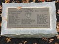 view gallery view gallerySE3.2 km |  Bourne National Cemetery - WW1 Memorial Bourne National Cemetery - WW1 Memorial
in World War I Memorials and Monuments In Memory of Massachusetts WW1 Veterans, located in the Bourne National Cemetery. posted by: WW1HistoryBuff location: Massachusetts date approved: 09/06/2020 last visited: never |
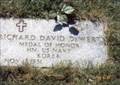 view gallery view gallerySE3.2 km | Richard David Dewert-Bourne, MA in Medal Of Honor Resting Places Korean War Medal of Honor Recipient for action in Korea on April 5, 1951. He was killed in action. He is buried in Massachusetts National Cemetery, Bourne, MA in Section 5, Site 167. posted by: Don.Morfe location: Massachusetts date approved: 01/03/2018 last visited: 12/18/2021 |
 view gallery view gallerySE3.5 km | Jared C. Monti-Bourne, MA in Medal Of Honor Resting Places Afghanistan War Medal of Honor Recipient for action in Nuristan Province, Afghanistan on June 21, 2006. He was killed in action. He is buried in Massachusetts National Cemetery,
Bourne, MA in Section 11, Site 38. posted by: Don.Morfe location: Massachusetts date approved: 03/15/2018 last visited: 12/16/2021 |
 view gallery view gallery W4.3 km W4.3 km
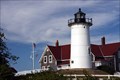
| Nobska Light - Woods Hole, MA in Wikipedia Entries Since 1828, Nobska Light has provided a familiar beacon for “all who go down to the sea in ships”. Located on Church St, Woods Hole, MA. posted by: Lat34North location: Massachusetts date approved: 10/27/2014 last visited: 04/30/2018 |
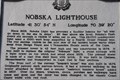 view gallery view galleryW4.3 km |  41 30’ 54” N 70 39’ 20” W - Woods Hole, MA 41 30’ 54” N 70 39’ 20” W - Woods Hole, MA
in Permanent Geographic Coordinates Since 1828, Nobska Light has provided a familiar beacon for “all who go down to the sea in ships”. Located on Church St, Woods Hole, MA. posted by: Lat34North location: Massachusetts date approved: 10/26/2014 last visited: 04/30/2018 |
 view gallery view gallery N5 km N5 km
| CC 306 in U.S. Benchmarks Survey Mark CC 306 posted by: Team Smokey location: Massachusetts date approved: 07/01/2007 last visited: never |
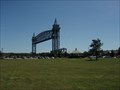
 view gallery view galleryN5 km | Unnamed (by Cape Cod RR bridge) in U.S. Benchmarks ACE Survey Mark posted by: Team Smokey location: Massachusetts date approved: 07/01/2007 last visited: never |
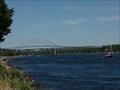
 view gallery view galleryN5 km |  Cape Cod Canal Railroad Bridge - Bourne, MA Cape Cod Canal Railroad Bridge - Bourne, MA
in Railroad Bridges Cape Cod Railroad Bridge posted by: Team Smokey location: Massachusetts date approved: 07/02/2007 last visited: 06/10/2018 |
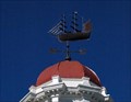 view gallery view galleryN5.1 km |  Whaling Bark "Lagoda" Whaling Bark "Lagoda"
in Unique Weathervanes Model of the whaling bark "Lagoda" atop the Bourne library. posted by: CCD & Lady Di location: Massachusetts date approved: 09/04/2006 last visited: never |
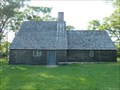 view gallery view galleryN5.1 km |  Apticxet Traning Post - Bourne, MA Apticxet Traning Post - Bourne, MA
in History Museums This is a replica erected in 1930 of the Apticxet Trading Post and the foundations of what is believed by some to be the original foundation of the building dating from 1627. posted by: silverquill location: Massachusetts date approved: 12/21/2014 last visited: never |
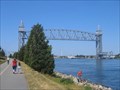
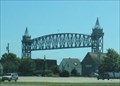
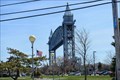 view gallery view galleryN5.1 km |  Cape Cod Canal Railroad Bridge - Buzzards Bay MA Cape Cod Canal Railroad Bridge - Buzzards Bay MA
in Moving Bridges The Cape Cod Railroad Bridge is a veritical lift bridge. posted by: nomadwillie location: Massachusetts date approved: 04/25/2015 last visited: 06/10/2018 |
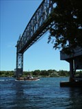
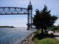
 view gallery view galleryN5.3 km |  Cape Cod Canal - Massachusetts Cape Cod Canal - Massachusetts
in WPA Projects When the original Cape Cod Canal, of 1914, proved too narrow and shallow, in 1928 Congress, charged the U.S. Corps of Engineers with the task of widening the canal, employing 11,000 men through the WPA. Three new bridges were built as PWA projects. posted by: silverquill location: Massachusetts date approved: 08/27/2009 last visited: 06/10/2018 |
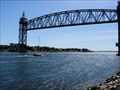 view gallery view galleryN5.3 km | Cape Cod Canal Railroad Bridge - Buzzards Bay, MA in WPA Projects Opened in 1935, this 544-foot span vertical lift bridge is a landmark and important transportation link, spanning the Cap Cod Canal, connecting the cape with the mainland. It was a WPA-PWA project employing over 700 men. posted by: silverquill location: Massachusetts date approved: 08/27/2009 last visited: 06/10/2018 |
 view gallery view galleryN5.3 km |  WIDEST - Sea-Level Canal in the World - Cape Cod Canal WIDEST - Sea-Level Canal in the World - Cape Cod Canal
in Superlatives When the original Cape Cod Canal, of 1914, proved too narrow and shallow, in 1928 Congress, charged the U.S. Corps of Engineers with the task of widening the canal to a width of 480 feet, making it the widest sea-level canal in the world. posted by: silverquill location: Massachusetts date approved: 08/28/2009 last visited: 06/10/2018 |
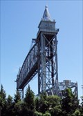
 view gallery view galleryN5.3 km | LONGEST - Verticle Lift Bridge Built by a Government Agency - Cape Cod Canal Railroad Bridge - Buzzard's Bay, MA in Superlatives Opened in 1935, this 544-foot span vertical lift bridge was built by the U.S. Army Corps of Engineers, the longest ever built by a U.S. Government Agency. It was financed under the New Deal, WPA and PWA projects. posted by: silverquill location: Massachusetts date approved: 08/29/2009 last visited: 06/10/2018 |
 view gallery view galleryN5.3 km |  Buzzards Bay Recreation Area - Buzzards Bay, MA Buzzards Bay Recreation Area - Buzzards Bay, MA
in Municipal Parks and Plazas This is a 20-acre park at the south end of the scenic Cape Cod Canal at the base of the vertical lift railroad bridge. posted by: silverquill location: Massachusetts date approved: 08/29/2009 last visited: 04/30/2018 |
 view gallery view galleryN5.3 km |  Cape Cod Canal Railroad Bridge - Buzzard's Bay, MA Cape Cod Canal Railroad Bridge - Buzzard's Bay, MA
in Truss Bridges Opened in 1935, this 544-foot span vertical lift bridge is a landmark and important transportation link, spanning the Cap Cod Canal, connecting the cape with the mainland. The span remains in the raised position until a train needs to cross. posted by: silverquill location: Massachusetts date approved: 08/25/2009 last visited: 06/10/2018 |
 view gallery view galleryN5.3 km |  Cape Cod Canal Trail - Buzzards Bay, MA Cape Cod Canal Trail - Buzzards Bay, MA
in Hiking and walking trailheads The Cape Cod Trail is a multiuse paved trail along extending for about seven miles along the Cape Cod Canal from the landmark vertical lift railroad bridge to the Bourne Bridge. There is an extension that continues another seven miles. posted by: silverquill location: Massachusetts date approved: 08/29/2009 last visited: 06/10/2018 |
 view gallery view galleryN5.3 km |  Cape Cod Canal Railroad Bridge - Buzzard's Bay, MA Cape Cod Canal Railroad Bridge - Buzzard's Bay, MA
in Active Rail Locations Opened in 1935, this 544-foot span vertical lift bridge is a landmark spanning the Cap Cod Canal, connecting the cape with the mainland. It is fascinating to watch it lowered so trains can pass over the canal, though now mainly trash trains use it. posted by: silverquill location: Massachusetts date approved: 08/29/2009 last visited: 06/10/2018 |
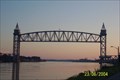 view gallery view galleryN5.3 km | Cape Cod Canal train bridge in Vertical Lift Bridges This bridge connects the mainland to the cape. posted by: KINGANDI location: Massachusetts date approved: 03/19/2006 last visited: 06/10/2018 |
|