 view gallery view gallery NE5.3 km NE5.3 km
|   STATION NO. 22 - Albany County, Wyoming STATION NO. 22 - Albany County, Wyoming
in U.S. Benchmarks A U.S. Coast & Geodetic Survey and State Survey marker on the north side of County Road 51. posted by:  Tom.dog Tom.dog location: Wyoming date approved: 10/21/2022 last visited: never |
 view gallery view gallery SE8.4 km SE8.4 km
| STATION NO. 9 - Albany County, Wyoming in U.S. Benchmarks A U.S. Coast & Geodetic Survey and State Survey marker located at the top of a small hill approximately 0.2 miles west of County Road 55. posted by: Tom.dog location: Wyoming date approved: 10/21/2022 last visited: never |
 view gallery view gallery N8.7 km N8.7 km
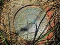
| STATION NO. 55 - Albany County, Wyoming in U.S. Benchmarks A destroyed U.S. Coast & Geodetic Survey and State Survey marker to the west of County Road 51. posted by: Tom.dog location: Wyoming date approved: 10/21/2022 last visited: never |
 view gallery view galleryN9.5 km | STATION NO. 64 - Albany County, Wyoming in U.S. Benchmarks A U.S. Coast & Geodetic Survey and State Survey marker on the west side of County Road 51. posted by: Tom.dog location: Wyoming date approved: 10/21/2022 last visited: never |
 view gallery view galleryNE10.8 km | 48 (MO0610) - Albany County, Wyoming in U.S. Benchmarks A U.S. Coast & Geodetic Survey and State Survey disk on the northeast side of U.S. Highway 287/30. posted by: Tom.dog location: Wyoming date approved: 04/17/2023 last visited: never |
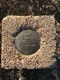
 view gallery view gallerySE14.8 km | LARAMIE RM 3 (MO0593) - Albany County, Wyoming in U.S. Benchmarks Reference mark 3 for triangulation station LARAMIE (MO0594). posted by: Tom.dog location: Wyoming date approved: 04/17/2023 last visited: never |
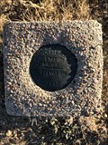
 view gallery view gallerySE14.8 km | LARAMIE RM 1 (MO0595) - Albany County, Wyoming in U.S. Benchmarks Reference mark 1 for triangulation station LARAMIE (MO0594). posted by: Tom.dog location: Wyoming date approved: 04/17/2023 last visited: never |
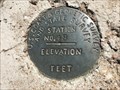
 view gallery view gallerySE14.8 km | LARAMIE (MO0594) - Albany County, Wyoming in U.S. Benchmarks This triangulation station is located on a high point on the north side of the city of Laramie. posted by: Tom.dog location: Wyoming date approved: 04/17/2023 last visited: never |
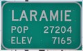 view gallery view gallerySE15 km |  Laramie, Wyoming ~ Population 27,204 Laramie, Wyoming ~ Population 27,204
in Population Signs This combination Elevation/Population sign is at the northern city limits of Laramie, Wyoming on US Highway 30/287 at PFE Road. posted by: brwhiz location: Wyoming date approved: 09/25/2012 last visited: 07/17/2014 |
 view gallery view gallerySE15 km |  Laramie, Wyoming ~ Elevation 7165 Laramie, Wyoming ~ Elevation 7165
in Elevation Signs This combination Elevation/Population sign is at the northern city limits of Laramie, Wyoming on US Highway 30/287 at PFE Road. posted by: brwhiz location: Wyoming date approved: 09/25/2012 last visited: 07/17/2014 |
 view gallery view gallerySE15 km |  McDonalds Snowy Range Road Free WiFi ~ Laramie, Wyoming McDonalds Snowy Range Road Free WiFi ~ Laramie, Wyoming
in Wi-Fi Hotspots Free WiFi Served Daily at the McDonalds at 1666 Snowy Range Road in Laramie, Wyoming. posted by: brwhiz location: Wyoming date approved: 11/21/2012 last visited: never |
 view gallery view gallerySE15 km |  McDonald's - Snowy Range Road, Laramie, WY McDonald's - Snowy Range Road, Laramie, WY
in McDonald's Restaurants McDonalds restaurant on Snowy Range Road, Laramie, WY. posted by:  skrabut skrabut location: Wyoming date approved: 08/06/2006 last visited: 04/27/2010 |
 view gallery view gallerySE15.1 km |  Wyoming Territorial Prison Museum Penny Smasher Wyoming Territorial Prison Museum Penny Smasher
in Penny Smashers This single-design Penny Smasher is in the Wyoming Territorial Prison Museum at 975 Snowy Range Road in Laramie, Wyoming. posted by: brwhiz location: Wyoming date approved: 10/22/2011 last visited: never |
 view gallery view gallerySE15.3 km |  Wyoming Territorial Park Wyoming Territorial Park
in History Museums Built in 1872, the prison held some of the most notorious outlaws in the region, including Butch Cassidy. posted by: skrabut location: Wyoming date approved: 08/06/2006 last visited: 03/17/2015 |
 view gallery view gallerySE15.3 km |  Thunderbird Lodge - Laramie, Wyoming Thunderbird Lodge - Laramie, Wyoming
in Artistic Neon Lights This fun sign can be found along what was originally the Lincoln Highway. posted by: Hikenutty location: Wyoming date approved: 07/13/2007 last visited: 07/04/2010 |
 view gallery view gallerySE15.3 km | Thunderbird Lodge - Laramie, Wyoming in Neon Signs This fun sign can be found along what was originally the Lincoln Highway.
posted by: Hikenutty location: Wyoming date approved: 10/19/2007 last visited: 07/04/2010 |
 view gallery view galleryN15.6 km | S 88 (MO0688) - Albany County, Wyoming in U.S. Benchmarks A benchmark disk on the east side of US 30/287. posted by: Tom.dog location: Wyoming date approved: 11/21/2022 last visited: never |
 view gallery view gallerySE15.9 km |  Sweet Melissa - Laramie, WY Sweet Melissa - Laramie, WY
in Vegetarian Eateries Comfort food for the homesick vegetarian. posted by: siff location: Wyoming date approved: 10/14/2021 last visited: 10/16/2021 |
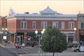 view gallery view gallerySE15.9 km |  Johnson Hotel - Laramie Downtown Historic District - Laramie WY Johnson Hotel - Laramie Downtown Historic District - Laramie WY
in NRHP Historic Districts - Contributing Buildings The Johnson Hotel, a contributing building to the National Register Laramie Downtown Historic District in downtown Laramie WY posted by: Benchmark Blasterz location: Wyoming date approved: 02/24/2018 last visited: 06/27/2009 |
 view gallery view gallerySE15.9 km |  Johnson Hotel -- Laramie WY Johnson Hotel -- Laramie WY
in Lincoln Highway The Johnson Hotel, built on Grand Street as a railroad hotel in 1900 before the era of the automobile, found itself after the era of the auto began right on the Lincoln Highway posted by: Benchmark Blasterz location: Wyoming date approved: 02/22/2018 last visited: 06/27/2009 |
 view gallery view gallerySE15.9 km |  Laramie Downtown Historic District -- Laramie WY Laramie Downtown Historic District -- Laramie WY
in U.S. National Register of Historic Places The Laramie Downtown Historic District consists of 56 contributing buildings spread over 10.5 blocks in downtown Laramie WY. posted by: Benchmark Blasterz location: Wyoming date approved: 02/22/2018 last visited: 06/27/2009 |
 view gallery view gallerySE16.1 km |  UP Yard Bridge -- Laramie WY UP Yard Bridge -- Laramie WY
in Truss Bridges This elevated Warren through truss bridge was built over the UP yard to give railyard workers a safe and convenient crossing point to get from one side of the yard to the other posted by: Benchmark Blasterz location: Wyoming date approved: 02/21/2018 last visited: 09/03/2018 |
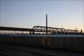 view gallery view gallerySE16.1 km | Garfield Street Bridge - Laramie Downtown Historic District - Laramie WY in NRHP Historic Districts - Contributing Buildings An elevated Warren through truss bridge built over the UP yard in 1930 is a contributing structure to the National Register Laramie Downtown Historic District in downtown Laramie WY posted by: Benchmark Blasterz location: Wyoming date approved: 02/24/2018 last visited: 09/03/2018 |
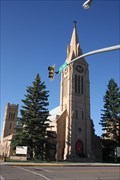 view gallery view gallerySE16.1 km |  St. Matthew's Episcopal Cathedral - Laramie, WY St. Matthew's Episcopal Cathedral - Laramie, WY
in Anglican and Episcopal Churches The elegant Gothic-style St. Matthew's Episcopal Cathedral in downtown Laramie WY posted by: Benchmark Blasterz location: Wyoming date approved: 02/23/2018 last visited: 09/03/2018 |
 view gallery view gallerySE16.1 km | St. Matthew's Episcopal Cathedral - Laramie Downtown Historic District - Laramie WY in NRHP Historic Districts - Contributing Buildings St. Matthew's Episcopal Cathedral is a contributing building to the Laramie Downtown Historic District in Laramie WY posted by: Benchmark Blasterz location: Wyoming date approved: 02/24/2018 last visited: 09/03/2018 |
|