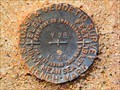
 view gallery view gallery SW0.3 km SW0.3 km
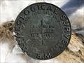
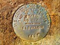
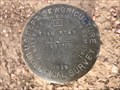
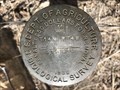
|   7313 LARAMIE NO 7 - Albany County, Wyoming 7313 LARAMIE NO 7 - Albany County, Wyoming
in U.S. Benchmarks A USGS pipe cap on the southeast side of State Highway 230. posted by:  Tom.dog Tom.dog location: Wyoming date approved: 01/08/2023 last visited: never |
 view gallery view gallery NE4.7 km NE4.7 km
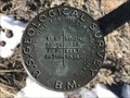
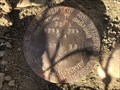
| 7276 LARAMIE NO 6 - Albany County, Wyoming in U.S. Benchmarks A USGS pipe cap on the northwest side of State Highway 230. posted by: Tom.dog location: Wyoming date approved: 01/08/2023 last visited: never |
 view gallery view gallery W5.3 km W5.3 km
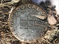
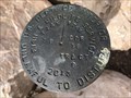
| 7366 LARAMIE NO 8 - Albany County, Wyoming in U.S. Benchmarks A USGS pipe cap on the northwest side of State Highway 230. posted by: Tom.dog location: Wyoming date approved: 01/08/2023 last visited: never |
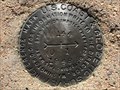
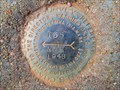
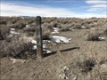
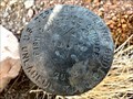
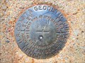
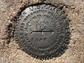 view gallery view galleryW5.8 km | 144 Azimuth Mark - Albany County, Wyoming in U.S. Benchmarks The azimuth mark for destroyed secondary triangulation station 144. posted by: Tom.dog location: Wyoming date approved: 01/08/2023 last visited: never |
 view gallery view galleryW5.8 km |  144 Azimuth Mark - Albany County, Wyoming 144 Azimuth Mark - Albany County, Wyoming
in Azimuth Benchmarks The azimuth mark for destroyed secondary triangulation station 144 (MO1280). posted by: Tom.dog location: Wyoming date approved: 07/02/2023 last visited: never |
 view gallery view galleryW6.1 km | 144 NO 1 - Albany County, Wyoming in U.S. Benchmarks Reference mark 1 for destroyed secondary triangulation station 144. posted by: Tom.dog location: Wyoming date approved: 01/08/2023 last visited: never |
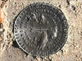 view gallery view galleryW6.1 km | 144 NO 2 - Albany County, Wyoming in U.S. Benchmarks Reference mark 2 for destroyed secondary triangulation station 144. posted by: Tom.dog location: Wyoming date approved: 01/08/2023 last visited: never |
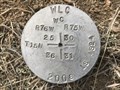 view gallery view gallery N6.8 km N6.8 km
|  T15N R76W S25 S36 R75W S30 S31 WC - Albany County, Wyoming T15N R76W S25 S36 R75W S30 S31 WC - Albany County, Wyoming
in Public Land Survey Marks A WLC witness corner marker in the Twin Buttes Public Access Area. posted by: Tom.dog location: Wyoming date approved: 02/18/2023 last visited: never |
 view gallery view galleryN6.9 km | T15N R75W S30 S31 E 1/16 - Albany County, Wyoming in Public Land Survey Marks This Wyoming Game & Fish Commission sixteenth corner marker is located on the south side of the Twin Buttes Public Access Area. posted by: Tom.dog location: Wyoming date approved: 12/23/2022 last visited: never |
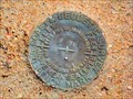
 view gallery view gallery E8 km E8 km
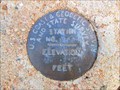
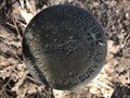
| STATION NO. 134 - Albany County, Wyoming in U.S. Benchmarks A severely damaged U.S. Coast & Geodetic Survey and State Survey disk that serves as the azimuth mark for benchmark 135 (MO1273). posted by: Tom.dog location: Wyoming date approved: 11/21/2022 last visited: never |
 view gallery view galleryE8.5 km | 135 NO 2 - Albany County, Wyoming in U.S. Benchmarks Reference mark 2 for U.S. Coast & Geodetic Survey and State Survey station number 135 (MO1273). posted by: Tom.dog location: Wyoming date approved: 11/21/2022 last visited: never |
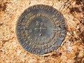
 view gallery view galleryE8.5 km | 135 (MO1273) - Albany County, Wyoming in U.S. Benchmarks A U.S. Coast & Geodetic Survey and State Survey disk on the west side of Brubaker Lane (County Road 37). posted by: Tom.dog location: Wyoming date approved: 11/21/2022 last visited: never |
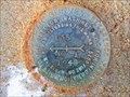 view gallery view galleryE8.5 km | 135 NO 1 - Albany County, Wyoming in U.S. Benchmarks Reference mark 1 for U.S. Coast & Geodetic Survey and State Survey station number 135 (MO1273). posted by: Tom.dog location: Wyoming date approved: 11/21/2022 last visited: never |
 view gallery view galleryE12.1 km | T14N R74W S8 S17 - Albany County, Wyoming in Public Land Survey Marks This 1932 USDA Biological Survey disk denotes where the boundary of the Hutton Lake National Wildlife Refuge crosses the line between sections 8 and 17. posted by: Tom.dog location: Wyoming date approved: 02/18/2023 last visited: never |
 view gallery view galleryE12.4 km | 7334 LARAMIE - Albany County, WY in U.S. Benchmarks A USGS benchmark on the northwest side of Sand Creek Road. posted by: Tom.dog location: Wyoming date approved: 02/18/2023 last visited: never |
 view gallery view galleryN12.4 km | T15N R76W S12 R75W S7 1/4 - Albany County, Wyoming in Public Land Survey Marks A USDI-Bureau of Land Management quarter corner marker on the west side of Big Hollow Road. posted by: Tom.dog location: Wyoming date approved: 12/23/2022 last visited: never |
 view gallery view galleryE12.6 km | T14N R74W S8 COR 18 TRACT 9 - Albany County, Wyoming in Public Land Survey Marks A USDI - Fish & Wildlife Service marker on the boundary of the Hutton Lake National Wildlife Refuge. posted by: Tom.dog location: Wyoming date approved: 02/18/2023 last visited: never |
 view gallery view galleryE12.7 km | T14N R74W S17 S16 1/4 - Albany County, Wyoming in Public Land Survey Marks A partially buried quarter corner stone marker in the Hutton Lake National Wildlife Refuge. posted by: Tom.dog location: Wyoming date approved: 02/18/2023 last visited: never |
 view gallery view galleryE12.9 km | T14N R74W S8 S9 S17 S16 - Albany County, Wyoming in Public Land Survey Marks This 1932 USDA Biological Survey section corner disk is located in the Hutton Lake National Wildlife Refuge. posted by: Tom.dog location: Wyoming date approved: 02/18/2023 last visited: never |
 view gallery view galleryE13 km | T14N R74W S8 S9 1/4 - Albany County, Wyoming in Public Land Survey Marks A USDI - Fish & Wildlife Service quarter corner marker on the boundary of the Hutton Lake National Wildlife Refuge. posted by: Tom.dog location: Wyoming date approved: 02/18/2023 last visited: never |
 view gallery view galleryE13.4 km | T14N R74W S9 W 1/16 - Albany County, Wyoming in Public Land Survey Marks A USDA Biological Survey sixteenth corner disk from 1940 located along the boundary of the Hutton Lake National Wildlife Refuge. posted by: Tom.dog location: Wyoming date approved: 02/18/2023 last visited: never |
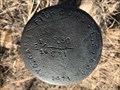
 view gallery view gallery SE15 km SE15 km
| Z 78 (MO0664) - Albany County, Wyoming in U.S. Benchmarks A benchmark on the north side of Bull Mountain Road. posted by: Tom.dog location: Wyoming date approved: 11/21/2022 last visited: never |
 view gallery view gallerySE15 km | Y 78 (MO0663) - Albany County, Wyoming in U.S. Benchmarks This U.S. Coast & Geodetic Survey benchmark can be found on the north side of Sportsman Lake Road. posted by: Tom.dog location: Wyoming date approved: 11/21/2022 last visited: never |
 view gallery view gallerySE15.8 km | X 78 (MO0662) - Albany County, Wyoming in U.S. Benchmarks A benchmark on the south side of Sportsman Lake Road. posted by: Tom.dog location: Wyoming date approved: 11/21/2022 last visited: never |
 view gallery view gallerySE15.9 km | W 78 (MO0661) - Albany County, Wyoming in U.S. Benchmarks A benchmark on the west side of Sportsman Lake Road approximately 0.15 miles southwest of the Antelope Creek crossing. posted by: Tom.dog location: Wyoming date approved: 11/21/2022 last visited: never |
|