 view gallery view gallery NE1 km NE1 km
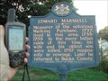
|   EDWARD MARSHALL EDWARD MARSHALL
in Pennsylvania Historical Markers I'm still looking for the Walking Purchase marker, but here's a close second. posted by:  unimoggers unimoggers location: Pennsylvania date approved: 09/20/2005 last visited: 08/12/2013 |
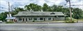 view gallery view galleryNE1 km |  DL&W Railroad Station - Portland PA DL&W Railroad Station - Portland PA
in Train Stations/Depots This is an original Delaware, Lackawanna and Western Railroad Station located in Portland PA and on an active rail. posted by: nomadwillie location: Pennsylvania date approved: 10/14/2019 last visited: 06/20/2010 |
 view gallery view gallery N1.8 km N1.8 km
| Slateford in Pennsylvania Historical Markers One of the first attempts to quarry slate in this country was made here at Slateford by a company chartered in 1808 posted by:  Don.Morfe Don.Morfe location: Pennsylvania date approved: 06/05/2020 last visited: 10/19/2021 |
 view gallery view galleryN2.3 km |  Delaware, Lackawanna, and Western Railroad NJ Cutoff Viaduct 1911 - Near Mount Bethel, PA and Columbia, NJ Delaware, Lackawanna, and Western Railroad NJ Cutoff Viaduct 1911 - Near Mount Bethel, PA and Columbia, NJ
in Railroad Bridges From their website:
Considered by many to be the most scenic rail line in New Jersey, the Lackawanna Cut-Off was the last mainline to be built in the state (it was opened in 1911). posted by: unimoggers location: New Jersey date approved: 04/09/2008 last visited: 08/12/2013 |
 view gallery view galleryN2.3 km |  Philip Lamonaco Memorial Philip Lamonaco Memorial
in Police Memorials This is a memorial to NJ State Trooper Philip Lamonaco. The memorial is right on Route 80 West. There is access to the monument off a road that runs paralel to Route 80 that you can pick up just past the monument. posted by: 79scouts location: New Jersey date approved: 07/05/2010 last visited: 05/22/2012 |
 view gallery view gallery SE3.2 km SE3.2 km
|  Delaware Bridge (Lackawanna Railroad) Delaware Bridge (Lackawanna Railroad)
in Orphaned Bridges Lackawanna Railroad Bridge over Delaware River in Delaware, NJ posted by: dbenz13 location: New Jersey date approved: 03/21/2009 last visited: 02/09/2015 |
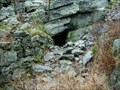 view gallery view galleryN5.5 km | ") Pocono Cold Air Cave Pocono Cold Air Cave
in Cave Entrances (Natural) Pocono Cold Air Cave posted by: Team_Zigbot location: Pennsylvania date approved: 10/23/2006 last visited: 05/21/2011 |
 view gallery view galleryN5.8 km |  Mt. Tammany via Red Dot Trail - Delaware Water Gap, NJ Mt. Tammany via Red Dot Trail - Delaware Water Gap, NJ
in Scenic Hikes The Red Dot Trail climbs 1300 ft over 1.5 miles from the Dunnfield parking lot to the top of Mt. Tammany in the Delaware Water Gap. posted by: Lightnin Bug location: New Jersey date approved: 11/23/2010 last visited: 01/23/2022 |
 view gallery view galleryN5.8 km |  Mt. Tammany, Delaware Water Gap, NJ Mt. Tammany, Delaware Water Gap, NJ
in Mountain Summits Mt. Tammany, Delaware Water Gap, NJ posted by: RMR45 location: New Jersey date approved: 08/25/2008 last visited: 05/08/2008 |
 view gallery view galleryN6 km |  Delaware Water Gap - between New Jersey and Pennsylvania Delaware Water Gap - between New Jersey and Pennsylvania
in Named Mountain Gaps The Delaware Water Gap is formed by the Delaware River as it flows between New Jersey an Pennsylvania. posted by: Lightnin Bug location: New Jersey date approved: 11/20/2010 last visited: 12/28/2022 |
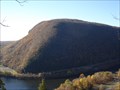 view gallery view galleryN6 km |  Delaware Water Gap - Between PA and NJ Delaware Water Gap - Between PA and NJ
in American Guide Series The Appalachians are Bisected by the famous Delaware Water Gap, 900 feet wide at the base and 4,500 feet wide at the top, with sides rising to a height of 1,200 feet or more. posted by: Lightnin Bug location: New Jersey date approved: 11/23/2010 last visited: 12/28/2022 |
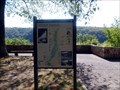
 view gallery view galleryN6.3 km |  Kittatinny Point Visitor Center - Columbia, NJ Kittatinny Point Visitor Center - Columbia, NJ
in Direction and Distance Arrows Some directional arrows at the Delaware Water Gap. posted by: chrissyml location: New Jersey date approved: 09/06/2021 last visited: 12/28/2022 |
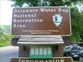
 view gallery view galleryN6.3 km | ") Delaware Water Gap National Recreation Area-Kittatinny Point - Columbia NJ Delaware Water Gap National Recreation Area-Kittatinny Point - Columbia NJ
in National Parks (U.S.) Hike to the top of Mount Tammy for a bird’s eye view of the spectacular Delaware Water Gap. The Park has 40 miles of the Middle Delaware National Scenic and Recreational River and 67,000 acres of forested mountains and riverine valleys, posted by: Don.Morfe location: New Jersey date approved: 12/27/2022 last visited: 12/28/2022 |
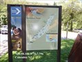
 view gallery view galleryN6.3 km |  You Are Here Map-Kittatinny Point Delaware Water Gap National Recreation Area - Columbia NJ You Are Here Map-Kittatinny Point Delaware Water Gap National Recreation Area - Columbia NJ
in 'You Are Here' Maps You Are Here Map is at the Visitor Center of the Kittatinny Point Delaware Water Gap National Recreation Area - Columbia NJ posted by: Don.Morfe location: New Jersey date approved: 12/28/2022 last visited: 12/28/2022 |
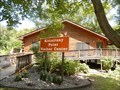 view gallery view galleryN6.3 km |  Ranger Station at Delaware Water Gap National Recreation Area-Kittatinny Point - Columbia NJ Ranger Station at Delaware Water Gap National Recreation Area-Kittatinny Point - Columbia NJ
in Ranger Stations The Ranger Station is in the Visitor Center of Delaware Water Gap National Recreation Area, Kittatinny Point - Columbia NJ. Here one may obtain a NPS Cancellation Stamp. posted by: Don.Morfe location: New Jersey date approved: 12/30/2022 last visited: 12/28/2022 |
 view gallery view galleryN6.3 km |  Delaware Water Gap Kittatinny NJ Delaware Water Gap Kittatinny NJ
in NPS Passport Cancellation Stations For 40 miles the Middle Delaware River passes between low forested mountains with barely a house in sight. Then the river cuts through the mountain ridge to form the famed "Water Gap." posted by: nomadwillie location: New Jersey date approved: 11/10/2008 last visited: 12/28/2022 |
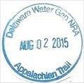 view gallery view galleryN6.3 km | Delaware Water Gap NRA-Appalachian Trail - Kittatinny, NJ in NPS Passport Cancellation Stations This NPS Passport Cancellation Stamp was obtained at the Visitor Center, Delaware Water Gap National Recreation Area, Kittatinny, NJ posted by: Don.Morfe location: New Jersey date approved: 03/04/2020 last visited: 01/22/2022 |
 view gallery view galleryN6.3 km | Delaware Water Gap National Recreation Area in Named Mountain Gaps A mountain pass on the border of New Jersey and Pennsylvania. posted by: unimoggers location: Pennsylvania date approved: 08/15/2007 last visited: 12/28/2022 |
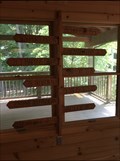
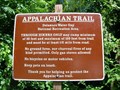 view gallery view galleryN6.3 km |  AT at Interstate 80 in Delaware Water Gap, Pennsylvania AT at Interstate 80 in Delaware Water Gap, Pennsylvania
in Appalachian Trail The AT crosses under Interstate 80 here in DWG. The park has a nice picnicing area along the Delaware River and a brand new ranger station that the government finally build away from the river. It took then a long time to realize the Delaware floods! posted by: unimoggers location: New Jersey date approved: 08/21/2007 last visited: 11/13/2010 |
 view gallery view galleryN6.8 km |  Kittatinny Point Visitor Center Kittatinny Point Visitor Center
in U.S. Benchmarks A bencamark on the sw corder of the Kittatinny Point Visitor Center of the Delaware Water Gap National Recreation Area. posted by: evrik location: New Jersey date approved: 12/16/2005 last visited: 12/28/2022 |
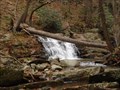 view gallery view galleryN6.9 km |  Waterfall on Dunnfield Creek - Delaware Water Gap, NJ, USA Waterfall on Dunnfield Creek - Delaware Water Gap, NJ, USA
in Waterfalls A beautiful small waterfall is in the Dunnfield Creek Natural Area. posted by: Lightnin Bug location: New Jersey date approved: 12/17/2010 last visited: 12/30/2011 |
 view gallery view galleryN7.4 km |  Delaware Water Gap National Recreation Area - Stroudsburg PA. Delaware Water Gap National Recreation Area - Stroudsburg PA.
in National Parks of the World The Delaware Water Gap National Recreation Area is a unit of the National Park system stretches along both sides of the middle Delaware River for 40 miles from Milford in the north to the scenic Water Gap in the south. posted by: Don.Morfe location: Pennsylvania date approved: 12/27/2022 last visited: 12/28/2022 |
 view gallery view galleryN7.4 km |  Delaware Water Gap National Recreation Area - Stroudsburg PA. Delaware Water Gap National Recreation Area - Stroudsburg PA.
in Wikipedia Entries The Delaware Water Gap National Recreation Area is a unit of the National Park system stretches along both sides of the middle Delaware River for 40 miles from Milford in the north to the scenic Water Gap in the south. posted by: Don.Morfe location: Pennsylvania date approved: 12/27/2022 last visited: 12/28/2022 |
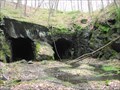 view gallery view gallerySE7.7 km |  Manunka Chunk Tunnels Manunka Chunk Tunnels
in Abandoned Train Tunnels An abandoned train tunnel in Northern NJ! posted by: ODragon location: New Jersey date approved: 07/17/2008 last visited: 05/28/2011 |
 view gallery view gallerySE7.9 km | Manunka Chunk Tunnels in Abandoned Train Tunnels Manunka Chunk Tunnels - Twin Set posted by: dbenz13 location: New Jersey date approved: 03/12/2009 last visited: 12/13/2008 |
|