 view gallery view gallery SE0 km SE0 km
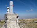
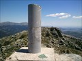
|   Oso Oso
in Vértices Geodésicos Situado en la Peña del Oso, una de las cumbres del cordal de la Mujer Muerta. posted by:  monticola monticola location: Spain date approved: 03/09/2009 last visited: never |
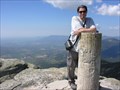
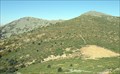 view gallery view gallery NE1.3 km NE1.3 km
|  La Pinareja La Pinareja
in Mountain Summits Forma la "cabeza" de la silueta de la Mujer Muerta. posted by: monticola location: Spain date approved: 03/09/2009 last visited: never |
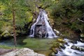
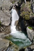
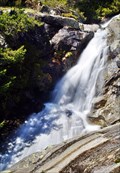
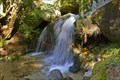 view gallery view gallerySE4.7 km |  Ducha de los Alemanes (The Shower of Germans) Ducha de los Alemanes (The Shower of Germans)
in Waterfalls Pequeña cascada de interés histórico: recibe su nombre de algunos de los primeros montañeros del Guadarrama, de origen alemán. A small waterfall with historical interest, is named after some of the first hikers of the Guadarrama, of German origin. posted by: monticola location: Comunidad de Madrid, Spain date approved: 02/28/2011 last visited: never |
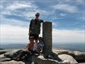
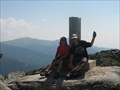 view gallery view gallery S6.3 km S6.3 km
| La Peñota (Segovia-Madrid) in Vértices Geodésicos Situado en la Sierra de Guadarrama, en la cima del pico "La Peñota", al N.O. de Cercedilla, junto a la línea de provincia de Segovia con Madrid y sobre una gran roca.
posted by: jcast location: Spain date approved: 08/10/2008 last visited: never |
 view gallery view galleryS6.3 km | Peñota in Vértices Geodésicos Situado en la Sierra de Guadarrama, en la cima del pico "La Peñota", a
unos 3.200 m. al N.O. de Cercedilla, junto a la línea de provincia de
Segovia con Madrid y sobre una gran roca. posted by: Josyto location: Castilla y León, Spain date approved: 07/03/2012 last visited: never |
 view gallery view gallery E6.6 km E6.6 km
| siete picos in Vértices Geodésicos Vertice Geodesico de Siete picos cerca de el Puerto de Navacerrada posted by: Josyto location: Comunidad de Madrid, Spain date approved: 05/25/2010 last visited: never |
 view gallery view galleryE6.6 km | Siete Picos (Madrid) in Vértices Geodésicos Situado en la Sierra de Guadarrama, en el pico más alto y al Este de la Sierra de Siete Pico posted by: jcast location: Spain date approved: 05/21/2006 last visited: 04/14/2022 |
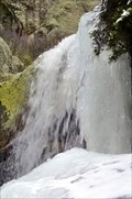
 view gallery view galleryE7.7 km | Arroyo del Venerillo in Waterfalls El arroyo del Venerillo vierte sobre el arroyo del Puerto del Paular formando esta cascada. Venerillo stream empties into the Puerto del Paular stream at this cascade. posted by: monticola location: Castilla y León, Spain date approved: 02/07/2010 last visited: never |
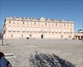 view gallery view gallery NW8.7 km NW8.7 km
|  PALACIO REAL DE RIOFRIO PALACIO REAL DE RIOFRIO
in Baroque Architecture The Royal Palace of Riofrío is one of the residences of the Spanish Royal Family, managed by the National Heritage body, which administers the State assets at the service of the Crown. posted by:  TAPIRON TAPIRON location: Castilla y León, Spain date approved: 01/04/2019 last visited: never |
 view gallery view galleryS10.6 km | Sevillana (Guadarrama / Madrid) in Vértices Geodésicos Situado en el Puerto de Guadarrama, Alto del León, sobre unas rocas y a unos 200 m de la carretera.
---
Situated at the Puerto de Guadarrama, Alto del León, on some rocks and 200 m from the road. posted by: Earendil_Muc location: Spain date approved: 07/09/2007 last visited: 03/02/2022 |
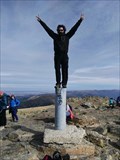
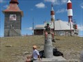 view gallery view galleryE10.6 km | Bola del Mundo in Vértices Geodésicos Vértice situado en el Alto de Guarramillas, conocido popularmente como Bola del Mundo, junto a las antenas de comunicaciones.
EL GPS me marca 2262 metros de Altura posted by: jcast location: Spain date approved: 08/20/2006 last visited: 04/12/2022 |
 view gallery view galleryE12.1 km | Maliciosa in Vértices Geodésicos Uno de los picos más conocidos de la sierra de Guadarrama. posted by: monticola location: Spain date approved: 01/09/2008 last visited: never |
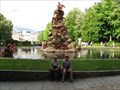 view gallery view galleryNE13 km |  Fountain of the Fame Fountain of the Fame
in Fountains The fountain of the Fame is one of the 26 monumental fountains than you can find in the gardens of the Royal Palace in "La Granja de San Ildefonso" (Segovia, Spain) posted by: jcast location: Castilla y León, Spain date approved: 05/29/2006 last visited: never |
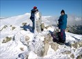
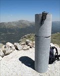
 view gallery view galleryE13.5 km | Peñalara 1993 in Vértices Geodésicos Situado en la Sierra de Guadarrama, en el pico de Peñalara, en la línea
de provincia entre Madrid y Segovia, en terreno rocoso. posted by: Josyto location: Castilla y León, Spain date approved: 04/25/2021 last visited: 09/27/2022 |
 view gallery view galleryS13.5 km | Cabeza Lijar (Guadarrama / Madrid) in Vértices Geodésicos Situado en la Sierra de Guadarrama, en el pico de Cabeza Lijar, sobre unas rocas y junto a un mirador circular con muro de piedra. posted by: Earendil_Muc location: Spain date approved: 07/09/2007 last visited: 08/19/2007 |
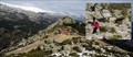 view gallery view galleryE14.3 km |  Mirador del Collado de los Pastores Mirador del Collado de los Pastores
in Orientation Tables Un grupo de cuatro paneles nos permite reconocer los lugares y cumbres más importantes de la Pedriza y Cuerda Larga.
A set of four panels gives us the ability to recognize the places and the most important summits of the Pedriza y Cuerda Larga. posted by: monticola location: Comunidad de Madrid, Spain date approved: 03/23/2010 last visited: 04/03/2010 |
 view gallery view galleryE14.5 km | Cabeza de Hierro Mayor in Vértices Geodésicos Segunda altura del Guadarrama con sus 2383 metros. posted by: monticola location: Spain date approved: 06/26/2008 last visited: never |
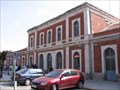 view gallery view gallery N14.5 km N14.5 km
|  Train Station - Segovia, Spain Train Station - Segovia, Spain
in Train Stations/Depots The train station in Segovia is not very big. Restrooms are available. It's about a 20 minute walk to the center of Segovia. posted by: RakeInTheCache location: Castilla y León, Spain date approved: 09/23/2007 last visited: never |
 view gallery view galleryE15.3 km | Los Chorros del Manzanares (Comunidad de Madrid) in Waterfalls Los Chorros del Manzanares son la cascada más conocida y más importante del curso alto de este río. Los Chorros del Manzanares are known and most important waterfall of the upper reaches of this river. posted by: monticola location: Comunidad de Madrid, Spain date approved: 02/16/2010 last visited: 04/03/2010 |
 view gallery view galleryNE15.8 km | Chorro Grande de San Ildefonso in Waterfalls Muy cerca del Real Sitio de La Granja el arroyo del Chorro Grande se precipita a lo largo de un gran desnivel granítico. Very close to the Real Sitio de La Granja, the stream of Chorro Grande rushes over a large granite slope. posted by: monticola location: Castilla y León, Spain date approved: 04/12/2011 last visited: never |
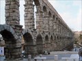 view gallery view galleryN15.9 km |  Aqueduct of Segovia - Spain Aqueduct of Segovia - Spain
in Wikipedia Entries Although not known for sure, it is thought that this ancient aqueduct was built in the 1st century AD. posted by: Metro2 location: Castilla y León, Spain date approved: 01/10/2014 last visited: 03/22/2024 |
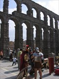 view gallery view galleryN15.9 km |  Aqueduct of Segovia Aqueduct of Segovia
in Ancient Roman Civilization The Aqueduct of Segovia is one of the most significant and best-preserved monuments left by the Romans on the Iberian Peninsula. posted by: RakeInTheCache location: Castilla y León, Spain date approved: 09/23/2007 last visited: 03/22/2024 |
 view gallery view galleryE15.9 km | Arroyo de Simón de los Chorros in Waterfalls El arroyo de Simón de los Chorros es un afluente del río Manzanares cuyo curso, de gran pendiente, presenta numerosos pequeños saltos, siendo esta una de sus mayores cascadas. posted by: monticola location: Comunidad de Madrid, Spain date approved: 04/19/2013 last visited: 04/15/2016 |
 view gallery view galleryN15.9 km |  Internetcaf.es - Segovia Internetcaf.es - Segovia
in Internet Cafes An internet cafe in the center of Segovia next to the Aqueduct. They will offer special prices according to the amount of business they have. posted by: RakeInTheCache location: Castilla y León, Spain date approved: 09/17/2007 last visited: never |
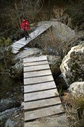 view gallery view galleryE15.9 km |  Puente del Retén Puente del Retén
in Hiking Path Footbridges El puente del Retén salva el río Manzanares en la senda de los Mesones, que sigue el río desde el puente del Francés aguas arriba. The bridge named Retén saves the banks of the Manzanares in the path of Mesones, which follows the course of river. posted by: monticola location: Comunidad de Madrid, Spain date approved: 03/23/2010 last visited: 04/15/2016 |
|