 view gallery view gallery E2.7 km E2.7 km
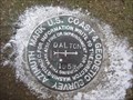
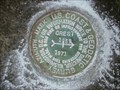
|   CC9818(DALTON AZ MK) - Sugar Creek Twp Wayne County OH CC9818(DALTON AZ MK) - Sugar Creek Twp Wayne County OH
in Azimuth Benchmarks This is the azimuth mark for USC&GS triangulation station DALTON, in Sugar Creek Township, Wayne County. posted by:  shorbird shorbird location: Ohio date approved: 12/08/2014 last visited: never |
 view gallery view gallery S3.1 km S3.1 km
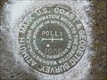
| CD2061(POLLY AZ MK) - Sugar Creek Twp Wayne County OH in Azimuth Benchmarks This is the azimuth mark for USC&GS station POLLY, in Sugar Creek Township, Wayne County. posted by: shorbird location: Ohio date approved: 11/27/2014 last visited: never |
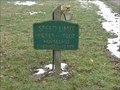
 view gallery view galleryE4.2 km |  Dalton, OH 44618 Dalton, OH 44618
in U.S. Post Offices Post office in Dalton, Wayne County, Ohio. posted by:  bitmapped bitmapped location: Ohio date approved: 08/05/2008 last visited: 11/13/2004 |
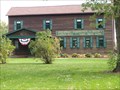
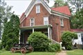
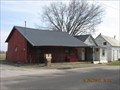
 view gallery view galleryE4.5 km |  Eagle Hotel & Tavern - 115 E Main St, Dalton, Ohio Eagle Hotel & Tavern - 115 E Main St, Dalton, Ohio
in Lincoln Highway The Eagle Hotel, built in 1821, is found at 115 E Main St in Dalton, Ohio on the Lincoln Highway. posted by: buffalohiker location: Ohio date approved: 09/07/2016 last visited: 03/06/2021 |
 view gallery view gallery W5.1 km W5.1 km
| CD2186(SUGAR AZ MK) - East Union Twp Wayne County OH in Azimuth Benchmarks This is the azimuth mark for USC&GS triangulation station SUGAR, in East Union Township, Wayne County. posted by: shorbird location: Ohio date approved: 12/09/2014 last visited: never |
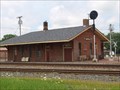 view gallery view gallery N5.1 km N5.1 km
|  Union Depot - Orrville, Ohio Union Depot - Orrville, Ohio
in Train Stations/Depots The historic Orrville Union Depot, constructed in
1868 at the crossing of the Cleveland, Akron & Columbus
and Pittsburgh, Ft. Wayne & Chicago Railroads,
serves as the headquarters of Orrville Railroad Heritage Society. posted by: buffalohiker location: Ohio date approved: 11/11/2015 last visited: 07/18/2015 |
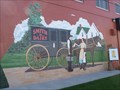 view gallery view galleryN5.5 km |  Smith Dairy murals - Orrville, Ohio Smith Dairy murals - Orrville, Ohio
in Murals Murals depicting the history of Smith Dairy. posted by: buffalohiker location: Ohio date approved: 10/19/2009 last visited: 10/11/2009 |
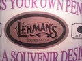 view gallery view galleryS6 km |  Lehmans Penny Smasher, Kidron Ohio Lehmans Penny Smasher, Kidron Ohio
in Penny Smashers Lehmans Hardware Store posted by: Team RAGAR location: Ohio date approved: 08/17/2009 last visited: 02/28/2013 |
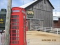 view gallery view galleryS6.1 km |  Lehman's Hardware Amish Phone Booth Lehman's Hardware Amish Phone Booth
in Red Telephone Boxes Kidron, Ohio posted by: Team RAGAR location: Ohio date approved: 04/05/2008 last visited: 04/27/2011 |
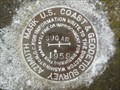
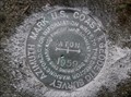
 view gallery view galleryW9.7 km | CD1867(HODGE AZ MK) - East Union Twp Wayne County OH in Azimuth Benchmarks This is the azimuth mark for USC&GS triangulation station HODGE. It is in East Union Township, Wayne County. posted by: shorbird location: Ohio date approved: 12/08/2014 last visited: never |
 view gallery view gallery NW12.1 km NW12.1 km
|  John Mishler Weaving Mill - Smithville, Ohio John Mishler Weaving Mill - Smithville, Ohio
in Mills and Gins John Mishler cloth weaving mill in Smithville, Ohio. posted by: buffalohiker location: Ohio date approved: 10/19/2009 last visited: 02/28/2013 |
 view gallery view galleryNW12.1 km |  Historic John Mishler Weaving Mill : Marker #2-85 Historic John Mishler Weaving Mill : Marker #2-85
in Ohio Historical Markers 381 Mill & 391 Home, E. Main Street in Hydnckr's hometown of Smithville, OH. posted by: BlackBrownDog location: Ohio date approved: 02/13/2006 last visited: 10/11/2009 |
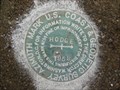
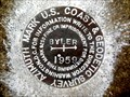 view gallery view galleryNW12.1 km | CF2690(BYLER AZ MK) - Green Twp Wayne County OH in Azimuth Benchmarks This is the azimuth mark for USC&GS triangulation station BYLER, in Green Township, Wayne County. posted by: shorbird location: Ohio date approved: 12/24/2014 last visited: never |
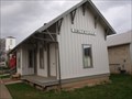 view gallery view galleryNW12.2 km | Wheeling & Lake Erie Depot - Smithville, Ohio in Train Stations/Depots Smithville Depot (1882) - Smithville, Ohio posted by: buffalohiker location: Ohio date approved: 03/23/2012 last visited: 03/18/2012 |
 view gallery view galleryS12.2 km | EATON AZ MK - Ohio in Azimuth Benchmarks This is the azimuth mark for triangulation station EATON, in Paint Township, Wayne County. posted by: shorbird location: Ohio date approved: 12/10/2011 last visited: never |
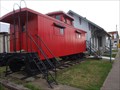 view gallery view galleryNW12.2 km |  Wooden Caboose - Smithville, Ohio Wooden Caboose - Smithville, Ohio
in Train Cabooses A wooden caboose located next to the relocated Smithville Depot in Smithville, Ohio. posted by: buffalohiker location: Ohio date approved: 03/23/2012 last visited: 03/18/2012 |
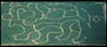 view gallery view galleryNW12.4 km |  The Barn at Smithville The Barn at Smithville
in Outdoor Mazes Located at The Barn restaurant in Smithville, Oh. posted by: 5hills location: Ohio date approved: 11/18/2009 last visited: never |
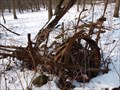
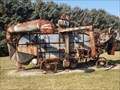 view gallery view galleryNW12.6 km |  grain separator and manure spreader - Smithville, Ohio grain separator and manure spreader - Smithville, Ohio
in Old Agricultural Equipment Huber Mfg. Co. grain separator with Hart-Carter feeder mechanism and manure spreader at Barn Restaurant in Smithville, Ohio. posted by: buffalohiker location: Ohio date approved: 02/08/2016 last visited: 02/06/2016 |
 view gallery view galleryW13.2 km | CREST AZ MK - Ohio in Azimuth Benchmarks This is the azimuth mark for triangulation station CREST, in Wooster Township, Wayne County. posted by: shorbird location: Ohio date approved: 07/03/2010 last visited: never |
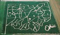 view gallery view galleryNW13.4 km | Ohio Corn Maze - Ramseyer Farm in Outdoor Mazes Located in Wayne County Ohio each year Ramseyer Farm offers two Corm Mazes, one in the shape of the State of Ohio and a mystery maze posted by: 5hills location: Ohio date approved: 11/18/2009 last visited: never |
 view gallery view galleryN14.2 km |  Ezekiel Zimmerman octagon house (1883) - Marshallville, Ohio Ezekiel Zimmerman octagon house (1883) - Marshallville, Ohio
in Octagon Buildings Ezekiel Zimmerman octagon house - 10095 Wadsworth Rd (State Route 57), Marshallville, Ohio built 1882-1883. posted by: buffalohiker location: Ohio date approved: 02/15/2016 last visited: 02/06/2016 |
 view gallery view galleryS14.5 km | WEAVER AZ MK - Ohio in Azimuth Benchmarks This is the azimuth mark for triangulation station WEAVER, in Salt Creek Township, Holmes County. It is in poor condition, with the disk missing and the stem intact. posted by: shorbird location: Ohio date approved: 12/05/2011 last visited: never |
 view gallery view galleryS14.6 km |  Farmer's Gas Station Farmer's Gas Station
in Vintage Gas Stations Amish Country, Ohio posted by: Team RAGAR location: Ohio date approved: 04/05/2008 last visited: never |
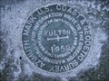 view gallery view gallery NE15 km NE15 km
| FULTON AZ MK - Lawrence Twp Stark County OH in Azimuth Benchmarks This is the azimuth mark for station FULTON. The azimuth mark is in Lawrence Township, Stark County. posted by: shorbird location: Ohio date approved: 05/08/2010 last visited: never |
 view gallery view gallery SE15.4 km SE15.4 km
| Wilderness Center corn planter, Ohio in Old Agricultural Equipment Abandoned corn planter at the Wilderness Center, Stark Co, Ohio. posted by: buffalohiker location: Ohio date approved: 01/22/2010 last visited: 01/16/2010 |
|