 view gallery view gallery S3.7 km S3.7 km
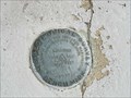
|   Long Lane Rd - Lehigh Twp (Northampton Co., PA) Survey Disk Long Lane Rd - Lehigh Twp (Northampton Co., PA) Survey Disk
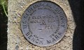
in U.S. Benchmarks U.S. Geological Survey Benchmark Disk. Couldn't find it in any searches here or on the USGS site. Stamped ET 2 AAS 1959. posted by:  Sausage! Sausage! location: Pennsylvania date approved: 10/11/2011 last visited: never |
 view gallery view gallery SW4.7 km SW4.7 km
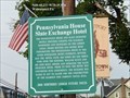
|  Pennsylvania House Slate Exchange Hotel - Walnutport PA Pennsylvania House Slate Exchange Hotel - Walnutport PA
in Signs of History The Pennsylvania House and Slate Exchange Hotels provided lodging for railroad passengers and travelers on the Lehigh Canal. posted by:  Don.Morfe Don.Morfe location: Pennsylvania date approved: 05/29/2020 last visited: 09/26/2021 |
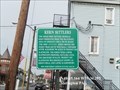
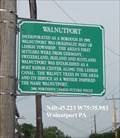 view gallery view gallerySW4.7 km | Walnutport - Walnutport PA in Signs of History Incorporated as a borough in 1909, Walnutport was originally a part of Lehigh Township. The area’s first settlers were from Germany, Switzerland, Ireland and Scotland. posted by: Don.Morfe location: Pennsylvania date approved: 05/29/2020 last visited: 09/26/2021 |
 view gallery view gallery NE4.7 km NE4.7 km
|  Blue Mountain Resort Summit Lodge - Pennsylvania Blue Mountain Resort Summit Lodge - Pennsylvania
in Web Cameras A webcam at the Summit Lodge at the Blue Mounatin Ski Resort posted by: GT.US location: Pennsylvania date approved: 03/09/2013 last visited: never |
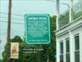 view gallery view gallerySW4.7 km | Anchor Hotel - Walnutport PA in Signs of History Built in 1834, the Anchor Hotel was a 2 ½ story, 6 bay stone building which included a 2 story double veranda. posted by: Don.Morfe location: Pennsylvania date approved: 05/29/2020 last visited: 09/26/2021 |
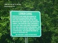 view gallery view gallerySW4.8 km | Lehigh Canal - Walnutport PA in Signs of History Completed in 1829 under the guidance of entrepreneur Josiah White, this 46 mile canal was constructed in only two years. posted by: Don.Morfe location: Pennsylvania date approved: 05/29/2020 last visited: 09/26/2021 |
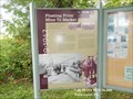 view gallery view gallerySW4.8 km | Floating From Mine to Market The Lehigh Canal - Walnutport PA in Signs of History The Lehigh Navigation, built by the Lehigh Coal and Navigation Company, was used to transport anthracite coal from mines in north eastern Pennsylvania to New York, Easton, Philadelphia, and beyond. posted by: Don.Morfe location: Pennsylvania date approved: 05/29/2020 last visited: 09/26/2021 |
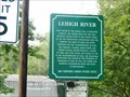 view gallery view gallerySW4.8 km | Lehigh River - Walnutport PA in Signs of History Once owned by the Lehigh Coal and Navigation Company, the Lehigh River was the only privately owned river in the United States. posted by: Don.Morfe location: Pennsylvania date approved: 05/29/2020 last visited: 09/26/2021 |
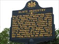 view gallery view gallerySW5 km |  Slate Industry Slate Industry
in Pennsylvania Historical Markers Sign along Main St. in Slatington, just across the bridge from Walnutport, describing the history and obvious reason for naming Slatington. posted by: Romans1116 location: Pennsylvania date approved: 08/25/2006 last visited: never |
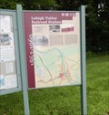 view gallery view gallerySW5 km | Lehigh Valley Railroad Station 1862 -1969 - Slatington PA in Signs of History Entrepreneur Asa Parker founded the Lehigh Valley Railroad (LVRR) in 1853 to more efficiently transport anthracite coal to market. A freight and passenger station was constructed on this site in 1862. posted by: Don.Morfe location: Pennsylvania date approved: 05/24/2020 last visited: 09/25/2021 |
 view gallery view gallerySW5 km | Kern Settlers - Slatington PA in Signs of History The areas first settler Nicholas Kern emigrated from the Palatinate area of Germany circa 1730 on board the ship Adventurer. posted by: Don.Morfe location: Pennsylvania date approved: 05/23/2020 last visited: 09/26/2021 |
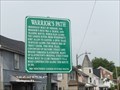 view gallery view gallerySW5.3 km | Warrior’s Path - Slatington PA in Signs of History Originally built by Indians, the Warrior’s path was a travel and trading route, which ran along the Lehigh River from Weissport’s Fort Allen to Easton. posted by: Don.Morfe location: Pennsylvania date approved: 05/23/2020 last visited: 09/26/2021 |
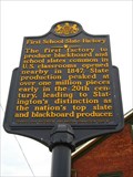 view gallery view gallerySW5.3 km | First School Slate Factory in Pennsylvania Historical Markers Near the location of the first factory to produce slates for schools. It is difficult to stop here... unless you get backed up in traffic. posted by: Romans1116 location: Pennsylvania date approved: 08/25/2006 last visited: never |
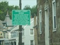 view gallery view gallerySW5.3 km | George Kern Home - Slatington PA in Signs of History Slatington’s oldest surviving home was erected in 1824 by Nicholas Kern’s grandson George. posted by: Don.Morfe location: Pennsylvania date approved: 05/23/2020 last visited: 09/26/2021 |
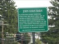 view gallery view gallerySW5.3 km | John Kern Barn - Slatington PA in Signs of History Slatington's oldest surviving structure was built circa 1807, by Nicholas Kern's grandson John. posted by: Don.Morfe location: Pennsylvania date approved: 05/24/2020 last visited: 09/26/2021 |
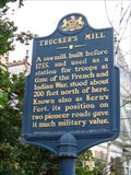 view gallery view gallerySW5.5 km | Trucker's Mill in Pennsylvania Historical Markers Trucker's Mill, a sawmill, was used as a fort during the French and Indian War. posted by: Romans1116 location: Pennsylvania date approved: 08/25/2006 last visited: never |
 view gallery view gallery NW5.5 km NW5.5 km
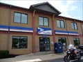
|  Palmerton, PA 18071 Palmerton, PA 18071
in U.S. Post Offices Located at 128 DELAWARE AVE FRNT PALMERTON, PA posted by: nomadwillie location: Pennsylvania date approved: 06/03/2011 last visited: 08/17/2013 |
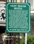 view gallery view gallerySW5.6 km | Neff House Hotel - Slatington PA in Signs of History This building was constructed in 1850 by John Remaley; whose grandfather Ambrose was an original settler to the area. posted by: Don.Morfe location: Pennsylvania date approved: 05/24/2020 last visited: 09/26/2021 |
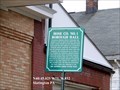 view gallery view gallerySW5.8 km | Hose Co. No. 1 Borough Hall - Slatington PA in Signs of History Slatington Borough Council purchased this property in 1888 to erect the town’s first fire station. Council decided the new building would house both the fire company and Slatington’s municipal offices. posted by: Don.Morfe location: Pennsylvania date approved: 05/24/2020 last visited: 09/26/2021 |
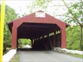 view gallery view galleryNE6.4 km |  Little Gap Covered Bridge Little Gap Covered Bridge
in Covered Bridges Covered Bridge in Carbon County posted by: Team_Zigbot location: Pennsylvania date approved: 10/23/2006 last visited: 09/18/2011 |
 view gallery view gallery W7.1 km W7.1 km
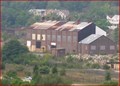
|  Palmerton Zinc - Palmerton, PA Palmerton Zinc - Palmerton, PA
in Super Fund Sites Palmerton Zinc Plant in Palmerton, PA contaminated river and mountain with zinc. posted by: Oscette location: Pennsylvania date approved: 11/16/2015 last visited: 05/03/2009 |
 view gallery view gallery SE7.1 km SE7.1 km
| MR 6 - Kreidersville, Pennsylvania in U.S. Benchmarks Benchmark disk located on curb in front of the Zion UCC Stone Church in Kreidersville, Pennsylvania. posted by:  BruceS BruceS location: Pennsylvania date approved: 08/13/2012 last visited: 11/13/2014 |
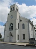 view gallery view gallerySE7.1 km |  Zion UCC Stone Church - Kreidersville, Pennsylvania Zion UCC Stone Church - Kreidersville, Pennsylvania
in This Old Church Historic church in Kreidersville, Pennsylvania. posted by: BruceS location: Pennsylvania date approved: 08/13/2012 last visited: 11/13/2014 |
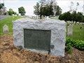 view gallery view gallerySE7.1 km |  Zion UCC Stone Church Cemetery Revolutionary War Memorial - Kreidersville, Pennsylvania Zion UCC Stone Church Cemetery Revolutionary War Memorial - Kreidersville, Pennsylvania
in U.S. Revolutionary War Memorials Memorial placed to honor the more than 60 Revolutionary War veterans buried at the Zion UCC Stone Church Cemetery in Kreidersville, Pennsylvania. posted by: BruceS location: Pennsylvania date approved: 08/13/2012 last visited: 07/11/2017 |
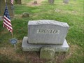 view gallery view gallerySE7.1 km |  Johann Michael Kressler - Kreidersville, Pennsylvania Johann Michael Kressler - Kreidersville, Pennsylvania
in American Revolutionary War Veteran Graves Grave of Revolutionary War veteran at the Zion UCC Stone Church Cemetery in Kreidersville, Pennsylvania. posted by: BruceS location: Pennsylvania date approved: 08/07/2012 last visited: 11/13/2014 |
|