 view gallery view gallery W18.3 km W18.3 km
|   Buffalo - Atwood, Kansas Buffalo - Atwood, Kansas
in School Mascots The Atwood Buffalo is the mascot for the Rawlins County High School sports teams - in Atwood, Kansas. posted by:  The Snowdog The Snowdog location: Kansas date approved: 01/08/2021 last visited: never |
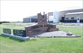
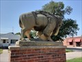 view gallery view galleryW18.3 km |  Atwood Buffalo - Atwood, KS Atwood Buffalo - Atwood, KS
in Figurative Public Sculpture The Atwood Buffalo stands watch from the median of Main Street near the Rawlins County Courthouse in Atwood, Kansas. posted by: The Snowdog location: Kansas date approved: 01/09/2021 last visited: never |
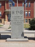 view gallery view galleryW18.3 km |  Rawlins County Veterans Memorial - Atwood, KS Rawlins County Veterans Memorial - Atwood, KS
in Non-Specific Veteran Memorials The Rawlins County Veterans Memorial is on the south side of the Rawlins County Courthouse in Atwood, Kansas. posted by: The Snowdog location: Kansas date approved: 01/09/2021 last visited: never |
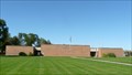
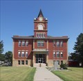 view gallery view galleryW18.3 km |  Rawlins County Courthouse - Atwood, KS Rawlins County Courthouse - Atwood, KS
in Courthouses This 1907 courthouse serves Rawlins County; in Atwood, Kansas. posted by: The Snowdog location: Kansas date approved: 01/10/2021 last visited: never |
 view gallery view galleryW18.3 km |  KH0298 B 78 1934 - Atwood, KS KH0298 B 78 1934 - Atwood, KS
in U.S. Benchmarks This U.S. Coast and Geodetic Survey Benchmark Disk is set in the southwest corner of the Rawlins County Courthouse in Atwood, Kansas. posted by: The Snowdog location: Kansas date approved: 01/08/2021 last visited: never |
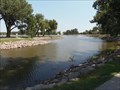 view gallery view galleryW18.5 km |  Atwood Lake-Through the Looking Glass - Atwood, Kansas, USA Atwood Lake-Through the Looking Glass - Atwood, Kansas, USA
in Natural Lakes This waymark is for Atwood Lake in Atwood, Kansas. posted by:  OceanicCrew815 OceanicCrew815 location: Kansas date approved: 08/16/2018 last visited: 08/06/2020 |
 view gallery view galleryW18.7 km |  Atwood Lake Covered Bridge- Lost Series of Waymarks Atwood Lake Covered Bridge- Lost Series of Waymarks
in Covered Bridges This is a covered bridge that is located at the Atwood Lake. posted by: OceanicCrew815 location: Kansas date approved: 08/16/2018 last visited: 08/06/2020 |
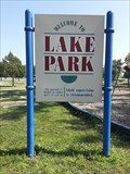 view gallery view galleryW18.7 km |  Atwood Lake Park - Atwood, KS Atwood Lake Park - Atwood, KS
in Municipal Parks and Plazas Atwood Lake Park is on the south side of Atwood Lake in Atwood, Kansas. posted by: The Snowdog location: Kansas date approved: 01/08/2021 last visited: never |
 view gallery view galleryW18.8 km |  Atwood Lake Park - Atwood, KS Atwood Lake Park - Atwood, KS
in Public Playgrounds This fine public playground is in Atwood Lake Park, on the south side of Atwood Lake in Atwood, Kansas. posted by: The Snowdog location: Kansas date approved: 01/07/2021 last visited: never |
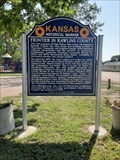 view gallery view galleryW18.8 km |  Frontiers in Rawlins County - Atwood, KS Frontiers in Rawlins County - Atwood, KS
in Kansas Historical Markers This Kansas Historical Marker, describing the history of Rawlins County, is in Atwood Lake Park in Atwood, Kansas. posted by: The Snowdog location: Kansas date approved: 01/09/2021 last visited: never |
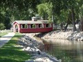
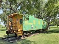 view gallery view galleryW18.8 km |  CB&Q Caboose 10405, Atwood, KS CB&Q Caboose 10405, Atwood, KS
in Train Cabooses This Chicago, Burlington, and Quincy Railroad Caboose is on display near the old CB&Q Depot, northwest of Lake Atwood in Atwood, Kansas. posted by: The Snowdog location: Kansas date approved: 01/07/2021 last visited: never |
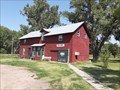
 view gallery view galleryW19 km |  Chicago, Burlington, and Quincy Depot - Atwood, KS Chicago, Burlington, and Quincy Depot - Atwood, KS
in Relocated Structures The Atwood Chicago, Burlington, and Quincy Depot has been relocated to the northwest side of Lake Atwood - in Atwood, Kansas. posted by: The Snowdog location: Kansas date approved: 01/07/2021 last visited: never |
 view gallery view gallery E24.9 km E24.9 km
|  Oberlin Municipal Airport - Oberlin, KS Oberlin Municipal Airport - Oberlin, KS
in Airports Oberlin Municipal Airport is located in the city of Oberlin, Kansas. posted by: oiseau_ca location: Kansas date approved: 01/15/2016 last visited: never |
 view gallery view gallery SW24.9 km SW24.9 km
|  Chicago, Burlington, and Quincy Depot - Atwood, KS Chicago, Burlington, and Quincy Depot - Atwood, KS
in Train Stations/Depots The Atwood Chicago, Burlington, and Quincy Depot, once in downtown Atwood, has been relocated to the northwest side of Lake Atwood - in Atwood, Kansas. posted by: The Snowdog location: Kansas date approved: 01/09/2021 last visited: never |
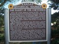 view gallery view galleryE26.4 km | The Flight of the Cheyennes in Kansas Historical Markers Historical marker about the escape and flight of a group of Cheyennes from a reservation to their homeland. posted by: Prying Pandora location: Kansas date approved: 05/23/2007 last visited: 05/07/2021 |
 view gallery view gallery NE30.7 km NE30.7 km
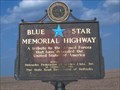
|  Highway 83, South Nebraska Highway 83, South Nebraska
in Blue Star Memorial Highway Markers Blue Star Highway sign on Highway 83 in Southern Nebraska posted by: Prying Pandora location: Nebraska date approved: 05/27/2007 last visited: 05/07/2012 |
 view gallery view gallery N33.3 km N33.3 km
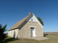
|  St. Paul's Methodist Protestant Church Also known as The Stone Church St. Paul's Methodist Protestant Church Also known as The Stone Church
in U.S. National Register of Historic Places This stone church was built in 1900 and used for services until 1951. posted by:  NevaP NevaP location: Nebraska date approved: 10/06/2008 last visited: never |
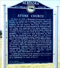 view gallery view galleryN35.4 km |  Stone Church Stone Church
in Nebraska Historical Markers A historic stone church is preserved at this site. posted by: NevaP location: Nebraska date approved: 10/05/2008 last visited: never |
 view gallery view gallery SE40.1 km SE40.1 km
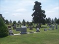
|  Dresden Cemetery - Dresden, KS Dresden Cemetery - Dresden, KS
in Worldwide Cemeteries Located in a small Northwestern town in Kansas. posted by: mr.volkswagen location: Kansas date approved: 07/18/2007 last visited: never |
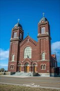 view gallery view gallerySE40.6 km |  Immaculate Conception Catholic Church - Leoville, KS Immaculate Conception Catholic Church - Leoville, KS
in Roman Catholic Churches Located in the heart of Leoville, KS. In fact this is the largest building in the town. posted by: mr.volkswagen location: Kansas date approved: 02/29/2020 last visited: 02/28/2020 |
 view gallery view gallerySE40.6 km |  1885 - Immaculate Conception Catholic Church - Leoville, KS 1885 - Immaculate Conception Catholic Church - Leoville, KS
in Dated Buildings and Cornerstones Located in the heart of Leoville, KS. In fact this is the largest building in the town. posted by: mr.volkswagen location: Kansas date approved: 03/08/2020 last visited: never |
 view gallery view galleryN43.3 km | Hitchcock County Courthouse, Trenton, Nebraska in Courthouses This brick courthouse was built in 1969 posted by: NevaP location: Nebraska date approved: 10/18/2008 last visited: never |
 view gallery view gallery NW44.4 km NW44.4 km
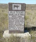
| Old Texas Ogallala Trail in Nebraska Historical Markers This stone marker stands on the route of a major Texas to Nebraska cattle trail. posted by: NevaP location: Nebraska date approved: 10/05/2008 last visited: 05/03/2015 |
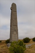 view gallery view galleryN45.2 km |  Massacre Canyon Battlefield Memorial - Trenton, NE Massacre Canyon Battlefield Memorial - Trenton, NE
in Obelisks A monument erected in 1930 to commemorate the Massacre Canyon Battle between the Pawnee and the Sioux. The monument stands 35 feet tall and weighs over 90 tons. posted by: IJAdventures location: Nebraska date approved: 10/12/2012 last visited: 05/08/2012 |
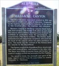 view gallery view galleryN45.2 km | Massacre Canyon in Nebraska Historical Markers The marker stands near the site of the 1873 final battle between Pawnee and Sioux tribes in Nebraska. posted by: NevaP location: Nebraska date approved: 10/05/2008 last visited: 05/08/2012 |
|