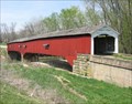
 view gallery view gallery E1.1 km E1.1 km
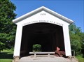
|   Melcher Covered Bridge - Parke County, Indiana Melcher Covered Bridge - Parke County, Indiana
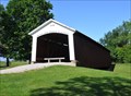
in Covered Bridges A short bridge with a lot of names--also known as Klondyke Bridge, Marion Bridge, and Leatherwood Bridge. posted by:  GwynEvie GwynEvie location: Indiana date approved: 04/26/2009 last visited: 10/02/2014 |
 view gallery view gallery S2.1 km S2.1 km
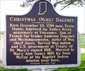
|  Christmas (Noel) Dagenet Christmas (Noel) Dagenet
in Indiana Historical Markers A marker describing the life of Christmas Dagenet. posted by: GwynEvie location: Indiana date approved: 04/26/2009 last visited: 01/22/2011 |
 view gallery view gallery SE2.1 km SE2.1 km
| Sim Smith Covered Bridge - Parke County, Indiana in Covered Bridges An early effort by noted covered bidge builder Joseph A. Britton. posted by: GwynEvie location: Indiana date approved: 04/26/2009 last visited: 10/02/2014 |
 view gallery view gallery W2.3 km W2.3 km
|  Montezuma, Indiana 47862 Montezuma, Indiana 47862
in U.S. Post Offices This Post Office is located at 982 N Washington Street in Montezuma, Indiana. posted by: brwhiz location: Indiana date approved: 07/15/2013 last visited: never |
 view gallery view gallerySE2.7 km | Phillips Covered Bridge - Parke County, Indiana in Covered Bridges The shortest covered bridge in Parke County, and the only one not built with a Burr Arch truss. posted by: GwynEvie location: Indiana date approved: 04/26/2009 last visited: 10/02/2014 |
 view gallery view galleryS2.9 km | Armiesburg in Indiana Historical Markers This marker designates the site where U.S. armies camped during conflicts in 1811 and 1812. posted by: GwynEvie location: Indiana date approved: 04/26/2009 last visited: 01/22/2011 |
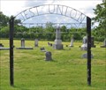 view gallery view gallery N6.4 km N6.4 km
|  West Union Cemetery West Union Cemetery
in Worldwide Cemeteries This Cemetery is located on the northwest side of Tow Path Road on the northeast edge of West Union, Indiana. posted by: brwhiz location: Indiana date approved: 07/15/2013 last visited: never |
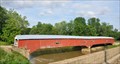
 view gallery view galleryN7.4 km | West Union Covered Bridge - Parke County, Indiana in Covered Bridges The longest covered bridge in Parke County, Indiana, which claims to be the covered bridge capital of the world. posted by: GwynEvie location: Indiana date approved: 04/26/2009 last visited: 10/16/2020 |
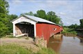
 view gallery view galleryN7.4 km |  West Union Bridge ~ West Union, Indiana West Union Bridge ~ West Union, Indiana
in U.S. National Register of Historic Places The West Union Bridge was placed on the National Register of Historic Places on December 22, 1978 (#78000414). posted by: brwhiz location: Indiana date approved: 07/12/2013 last visited: 10/16/2020 |
 view gallery view galleryN7.4 km |  West Union Covered Bridge West Union Covered Bridge
in Orphaned Bridges This Orphaned Bridge crosses Sugar Creek parallel to Tow Path Road about 0.8 miles north of West Union, Indiana. This bridge is on the National Register of Historic Places. posted by: brwhiz location: Indiana date approved: 07/16/2013 last visited: 10/16/2020 |
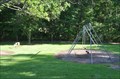 view gallery view galleryW9 km |  Ernie Pyle Rest Park Playground Ernie Pyle Rest Park Playground
in Public Playgrounds This Public Playground is located in the Ernie Pyle Rest Park on the north side of US Highway 36 about 4.5 miles west of Montezuma, Indiana. posted by: brwhiz location: Indiana date approved: 07/14/2013 last visited: 10/29/2021 |
 view gallery view galleryW9 km |  Ernie Pyle Rest Park Ernie Pyle Rest Park
in Highway Rest Areas This Highway Rest Area is located on the north side of US Highway 36 about 2.2 miles east of Dana, Indiana. posted by: brwhiz location: Indiana date approved: 07/14/2013 last visited: 10/29/2021 |
 view gallery view galleryW9.2 km | Hillsdale/Possum Bottom/Jackson's Ford Covered Bridge in Covered Bridges This Covered Bridge has been relocated from its original site and now is located in the Ernie Pyle Rest Park on the north side of US Highway 36 about 4.5 miles west of Montezuma, Indiana. This bridge is on the National Register of Historic Places. posted by: brwhiz location: Indiana date approved: 07/17/2013 last visited: 10/29/2021 |
 view gallery view galleryW9.2 km | Possom Bottom Covered Bridge ~ Dana, Indiana in U.S. National Register of Historic Places The Possom Bottom/Jackson's Ford/Hillsdale Covered Bridge was placed on the National Register of Historic Places on June 10, 1994 (#94000584). posted by: brwhiz location: Indiana date approved: 07/14/2013 last visited: 10/29/2021 |
 view gallery view galleryW9.2 km | Hillsdale/Possum Bottom/Jackson's Ford Covered Bridge in Orphaned Bridges This Covered Bridge has been relocated from its original site and now is located in the Ernie Pyle Rest Park on the north side of US Highway 36 about 4.5 miles west of Montezuma, Indiana. This bridge is on the National Register of Historic Places. posted by: brwhiz location: Indiana date approved: 07/16/2013 last visited: 10/29/2021 |
 view gallery view galleryE9.3 km | Catlin Covered Bridge in Orphaned Bridges This Orphaned Bridge crosses Big Diddle Creek on the Parke County Golf Course at 1640 N US Highway 41 north of Rockville, Indiana. This bridge is on the National Register of Historic Places. It now serves as a golf cart crossing for the golf course. posted by: brwhiz location: Indiana date approved: 07/16/2013 last visited: 10/16/2020 |
 view gallery view galleryE9.3 km | Catlin Bridge ~ Rockville, Indiana in U.S. National Register of Historic Places The Catlin Bridge was placed on the National Register of Historic Places on December 22, 1978 (#78000387). posted by: brwhiz location: Indiana date approved: 07/12/2013 last visited: 10/16/2020 |
 view gallery view galleryE9.3 km | Catlin Covered Bridge in Covered Bridges This Covered Bridge crosses Big Diddle Creek on the Parke County Golf Course at 1640 N US Highway 41 north of Rockville, Indiana. This bridge is on the National Register of Historic Places. posted by: brwhiz location: Indiana date approved: 07/17/2013 last visited: 10/16/2020 |
 view gallery view galleryE9.3 km |  Parke County Golf Course Parke County Golf Course
in Public and Private Golf Courses This Golf Course is located at 1640 N US Highway 41 north of Rockville, Indiana. posted by: brwhiz location: Indiana date approved: 07/11/2013 last visited: 10/16/2020 |
 view gallery view galleryE9.5 km |  Scott Pet Products Grain Elevator Scott Pet Products Grain Elevator
in Grain Elevators This Grain Elevator is located at 1543 N US Highway 41 in Rockville, Indiana. posted by: brwhiz location: Indiana date approved: 07/31/2013 last visited: never |
 view gallery view galleryE9.7 km |  Subway - Rockville, IN Subway - Rockville, IN
in Subway Restaurants This Subway restaurant is in Rockville, Indiana. posted by: The Snowdog location: Indiana date approved: 06/22/2023 last visited: never |
 view gallery view galleryE9.8 km | Memory Garden in Worldwide Cemeteries This Cemetery is located at approximately 1096 N Lincoln Road (US Highway 41) in Rockville, Indiana. posted by: brwhiz location: Indiana date approved: 07/15/2013 last visited: never |
 view gallery view galleryE10 km | Juliet V. Strauss - Rockville, Indiana in Indiana Historical Markers Installed 2012 Indiana Historical Bureau, Rockville Public Library, Parke County Historical Society, and Friends of Turkey Run posted by: Rattrak location: Indiana date approved: 11/22/2018 last visited: never |
 view gallery view galleryE10.1 km | Parke County Museum in Indiana Historical Markers Indiana Historical Marker for the Parke County Museum posted by: Rinkey location: Indiana date approved: 04/29/2006 last visited: 10/16/2020 |
 view gallery view galleryE10.1 km |  Parke County Historical Society Museum Parke County Historical Society Museum
in History Museums This History Museum is located at 503 W Ohio Street in Rockville, Indiana. posted by: brwhiz location: Indiana date approved: 07/11/2013 last visited: 10/16/2020 |
|