 view gallery view gallery S2.9 km S2.9 km
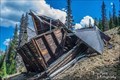
|   Allie Belle Mine - Chaffee County, CO Allie Belle Mine - Chaffee County, CO
in Mines Located along forest service road 295. posted by:  mr.volkswagen mr.volkswagen location: Colorado date approved: 01/14/2021 last visited: never |
 view gallery view gallery NE3.7 km NE3.7 km
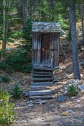
|  St. Elmo Outhouse - St. Elmo, CO St. Elmo Outhouse - St. Elmo, CO
in Outhouses Just offmain St. between two buildings on the south west part of town. posted by: mr.volkswagen location: Colorado date approved: 10/31/2020 last visited: never |
 view gallery view gallery NW3.7 km NW3.7 km
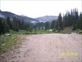
|  Tin Cup Pass Tin Cup Pass
in Free Campsites A beautiful undeveloped National Forest camping area. posted by:  Rythmguy1 Rythmguy1 location: Colorado date approved: 06/21/2008 last visited: never |
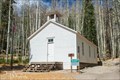 view gallery view galleryNE3.9 km |  St. Elmo School House - St. Elmo, CO St. Elmo School House - St. Elmo, CO
in One-Room Schoolhouses The St. Elmo School House in on the north side of St. Elmo. posted by: mr.volkswagen location: Colorado date approved: 10/31/2020 last visited: never |
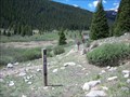 view gallery view galleryNW4.3 km |  Tunnel Lake Trail at Tin Cup Pass Road Trailhead - San Isabel National Forest; Chaffee County, CO Tunnel Lake Trail at Tin Cup Pass Road Trailhead - San Isabel National Forest; Chaffee County, CO
in Hiking and walking trailheads A segment of the Continental Divide Trail (#1439) in the San Isabel National Forest. posted by: cldisme location: Colorado date approved: 11/03/2010 last visited: never |
 view gallery view gallery SW4.3 km SW4.3 km
|  Alpine Tunnel Alpine Tunnel
in Abandoned Train Tunnels Alpine Tunnel is one of the few tunnels that bisects the continental divide. posted by: biketothetop and pinklady location: Colorado date approved: 11/03/2006 last visited: 08/08/2015 |
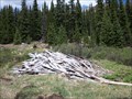 view gallery view galleryNW4.5 km |  Wilderness Cabin - San Isabel National Forest; Chaffee County, CO Wilderness Cabin - San Isabel National Forest; Chaffee County, CO
in Remains of Settlements The collapsed remains of a cabin in the upper elevations of the Rocky Mountains posted by: cldisme location: Colorado date approved: 11/07/2010 last visited: never |
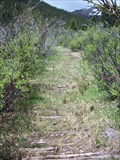 view gallery view galleryNW4.5 km |  Wilderness Plank Road - San Isabel National Forest; Chaffee County, Colorado Wilderness Plank Road - San Isabel National Forest; Chaffee County, Colorado
in Plank Roads The remains of plank trail along the Continental Divide Trail. posted by: cldisme location: Colorado date approved: 10/15/2010 last visited: never |
 view gallery view gallerySW5 km |  Alpine Tunnel Historic District - Pitkin, CO Alpine Tunnel Historic District - Pitkin, CO
in U.S. National Register of Historic Places The Alpine Tunnel Historic District incorporates 13 miles of the original Denver, South Park and Pacific Railroad. The tunnel itself was the first constructed through the Continental Divide and began service in 1882. posted by: IJAdventures location: Colorado date approved: 02/02/2013 last visited: 08/08/2015 |
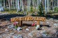
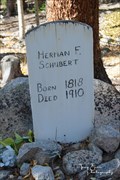 view gallery view galleryNE5.1 km |  Herman F. Schubert - Iron City Cemetery - Chaffee County, CO Herman F. Schubert - Iron City Cemetery - Chaffee County, CO
in Homemade Tombstones Located in the Iron City Cemetery near St. Elmo, CO. posted by: mr.volkswagen location: Colorado date approved: 10/31/2020 last visited: never |
 view gallery view galleryNE5.1 km |  Iron City Cemetery - Chaffee County, CO Iron City Cemetery - Chaffee County, CO
in Worldwide Cemeteries This cemetery is located just outside the old mining town of St. Elmo
from State Hwy 285 go west on County Rd 162 approx 14.5 miles.
The cemetery sits just past Iron City campground posted by: mr.volkswagen location: Colorado date approved: 10/30/2020 last visited: never |
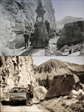 view gallery view galleryS6 km |  Split Rock - Alpine Tunnel Historic District - Pitkin, CO Split Rock - Alpine Tunnel Historic District - Pitkin, CO
in Photos Then and Now Excursion train at "Split Rock" in 1889. This prominent landmark is located near the palisades on the old Denver, South Park and Pacific railroad grade to the historic Alpine Tunnel. posted by: IJAdventures location: Colorado date approved: 07/27/2012 last visited: 08/08/2015 |
 view gallery view galleryS6 km |  Hancock Pass, CO (12,140) Hancock Pass, CO (12,140)
in Elevation Signs Located on the Continental Divide on Forest Service road 299. posted by: mr.volkswagen location: Colorado date approved: 07/28/2018 last visited: 08/06/2018 |
 view gallery view gallery W10 km W10 km
| Cumberland Pass, Gunnison County, CO. 12015 ft in Elevation Signs The Cumberland pass is 18 miles in length going between between Pitkin and Tincup Colorado. Never needed 4WD, but a high clearance vehicle would probably be wise. posted by: LT_Dream location: Colorado date approved: 09/08/2015 last visited: never |
 view gallery view gallery E10.8 km E10.8 km
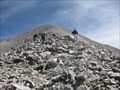
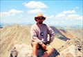
|  Mt Antero, CO Mt Antero, CO
in Mountain Summits Mount Antero is the tenth highest peak in Colorado, with an elevation of 14,269 feet. posted by: TucsonThompsen location: Colorado date approved: 06/03/2010 last visited: never |
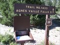 view gallery view galleryE12.7 km |  San Isabel National Forest Trail #1433 Trailhead; Agnes Valle Falls - Chaffee County, CO San Isabel National Forest Trail #1433 Trailhead; Agnes Valle Falls - Chaffee County, CO
in Trail Registers A register at the trailhead to the Agnes Valle Falls. posted by: cldisme location: Colorado date approved: 11/19/2010 last visited: never |
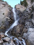 view gallery view galleryNE12.9 km |  Agnes Vaille Falls - San Isabel National Forest; Chaffee County, CO Agnes Vaille Falls - San Isabel National Forest; Chaffee County, CO
in Waterfalls A fast flowing waterfall at the base of Mount Princeton. posted by: cldisme location: Colorado date approved: 10/18/2010 last visited: 04/02/2012 |
 view gallery view gallery SE12.9 km SE12.9 km
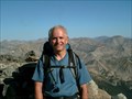
| Mount Shavano in Mountain Summits Mount Shavano is the 17th highest point in the state of Colorado and the southern and easternmost 14er in the Sawatch range of the Rocky Mountains. In the spring and early summer, the "Angel of Shavano" is visible on the east face of the mountain. posted by: DrPowercat location: Colorado date approved: 09/07/2009 last visited: 08/09/2008 |
 view gallery view galleryNE13.8 km | Princeton, Mount in Mountain Summits Beatiful view of the Collegiate Peaks from here. posted by: t-xman location: Colorado date approved: 09/09/2005 last visited: 07/18/2001 |
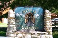 view gallery view gallerySW15.3 km | 9241 Feet - Pitkin, CO in Elevation Signs Welcome to Pitkin, Colorado; Alt: 9241; Pop: Strange posted by: IJAdventures location: Colorado date approved: 11/10/2010 last visited: 09/08/2015 |
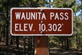 view gallery view gallerySW16.3 km | 10,302 Feet - Waunita Pass, CO in Elevation Signs Summit of Waunita Pass (Elev. 10,302') between Pitkin and Waunita Hot Springs posted by: IJAdventures location: Colorado date approved: 09/21/2010 last visited: 11/28/2012 |
 view gallery view gallery N17.4 km N17.4 km
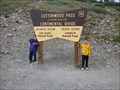
| Cottonwood Pass on the Continental Divide in Elevation Signs This sign is at a parking lot on top of the pass. posted by: DrPowercat location: Colorado date approved: 09/07/2009 last visited: 10/03/2021 |
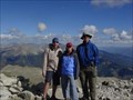
 view gallery view galleryN19.5 km | Mount Yale in Mountain Summits One of the Collegiate peaks which is surrounded by Mt Harvard, Mt Columbia, and Mt Princeton.
posted by: t-xman location: Colorado date approved: 09/08/2005 last visited: 09/01/2013 |
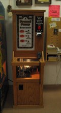 view gallery view galleryS20.1 km |  Monarch Crest Gift Shop; CO Monarch Crest Gift Shop; CO
in Penny Smashers A 3-die electric machine located in the Monarch Crest Gift Shop. posted by: skree location: Colorado date approved: 08/13/2007 last visited: 09/15/2014 |
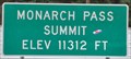 view gallery view galleryS20.3 km | Monarch Pass Summit ~ Elevation 11,312 Feet in Elevation Signs This Elevation Sign is located on the east side of US Highway 50 at the summit of Monarch Pass between Salida and Gunnison, Colorado. posted by: brwhiz location: Colorado date approved: 02/12/2013 last visited: 09/15/2014 |
|