 view gallery view gallery W3.5 km W3.5 km
|   Battle of Trevilian Station - Louisa VA Battle of Trevilian Station - Louisa VA
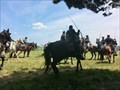
in Historic Reenactments The Battle of Trevilian Station reenactment took place on June 9-10, 2012 at Louisa VA. This was a living history event. This reenactment included both Union and Confederate Cavalry on horse back simulating the battle. posted by:  Don.Morfe Don.Morfe location: Virginia date approved: 01/15/2022 last visited: 01/13/2022 |
 view gallery view gallery NE4.8 km NE4.8 km
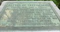
|  Battle of Trevillians - Louisa VA Battle of Trevillians - Louisa VA
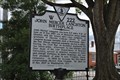
in U.S. Civil War Sites — Fought here June 11, 12, 1864 —Greatest all-cavalry battle of the war. Signal Confederate victory posted by: Don.Morfe location: Virginia date approved: 07/28/2020 last visited: 10/04/2021 |
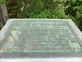 view gallery view galleryNE4.8 km |  Battle of Trevillians - Louisa VA Battle of Trevillians - Louisa VA
in Battlefields Fought here June 11, 12, 1864 —
Confederate Gens. Wade Hampton, Fitzhugh Lee
and Thomas L. Rosser, victors over
Federal Gens. P.H. Sheridan and G.A. Custer posted by: Don.Morfe location: Virginia date approved: 11/21/2020 last visited: 10/16/2021 |
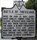 view gallery view galleryNE4.8 km |  Battle of Trevilians Battle of Trevilians
in Virginia Historical Markers US Civil War battle posted by:  vhasler vhasler location: Virginia date approved: 09/09/2011 last visited: 10/02/2012 |
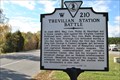 view gallery view galleryNE5 km | Trevilian Station Battle in Virginia Historical Markers This historic marker stands on Route 33 near the community of Trevilian in Louisa County, Virginia posted by: Sneakin Deacon location: Virginia date approved: 11/21/2010 last visited: 10/02/2012 |
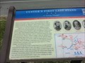
 view gallery view galleryNE5 km | Custer's First Last Stand A "Living Triangle" - Louisa VA in Civil War Discovery Trail Sites Nearby stood Trevilian Station, south of which Confederate Gen. Wade Hampton had parked his wagon train on the evening of June 10, 1864. posted by: Don.Morfe location: Virginia date approved: 07/24/2020 last visited: 10/05/2021 |
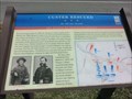 view gallery view galleryNE5 km | Custer Rescued-An All-out Assault - Louisa VA in U.S. Civil War Sites By mid-morning on June 11, 1864, Gen. George A. Custer's attack on Confederate Gen. Wade Hampton's wagon train here had gone from success to near disaster as Southern cavalry surrounded Custer's force. posted by: Don.Morfe location: Virginia date approved: 06/29/2023 last visited: 06/29/2023 |
 view gallery view galleryNE5 km | Custer's First Last Stand-A "Living Triangle" - Louisa VA in U.S. Civil War Sites About 8 a.m., Union Gen. George A. Custer's Michigan Brigade turned west onto the Gordonsville Road from the Nunn's Creek Road at Mildred Crossing, with Col. Russell A. Alger's 5th Michigan Cavalry leading the way. posted by: Don.Morfe location: Virginia date approved: 06/29/2023 last visited: 06/29/2023 |
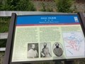 view gallery view galleryNE5 km | Ogg Farm-Repulsed with Heavy Losses - Louisa VA in U.S. Civil War Sites he apex of that line became known as the Bloody Angle during the heavy fighting later that day. Col. Richard. H. Dulany’s and Col. Gilbert J. Wright’s brigades supported the South Carolinians and extended the line past the Ogg House. posted by: Don.Morfe location: Virginia date approved: 06/29/2023 last visited: 06/29/2023 |
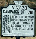
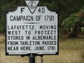 view gallery view galleryW6.3 km | Campaign of 1781 in Virginia Historical Markers Located on highway 15. posted by: MNSearchers location: Virginia date approved: 09/06/2008 last visited: 01/12/2019 |
 view gallery view gallery NW6.9 km NW6.9 km
|  Boswell's Tavern - Louisa County, VA Boswell's Tavern - Louisa County, VA
in U.S. National Register of Historic Places A 18th century tavern serving famous Revolutionary era folks, including Jefferson, Henry, and Madison. posted by: vhasler location: Virginia date approved: 01/22/2011 last visited: 10/06/2011 |
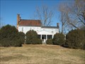 view gallery view galleryNW6.9 km |  Boswell's Tavern - Louisa County, VA Boswell's Tavern - Louisa County, VA
in American Guide Series Boswell's Tavern was an early "hotel" serving travelers passing through central Virginia posted by: vhasler location: Virginia date approved: 01/22/2011 last visited: never |
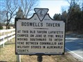 view gallery view galleryNW6.9 km | Boswell's Tavern in Virginia Historical Markers 18th century tavern serving famous Revolutionary era folks, including Jefferson, Henry, and Madison. posted by: vhasler location: Virginia date approved: 01/30/2011 last visited: 10/06/2011 |
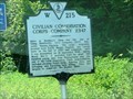 view gallery view galleryNW6.9 km |  Civilian Conservation Corps Company 2347 - Louisa VA Civilian Conservation Corps Company 2347 - Louisa VA
in Civilian Conservation Corps Civilian Conservation Corps Company 2347 is located on Louisa Road, State Route 22 in Louisa VA. posted by: Don.Morfe location: Virginia date approved: 02/12/2024 last visited: 02/12/2024 |
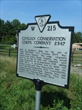 view gallery view galleryNW6.9 km | Civilian Conservation Corps Company 2347 in Virginia Historical Markers Virginia Historical Highway Marker W-215 posted by: garmin_geek location: Virginia date approved: 08/24/2010 last visited: 02/12/2024 |
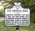 view gallery view galleryNW7.1 km | The Marquis Road in Virginia Historical Markers A road opened up by Lafayette in 1781 posted by: Taluss location: Virginia date approved: 09/25/2008 last visited: 10/12/2014 |
 view gallery view gallery E10.6 km E10.6 km
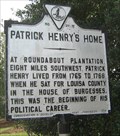
| Patrick Henry's Home in Virginia Historical Markers Patrick Henry was from Louisa County posted by: vhasler location: Virginia date approved: 07/24/2011 last visited: 10/26/2011 |
 view gallery view galleryE10.6 km | Louisa County Courthouse - Louisa, Virginia in U.S. National Register of Historic Places The Louisa County Courthouse stands on the courthouse square at the center of Louisa, Virginia posted by: Sneakin Deacon location: Virginia date approved: 11/11/2010 last visited: 08/24/2012 |
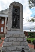 view gallery view galleryE10.6 km | Louisa County Confederate Memorial - Louisa Virginia in American Civil War Monuments and Memorials The Louisa County Confederate Memorial stands on the grounds of the Louisa County Courthouse. posted by: Sneakin Deacon location: Virginia date approved: 11/15/2010 last visited: 08/18/2012 |
 view gallery view galleryE10.6 km |  Louisa County Courthouse - Louisa, Virginia Louisa County Courthouse - Louisa, Virginia
in Courthouses The Louisa County Courthouse is located in the historic town of Louisa, Virginia posted by: Sneakin Deacon location: Virginia date approved: 11/15/2010 last visited: 10/02/2012 |
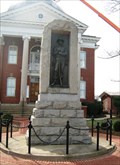 view gallery view galleryE10.6 km |  Confederate Monument - Louisa, VA Confederate Monument - Louisa, VA
in Smithsonian Art Inventory Sculptures Confederate soldier as a bronze relief sculpture set in a granite block. Located on the courthouse grounds. posted by: vhasler location: Virginia date approved: 12/17/2011 last visited: 10/02/2012 |
 view gallery view galleryE10.6 km | John Mercer Langston in Virginia Historical Markers This historic marker stands on the grounds of the Louisa County Courthouse in Louisa, Virginia. posted by: Sneakin Deacon location: Virginia date approved: 10/17/2010 last visited: 08/18/2012 |
 view gallery view gallery SW10.6 km SW10.6 km
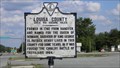
| Louisa County Historical Maker in Virginia Historical Markers This is a Virginia Historical Marker for Louisa County. posted by: 79scouts location: Virginia date approved: 07/24/2011 last visited: 07/22/2020 |
 view gallery view gallery S10.8 km S10.8 km
| Campaign of 1781 in Virginia Historical Markers Plaque in front of large rural church posted by: johnjm99 location: Virginia date approved: 02/25/2006 last visited: 07/03/2012 |
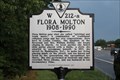 view gallery view gallerySW10.8 km | Flora Molton 1908-1990 in Virginia Historical Markers Talented gospel music street singer who later moved to Washington, DC was born nearby. posted by: Markerman62 location: Virginia date approved: 08/04/2020 last visited: 08/01/2020 |
|