 view gallery view gallery NW0.2 km NW0.2 km
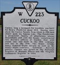
|   Cuckoo Cuckoo
in Virginia Historical Markers Located along route 522 this marker stands next to another. posted by:  flyingmoose flyingmoose location: Virginia date approved: 10/30/2006 last visited: 09/12/2012 |
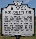 view gallery view galleryNW0.2 km | Jack Jouett's Ride in Virginia Historical Markers Located along route 522 this marker stands next to another. posted by: flyingmoose location: Virginia date approved: 10/30/2006 last visited: 10/04/2010 |
 view gallery view gallery N6.6 km N6.6 km
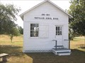
|  Trevilians School 1880-1922 - Mineral, VA Trevilians School 1880-1922 - Mineral, VA
in Former Schools A small schoolhouse from the end of the 19th century. posted by: Taluss location: Virginia date approved: 09/12/2008 last visited: never |
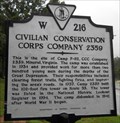 view gallery view galleryNW8.7 km | Civilian Conservation Corps Company 2359 in Virginia Historical Markers CCC group from Mineral, VA did typical forestry tasks, including building a fire tower along SR33. posted by: vhasler location: Virginia date approved: 09/09/2011 last visited: never |
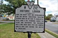 view gallery view galleryNW11.6 km | Historic Louisa in Virginia Historical Markers This Historic Marker is located on Main Street in the Town of Louisa. posted by: Sneakin Deacon location: Virginia date approved: 11/21/2010 last visited: never |
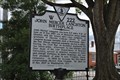 view gallery view galleryNW12.1 km | John Mercer Langston in Virginia Historical Markers This historic marker stands on the grounds of the Louisa County Courthouse in Louisa, Virginia. posted by: Sneakin Deacon location: Virginia date approved: 10/17/2010 last visited: 08/18/2012 |
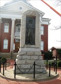 view gallery view galleryNW12.1 km |  Confederate Monument - Louisa, VA Confederate Monument - Louisa, VA
in Smithsonian Art Inventory Sculptures Confederate soldier as a bronze relief sculpture set in a granite block. Located on the courthouse grounds. posted by: vhasler location: Virginia date approved: 12/17/2011 last visited: 10/02/2012 |
 view gallery view galleryNW12.1 km |  Louisa County Courthouse - Louisa, Virginia Louisa County Courthouse - Louisa, Virginia
in Courthouses The Louisa County Courthouse is located in the historic town of Louisa, Virginia posted by: Sneakin Deacon location: Virginia date approved: 11/15/2010 last visited: 10/02/2012 |
 view gallery view galleryNW12.1 km |  Louisa County Courthouse - Louisa, Virginia Louisa County Courthouse - Louisa, Virginia
in U.S. National Register of Historic Places The Louisa County Courthouse stands on the courthouse square at the center of Louisa, Virginia posted by: Sneakin Deacon location: Virginia date approved: 11/11/2010 last visited: 08/24/2012 |
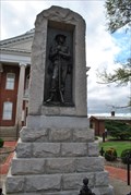 view gallery view galleryNW12.1 km |  Louisa County Confederate Memorial - Louisa Virginia Louisa County Confederate Memorial - Louisa Virginia
in American Civil War Monuments and Memorials The Louisa County Confederate Memorial stands on the grounds of the Louisa County Courthouse. posted by: Sneakin Deacon location: Virginia date approved: 11/15/2010 last visited: 08/18/2012 |
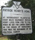 view gallery view galleryNW12.1 km | Patrick Henry's Home in Virginia Historical Markers Patrick Henry was from Louisa County posted by: vhasler location: Virginia date approved: 07/24/2011 last visited: 10/26/2011 |
 view gallery view gallery NE18 km NE18 km
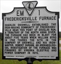
| Fredericksville Furnace in Virginia Historical Markers An 1800s iron furance was near here. posted by: vhasler location: Virginia date approved: 09/09/2011 last visited: never |
 view gallery view gallery W18.7 km W18.7 km
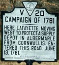
| Campaign of 1781 in Virginia Historical Markers Plaque in front of large rural church posted by:  johnjm99 johnjm99 location: Virginia date approved: 02/25/2006 last visited: 07/03/2012 |
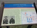 view gallery view galleryNW18.8 km | Custer Rescued-An All-out Assault - Louisa VA in U.S. Civil War Sites By mid-morning on June 11, 1864, Gen. George A. Custer's attack on Confederate Gen. Wade Hampton's wagon train here had gone from success to near disaster as Southern cavalry surrounded Custer's force. posted by: Don.Morfe location: Virginia date approved: 06/29/2023 last visited: 06/29/2023 |
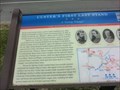 view gallery view galleryNW18.8 km | Custer's First Last Stand-A "Living Triangle" - Louisa VA in U.S. Civil War Sites About 8 a.m., Union Gen. George A. Custer's Michigan Brigade turned west onto the Gordonsville Road from the Nunn's Creek Road at Mildred Crossing, with Col. Russell A. Alger's 5th Michigan Cavalry leading the way. posted by: Don.Morfe location: Virginia date approved: 06/29/2023 last visited: 06/29/2023 |
 view gallery view galleryNW18.8 km | Custer's First Last Stand A "Living Triangle" - Louisa VA in Civil War Discovery Trail Sites Nearby stood Trevilian Station, south of which Confederate Gen. Wade Hampton had parked his wagon train on the evening of June 10, 1864. posted by: Don.Morfe location: Virginia date approved: 07/24/2020 last visited: 10/05/2021 |
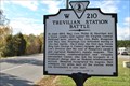 view gallery view galleryNW18.8 km | Trevilian Station Battle in Virginia Historical Markers This historic marker stands on Route 33 near the community of Trevilian in Louisa County, Virginia posted by: Sneakin Deacon location: Virginia date approved: 11/21/2010 last visited: 10/02/2012 |
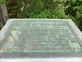 view gallery view galleryNW19 km |  Battle of Trevillians - Louisa VA Battle of Trevillians - Louisa VA
in Battlefields Fought here June 11, 12, 1864 —
Confederate Gens. Wade Hampton, Fitzhugh Lee
and Thomas L. Rosser, victors over
Federal Gens. P.H. Sheridan and G.A. Custer posted by: Don.Morfe location: Virginia date approved: 11/21/2020 last visited: 10/16/2021 |
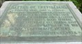 view gallery view galleryNW19 km | Battle of Trevillians - Louisa VA in U.S. Civil War Sites — Fought here June 11, 12, 1864 —Greatest all-cavalry battle of the war. Signal Confederate victory posted by: Don.Morfe location: Virginia date approved: 07/28/2020 last visited: 10/04/2021 |
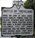 view gallery view galleryNW19 km | Battle of Trevilians in Virginia Historical Markers US Civil War battle posted by: vhasler location: Virginia date approved: 09/09/2011 last visited: 10/02/2012 |
 view gallery view gallery S19.2 km S19.2 km
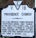
| Providence Church in Virginia Historical Markers 18th century Presbyterian Church posted by: johnjm99 location: Virginia date approved: 02/25/2006 last visited: 08/17/2008 |
 view gallery view galleryS19.6 km |  Gum Spring, VA 23065 ~ Main Post Office Gum Spring, VA 23065 ~ Main Post Office
in U.S. Post Offices A post office just south of Interstate 64. posted by: bluesnote location: Virginia date approved: 12/26/2014 last visited: 12/26/2014 |
 view gallery view galleryS19.6 km |  Gum Spring, Virginia Gum Spring, Virginia
in Wikipedia Entries A small town in real Louisa County, Virginia. posted by: bluesnote location: Virginia date approved: 03/26/2021 last visited: 03/26/2021 |
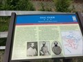 view gallery view galleryNW21.2 km | Ogg Farm-Repulsed with Heavy Losses - Louisa VA in U.S. Civil War Sites he apex of that line became known as the Bloody Angle during the heavy fighting later that day. Col. Richard. H. Dulany’s and Col. Gilbert J. Wright’s brigades supported the South Carolinians and extended the line past the Ogg House. posted by: Don.Morfe location: Virginia date approved: 06/29/2023 last visited: 06/29/2023 |
 view gallery view gallery E21.6 km E21.6 km
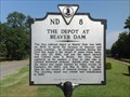
| The Depot at Beaver Dam in Virginia Historical Markers This small train station in Beaver Dam played a significant part in the Civil War. posted by: teeoff2 location: Virginia date approved: 07/17/2012 last visited: 12/31/2014 |
|