 view gallery view gallery S8.9 km S8.9 km
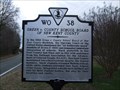
|   Green v. County School Board of New Kent County Green v. County School Board of New Kent County
in Virginia Historical Markers This marker describes the outcome of a Supreme Court decision. posted by:  archway archway location: Virginia date approved: 02/06/2010 last visited: never |
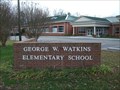 view gallery view galleryS9 km |  New Kent School; Watkins, George W., School - Quinton, VA New Kent School; Watkins, George W., School - Quinton, VA
in U.S. National Register of Historic Places This school in New Kent County was the subject of a Supreme Court decision in 1968. posted by: archway location: Virginia date approved: 12/19/2009 last visited: never |
 view gallery view gallery SE9.8 km SE9.8 km
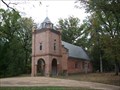
|  St. Peter's Church - New Kent, VA St. Peter's Church - New Kent, VA
in This Old Church St. Peter's Church was built in 1703 and is believed to be the site where Col. George Washington married Martha Dandridge Custis in 1759. posted by: archway location: Virginia date approved: 11/22/2009 last visited: never |
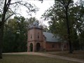 view gallery view gallerySE9.8 km | St. Peter's Church - New Kent, VA in U.S. National Register of Historic Places St. Peter's Church was built in 1703 and was almost destroyed during the Civil War. Martha Washington, the first First Lady and a New Kent native, married George Washington here in 1759. posted by: archway location: Virginia date approved: 11/23/2009 last visited: never |
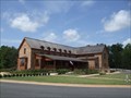 view gallery view gallerySE9.8 km |  New Kent Winery New Kent Winery
in Wineries This winery is located in historic New Kent County, halfway between Richmond and Williamsburg. The first vines were planted in 2001, and the winery itself opened in 2008. posted by: archway location: Virginia date approved: 08/30/2009 last visited: 11/26/2011 |
 view gallery view gallery NW9.8 km NW9.8 km
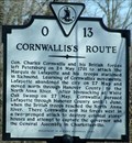
| Cornwallis's Route in Virginia Historical Markers Two markers side by side - this is Cornwallis's Route. posted by:  johnjm99 johnjm99 location: Virginia date approved: 02/26/2006 last visited: 07/31/2006 |
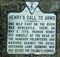 view gallery view galleryNW9.8 km | Henry's Call to Arms in Virginia Historical Markers Two side by side, this is Henry's Call to Arms posted by: johnjm99 location: Virginia date approved: 02/26/2006 last visited: never |
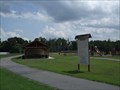 view gallery view galleryS9.8 km |  Quinton Community Park - New Kent Co., VA Quinton Community Park - New Kent Co., VA
in Municipal Parks and Plazas A New Kent County park located in Quinton. The park is easily accessible from I-64, exit 205. posted by: archway location: Virginia date approved: 08/09/2009 last visited: never |
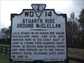 view gallery view gallerySE10.1 km | Stuart's Ride Around McClellan in Virginia Historical Markers J.E.B. Stuart's reconnaissance mission in 1862 was a media sensation for the Confederacy. posted by: archway location: Virginia date approved: 02/06/2010 last visited: 07/06/2013 |
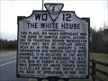 view gallery view gallerySE10.1 km | The White House in Virginia Historical Markers The White House was the family home of Martha Washington. posted by: archway location: Virginia date approved: 02/06/2010 last visited: 07/06/2013 |
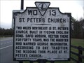 view gallery view gallerySE10.1 km | St. Peter's Church in Virginia Historical Markers St. Peter's Church, located about two miles away from this historical marker, is believed to be the location where George Washington married Martha Custis Dandridge. posted by: archway location: Virginia date approved: 02/06/2010 last visited: 07/06/2013 |
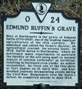 view gallery view galleryNW10.1 km | Edmund Ruffin's Grave in Virginia Historical Markers Grave of Edmund Ruffin posted by: johnjm99 location: Virginia date approved: 02/26/2006 last visited: never |
 view gallery view gallery SW10.8 km SW10.8 km
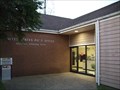
|  Quinton, VA 23141 Quinton, VA 23141
in U.S. Post Offices This small post office is tucked behind some retail shops. posted by: archway location: Virginia date approved: 11/27/2009 last visited: never |
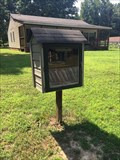 view gallery view gallerySW10.9 km |  Little Free Library #11989 - Quinton, VA Little Free Library #11989 - Quinton, VA
in Free Community Book Exchanges Little Free Library in Quinton posted by: stinger503 location: Virginia date approved: 07/19/2017 last visited: never |
 view gallery view gallery N11.9 km N11.9 km
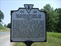
| Headquarters of Opechancanough in Virginia Historical Markers Marker describing the Chief of the Pamunkey Tribe. posted by: archway location: Virginia date approved: 06/13/2010 last visited: 02/08/2014 |
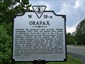 view gallery view gallerySW12.1 km | Orapax in Virginia Historical Markers Marker commemorating the location of an extinct Native American town. posted by: archway location: Virginia date approved: 06/13/2010 last visited: never |
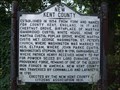 view gallery view gallerySW12.2 km | New Kent County in Virginia Historical Markers Placed in 1931, this marker briefly describes the history of New Kent County. It is located near the Chickahominy River and Bottom's Bridge on US 60. Six historical markers are located here. posted by: archway location: Virginia date approved: 09/02/2009 last visited: 04/14/2004 |
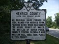 view gallery view gallerySW12.2 km | Henrico County / New Kent County in Virginia Historical Markers A two-sided historical marker at the border of Henrico County and New Kent County near the Chickahominy River and Bottom's Bridge on US 60. Five other historical markers are located here. posted by: archway location: Virginia date approved: 09/02/2009 last visited: 04/14/2004 |
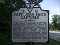 view gallery view gallerySW12.2 km | Capt. John Smith Captured in Virginia Historical Markers This historical marker is located near the Chickahominy River and Bottom's Bridge on US 60. Six historical markers are located here. posted by: archway location: Virginia date approved: 09/02/2009 last visited: 04/14/2004 |
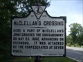 view gallery view gallerySW12.2 km | McClellan's Crossing in Virginia Historical Markers This historical marker is located near the Chickahominy River and Bottom's Bridge on US 60. Six historical markers are located here.
posted by: archway location: Virginia date approved: 09/02/2009 last visited: 06/03/2001 |
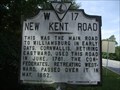 view gallery view gallerySW12.2 km | New Kent Road in Virginia Historical Markers This historical marker is located near the Chickahominy River and Bottom's Bridge on US 60. Six historical markers are located here. posted by: archway location: Virginia date approved: 09/07/2009 last visited: 06/03/2001 |
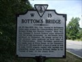 view gallery view gallerySW12.2 km | Bottom's Bridge in Virginia Historical Markers A historical marker is located on US 60 near the intersection with White Oak Road. Five other historical markers are located here. This one is located in Henrico County, the other five are in New Kent County. posted by: archway location: Virginia date approved: 09/07/2009 last visited: 06/03/2001 |
 view gallery view galleryS12.6 km |  Clista's Coffee & Cream Clista's Coffee & Cream
in Independent Coffee Shops Located on US-60 east of Richmond, VA with easy access from I-64. posted by: archway location: Virginia date approved: 08/02/2009 last visited: never |
 view gallery view gallery W12.6 km W12.6 km
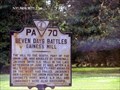
|  Seven Days Battles Gaines's Mill - Mechanicsville VA Seven Days Battles Gaines's Mill - Mechanicsville VA
in Battlefields Marker is on Cold Harbor Road (State Highway 156), Mechanicsville VA 23111 posted by: Don.Morfe location: Virginia date approved: 07/09/2023 last visited: 07/09/2023 |
 view gallery view galleryW12.6 km |  Seven Days Battles Gaines's Mill - Mechanicsville VA Seven Days Battles Gaines's Mill - Mechanicsville VA
in American Civil War Monuments and Memorials Marker is on Cold Harbor Road (State Highway 156), Mechanicsville VA 23111 posted by: Don.Morfe location: Virginia date approved: 07/17/2023 last visited: 07/17/2023 |
|