 view gallery view gallery SE0.2 km SE0.2 km
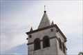
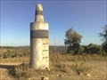
|   Barranco Barranco
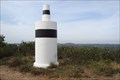
in Portugal Geodetic Points Church Tower posted by:  Vedot67 Vedot67 location: Faro, Portugal date approved: 06/04/2012 last visited: never |
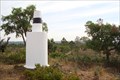 view gallery view gallery NW2.4 km NW2.4 km
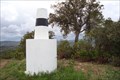
| Eira Alta in Portugal Geodetic Points Mark in one of Algarve's nicest peaks. posted by: Vedot67 location: Faro, Portugal date approved: 06/04/2012 last visited: never |
 view gallery view gallery N2.7 km N2.7 km
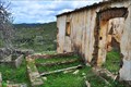
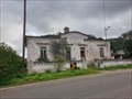
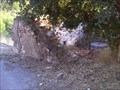
|  Pêro d'Elvas, Portugal Pêro d'Elvas, Portugal
in Ghost Towns The ghost village of Pero D’Elvas is located at a top of a small hill within the mountains of Serra do Caldeirão and close to Odeleite stream. posted by:  Torgut Torgut location: Faro, Portugal date approved: 09/26/2011 last visited: never |
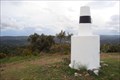 view gallery view gallery SW3.7 km SW3.7 km
| Cepo in Portugal Geodetic Points On the top of the hill. posted by: Vedot67 location: Faro, Portugal date approved: 04/28/2012 last visited: never |
 view gallery view gallery W4.3 km W4.3 km
| Esguicho de Água in Portugal Geodetic Points The one out in the wild posted by: Vedot67 location: Faro, Portugal date approved: 04/28/2012 last visited: never |
 view gallery view gallery S5.1 km S5.1 km
| Bispo in Portugal Geodetic Points Nice view from the top of the mountain. posted by: Vedot67 location: Faro, Portugal date approved: 05/19/2012 last visited: never |
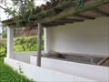 view gallery view gallerySW5.3 km | ") Lavadouro da Adega - Querença, Portugal Lavadouro da Adega - Querença, Portugal
in Lavoir (wash houses) This wash house is located in the hamlet of Adega, in the vicinity of the village of Querença, in southern Portugal posted by: Torgut location: Faro, Portugal date approved: 01/31/2021 last visited: never |
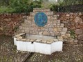
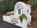 view gallery view gallerySW5.3 km |  Fonte da Adega - Querença, Portugal Fonte da Adega - Querença, Portugal
in Spring Houses This is a spring house located in the hamlet of Adega, not far from a village named Querença, in Southern Portugal posted by: Torgut location: Faro, Portugal date approved: 02/12/2021 last visited: never |
 view gallery view gallerySW5.6 km |  Casa de Cantoneiros - Querença, Portugal Casa de Cantoneiros - Querença, Portugal
in Unoccupied Buildings, Shacks, and Cabins This abandoned house was once part of "Cantoneiros" network. These were the fellows in charge for keeping the roads of the country in good condition. posted by: Torgut location: Faro, Portugal date approved: 02/12/2021 last visited: never |
 view gallery view gallerySW5.6 km |  PR 13 LLE Serras e Montes - Querença, Portugal PR 13 LLE Serras e Montes - Querença, Portugal
in Hiking and walking trailheads This is one of the few possible starts for a walking trail named PR13 LLE Montes e Campos, in southern Portugal posted by: Torgut location: Faro, Portugal date approved: 02/12/2021 last visited: never |
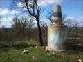
 view gallery view gallerySW5.8 km | Negro in Portugal Geodetic Points Cerro dos Negros, Querença, north of Loulé, 392m elevation posted by: Vedot67 location: Faro, Portugal date approved: 01/28/2012 last visited: never |
 view gallery view gallerySW6.1 km |  Manuel Gomes Guerreiro - Querença, Portugal Manuel Gomes Guerreiro - Querença, Portugal
in Citizen Memorials A plaque dedicated to one of the most notorious Algarvians of the 20th Century: Manuel Gomes Guerreiro posted by: Torgut location: Faro, Portugal date approved: 01/24/2021 last visited: never |
 view gallery view gallery NE6.1 km NE6.1 km
| Fonte da Cruz in Portugal Geodetic Points A mark by a paved road. posted by: Vedot67 location: Faro, Portugal date approved: 07/11/2012 last visited: never |
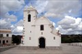 view gallery view gallerySW6.3 km |  Church of Nossa Senhora da Assunção - Querença Church of Nossa Senhora da Assunção - Querença
in This Old Church Beutiful old church in tiny town. posted by: Vedot67 location: Faro, Portugal date approved: 04/28/2012 last visited: 08/29/2012 |
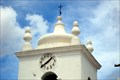 view gallery view gallerySW6.3 km | Querença in Portugal Geodetic Points Catavento - top of the church tower. posted by: Vedot67 location: Faro, Portugal date approved: 04/28/2012 last visited: never |
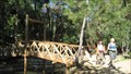 view gallery view galleryS6.8 km |  Fonte Férrea, S. Bras de Alportel, Portugal Fonte Férrea, S. Bras de Alportel, Portugal
in Hiking Path Footbridges Hiking Path Footbridge located in the municipal park of Fonte Férrea, in the Algarve, Portugal. posted by: SUp3rFM & Cruella location: Portugal date approved: 10/18/2007 last visited: never |
 view gallery view gallery E6.9 km E6.9 km
| Quatrelas in Portugal Geodetic Points At Serra de Caldeirão posted by: Vedot67 location: Faro, Portugal date approved: 03/10/2013 last visited: never |
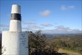
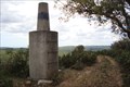 view gallery view galleryS6.9 km | Atalaia das Figueiras in Portugal Geodetic Points Peak of the mountain, nice view posted by: Vedot67 location: Faro, Portugal date approved: 05/19/2012 last visited: never |
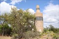
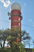 view gallery view galleryN7.1 km |  Serra do Caldeirão - Barranco do Velho, Portugal Serra do Caldeirão - Barranco do Velho, Portugal
in Weather Radars Weather Radar of Serra do Caldeirão is one of the two working weather radars, in Portugal's mainland, and is operated by the Portuguese Meteorological Institute posted by: Torgut location: Faro, Portugal date approved: 01/31/2013 last visited: never |
 view gallery view gallerySW7.1 km |  Fonte Benémola - Querença Fonte Benémola - Querença
in State/Provincial Parks Picnic, walking and resting park. posted by: Vedot67 location: Faro, Portugal date approved: 02/08/2012 last visited: 02/08/2012 |
 view gallery view gallerySW7.2 km |  Lost millstone - Querença, Portugal Lost millstone - Querença, Portugal
in Millstones In a house in ruins, a couple of abandoned millstones posted by: Torgut location: Faro, Portugal date approved: 10/20/2014 last visited: never |
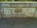 view gallery view gallerySW7.2 km |  Ponte da Esparrela - 1934 - Querença, Portugal Ponte da Esparrela - 1934 - Querença, Portugal
in Bridge Date Stones and Plaques Located in the Caldeirão mountains, in Southern Portugal, this bridge is part of a dirt road and it crosses a minor stream. posted by: Torgut location: Faro, Portugal date approved: 10/16/2014 last visited: never |
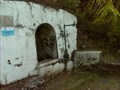 view gallery view gallerySW7.2 km | Fonte da Esparrela - Querença, Portugal in Spring Houses This is a spring house lost in the mountains of Caldeirão, in Southern Portugal. posted by: Torgut location: Faro, Portugal date approved: 10/16/2014 last visited: never |
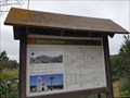
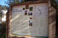
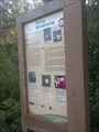 view gallery view gallerySW7.4 km |  Flora of Fonte Benémola - Querença, Portugal Flora of Fonte Benémola - Querença, Portugal
in Flora and Fauna Information Signs This sign explains the existent flora in Fonte Benemola, Algarve, Portugal. posted by: Torgut location: Faro, Portugal date approved: 12/29/2017 last visited: 01/02/2018 |
 view gallery view galleryN7.6 km | Pelados in Portugal Geodetic Points Mark in the nature posted by: Vedot67 location: Faro, Portugal date approved: 06/04/2012 last visited: never |
|