 view gallery view gallery N3.7 km N3.7 km
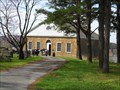
|   Thebes Courthouse - Thebes, Illinois Thebes Courthouse - Thebes, Illinois
in Wikipedia Entries Historic former county courthouse high on the bluff overlooking the Mississippi River in Thebes, Illinois. posted by:  iconions iconions location: Illinois date approved: 08/05/2017 last visited: 06/05/2017 |
 view gallery view galleryN3.7 km |  Thebes Courthouse -Thebes, Illinois Thebes Courthouse -Thebes, Illinois
in U.S. National Register of Historic Places Historic former county courthouse high on the bluff overlooking the Mississippi River in Thebes, Illinois. posted by:  BruceS BruceS location: Illinois date approved: 05/05/2009 last visited: 04/02/2017 |
 view gallery view galleryN3.7 km |  Thebes Courthouse -Thebes, Illinois Thebes Courthouse -Thebes, Illinois
in Courthouses Historic former county courthouse high on the bluff overlooking the Mississippi River in Thebes, Illinois. posted by: BruceS location: Illinois date approved: 05/08/2009 last visited: 04/02/2017 |
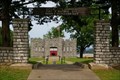
 view gallery view galleryN3.7 km |  Old Alexander County Courthouse - Thebes, Illinois Old Alexander County Courthouse - Thebes, Illinois
in American Guide Series Historic former county courthouse high on the bluff overlooking the Mississippi River in Thebes, Illinois. posted by: BruceS location: Illinois date approved: 05/07/2009 last visited: 04/02/2017 |
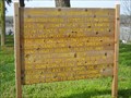 view gallery view galleryN3.7 km |  Thebes Courthouse - Thebes, Illinois Thebes Courthouse - Thebes, Illinois
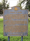
in Illinois Historical Markers This is a wooden sign placed by the Town of Thebes describing the very historical Thebes (former Alexander County)Courthouse. It is located at Oak and 5th Streets in Thebes. posted by: iconions location: Illinois date approved: 03/21/2012 last visited: never |
 view gallery view galleryN4.3 km | Steamboats on the Mississippi River in Illinois Historical Markers This marker is placed at a roadside rest area and scenic overlook off of Route 3 in Thebes, IL. posted by:  NoLemon NoLemon location: Illinois date approved: 09/05/2006 last visited: 08/05/2011 |
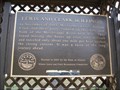 view gallery view galleryN4.3 km | Lewis and Clark in Illinois - Thebes, Illinois in Illinois Historical Markers Historical marker located at wayside along the Mississippi River just north of Thebes. posted by: BruceS location: Illinois date approved: 05/05/2009 last visited: 06/05/2006 |
 view gallery view galleryN4.3 km |  Lewis and Clark in Illinois - Thebes, Illinois Lewis and Clark in Illinois - Thebes, Illinois
in Lewis and Clark Trail Historical marker located at wayside along the Mississippi River just north of Thebes. posted by: BruceS location: Illinois date approved: 05/06/2009 last visited: 06/05/2006 |
 view gallery view gallery NW7.2 km NW7.2 km
|  Municipal Flag - Scott City, Mo. Municipal Flag - Scott City, Mo.
in Municipal Flags This municipal flag is located at the Scott City City Hall located at 215 Chester Avenue. posted by: iconions location: Missouri date approved: 03/27/2012 last visited: never |
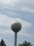 view gallery view galleryN12.2 km |  East Cape Girardeau - Water Tower - East Cape Girardeau, Illinois East Cape Girardeau - Water Tower - East Cape Girardeau, Illinois
in Water Towers Older "Globe" type of water tower in the town of East Cape Girardeau posted by: Mesozoic location: Illinois date approved: 06/18/2016 last visited: never |
 view gallery view gallery SW13 km SW13 km
|  McDonald's - MO-77 - Benton, MO McDonald's - MO-77 - Benton, MO
in McDonald's Restaurants Recently remodeled..to modern facade...check out Google and see the OLD 50's look of the site. posted by: YoSam. location: Missouri date approved: 12/23/2018 last visited: never |
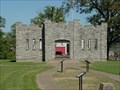 view gallery view galleryNW13 km |  Fort D Civil War Fort Fort D Civil War Fort
in Historic Forts Constructed in the summer of 1861 by Union troops under the leadership of John Wesley Powell, Fort D is the only one of the four original Cape Girardeau forts remaining. posted by: paulspaper location: Missouri date approved: 10/16/2007 last visited: 03/21/2015 |
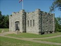 view gallery view galleryNW13 km |  Fort D Civil War Fort Fort D Civil War Fort
in U.S. Civil War Sites Constructed in the summer of 1861 by Union troops under the leadership of John Wesley Powell, Fort D is the only one of the four original Cape Girardeau forts remaining. posted by: paulspaper location: Missouri date approved: 10/15/2007 last visited: 03/21/2015 |
 view gallery view galleryNW13 km |  Fort D, Cape Girardeau, Missouri Fort D, Cape Girardeau, Missouri
in WPA Projects Fort D, Cape Girardeau, Missouri posted by: kJfishman location: Missouri date approved: 06/15/2008 last visited: 03/21/2015 |
 view gallery view galleryN13 km |  MO / IL - MO 74 to IL 146 - MO / IL - MO 74 to IL 146 -
in Border Crossings Driving from West to East leaving Cape Giradeau into McClure, IL on Shawnee Parkway. posted by: nomadwillie location: Illinois date approved: 01/16/2017 last visited: never |
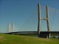 view gallery view galleryNW13.2 km |  Bill Emerson Memorial Bridge - Cape Girardeau, Missouri Bill Emerson Memorial Bridge - Cape Girardeau, Missouri
in Suspension Bridges The Bill Emerson Memorial Bridge is a cable-stayed bridge connecting Missouri's Route 34 and Route 74 with Illinois Route 146 across the Mississippi River between Cape Girardeau, Missouri and East Cape Girardeau, Illinois. posted by: paulspaper location: Missouri date approved: 10/15/2007 last visited: 10/12/2020 |
 view gallery view galleryN13.4 km | Welcome to Illinois in Illinois Historical Markers This Illinois Historical Marker is located at a roadside rest area near the bridge to Illinois from Cape Giradeau, MO. posted by: NoLemon location: Illinois date approved: 09/05/2006 last visited: 09/17/2011 |
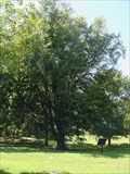 view gallery view galleryNW13.4 km |  American Beech American Beech
in Exceptional Trees This Missouri Champion American Beech is one of the oldest and largest trees in Missouri. posted by: paulspaper location: Missouri date approved: 10/16/2007 last visited: 06/16/2016 |
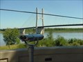 view gallery view galleryNW13.4 km |  Free BINO - Mississippi River, Cape Girardeau, Missouri Free BINO - Mississippi River, Cape Girardeau, Missouri
in Coin-Op Binoculars Free binoculars on an new overlook. It is overlooking the Mississippi River and the new bridge at Cape Girardeau. posted by: paulspaper location: Missouri date approved: 10/20/2007 last visited: 06/16/2016 |
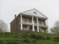
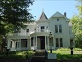 view gallery view galleryNW13.5 km | Glenn House - Cape Girardeau, MO in U.S. National Register of Historic Places This victorian house, built in 1883, exquisitely depicts life of that era. posted by: paulspaper location: Missouri date approved: 10/13/2007 last visited: 03/21/2015 |
 view gallery view gallerySW13.5 km | Benton, Missouri in Wikipedia Entries One of the first counties to be formed, and Benton is the county seat... posted by: YoSam. location: Missouri date approved: 12/12/2019 last visited: 11/20/2020 |
 view gallery view gallerySW13.5 km |  Benton, Missouri Benton, Missouri
in People-Named Places County seat of second county formed in the new state of Missouri posted by: YoSam. location: Missouri date approved: 12/12/2019 last visited: 11/20/2020 |
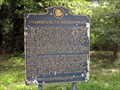
 view gallery view gallerySW13.5 km |  El Camino Real - Benton, Missouri El Camino Real - Benton, Missouri
in Wagon Roads and Trails Marker for old French/Spanish trail running from New Madrid to St. Louis, located on the grounds of the Scott County Courthouse in Benton, Missouri. posted by: BruceS location: Missouri date approved: 10/30/2009 last visited: 08/07/2011 |
 view gallery view gallerySW13.5 km |  El Camino Real - Benton, Missouri El Camino Real - Benton, Missouri
in Missouri Historical Markers Marker for old French/Spanish trail running from New Madrid to St. Louis, located on the grounds of the Scott County Courthouse in Benton, Missouri. posted by: BruceS location: Missouri date approved: 10/29/2009 last visited: 09/05/2011 |
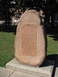 view gallery view gallerySW13.5 km |  El Camino Real - Benton, Missouri El Camino Real - Benton, Missouri
in Ancient Traces and Roads Marker for old French/Spanish trail following old Native American trails from New Madrid to St. Louis, located on the grounds of the Scott County Courthouse in Benton, Missouri. posted by: BruceS location: Missouri date approved: 10/30/2009 last visited: 08/07/2011 |
|