 view gallery view gallery SW1.9 km SW1.9 km
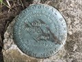
|   58 B - Sumner County, Kansas 58 B - Sumner County, Kansas
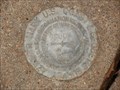
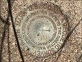
in U.S. Benchmarks A "decapitated" USGS benchmark near the intersection of Woodlawn Road and 150th Street, to the southwest of Ashton. posted by:  Tom.dog Tom.dog location: Kansas date approved: 07/31/2023 last visited: never |
 view gallery view gallery N4.7 km N4.7 km
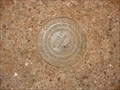
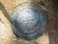
| ASHTON Azimuth Mark - Sumner County, Kansas in U.S. Benchmarks A azimuth mark for triangulation station ASHTON on the west side of S Rock Road. posted by: Tom.dog location: Kansas date approved: 11/04/2022 last visited: never |
 view gallery view galleryN4.7 km |  ASHTON Azimuth Mark - Sumner County, Kansas ASHTON Azimuth Mark - Sumner County, Kansas
in Azimuth Benchmarks Azimuth Mark for NGS BM ASHTON, established in 1957. posted by: Tom.dog location: Kansas date approved: 11/25/2012 last visited: never |
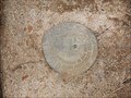 view gallery view galleryN5.3 km | ASHTON (HF1330) - Sumner County, Kansas in U.S. Benchmarks Triangulation Station ASHTON located North of the town of Ashton in Sumner County, KS. posted by: Tom.dog location: Kansas date approved: 11/29/2012 last visited: never |
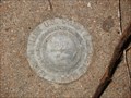
 view gallery view galleryN5.5 km | 53 B - Sumner County, Kansas in U.S. Benchmarks USGS Bench Mark located Northwest of Geuda Springs, KS. posted by: Tom.dog location: Kansas date approved: 11/25/2012 last visited: 07/30/2023 |
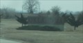
 view gallery view gallery E6.9 km E6.9 km
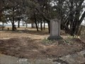
|  Lollik Cemetery - Sumner County, KS Lollik Cemetery - Sumner County, KS
in Worldwide Cemeteries A one-acre cemetery established on an old homestead, in Sumner County, Kansas, is the final rest for about twenty souls. posted by: The Snowdog location: Kansas date approved: 07/15/2020 last visited: never |
 view gallery view galleryE8.4 km |  Two Rivers Geuda Springs Elevator Two Rivers Geuda Springs Elevator
in Grain Elevators This Grain Elevator is located at 1380 E 160th Street South in Geuda Springs, Kansas. posted by: brwhiz location: Kansas date approved: 02/08/2013 last visited: never |
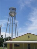
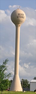 view gallery view galleryE8.4 km |  Geuda Springs Water Tower Geuda Springs Water Tower
in Water Towers This water tower is located on the east side of 2nd Street just north of Summit Street/County Road 10 in Geuda Springs, Kansas. posted by: brwhiz location: Kansas date approved: 02/22/2013 last visited: never |
 view gallery view gallery NE8.7 km NE8.7 km
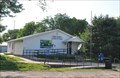
|  Geuda Springs, Kansas 67051 Geuda Springs, Kansas 67051
in U.S. Post Offices This Post Office is located at 117 S 1st Street in Geuda Springs, Kansas. posted by: brwhiz location: Kansas date approved: 09/02/2012 last visited: never |
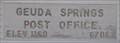 view gallery view galleryNE8.7 km |  Geuda Springs, Kansas ~ Elevation 1160 Feet Geuda Springs, Kansas ~ Elevation 1160 Feet
in Elevation Signs This Elevation Sign is part of the name board on the US Post Office in Geuda Springs, Kansas. posted by: brwhiz location: Kansas date approved: 09/07/2012 last visited: never |
 view gallery view galleryE8.9 km | GEUDA Azimuth Mark - Cowley County, Kansas in Azimuth Benchmarks GEUDA Azimuth Mark, located on the East side of the town of Geuda Springs in Cowley County, KS. posted by: Tom.dog location: Kansas date approved: 11/25/2012 last visited: never |
 view gallery view galleryE8.9 km | GEUDA Azimuth Mark - Cowley County, Kansas in U.S. Benchmarks Azimuth mark for the GEUDA triangulation station. posted by: Tom.dog location: Kansas date approved: 10/30/2022 last visited: never |
 view gallery view gallery S9.3 km S9.3 km
| BITTER RESET NO 3 - Kay County, Oklahoma in U.S. Benchmarks Reference mark 3 for triangulation station BITTER RESET. posted by: Tom.dog location: Oklahoma date approved: 11/17/2022 last visited: never |
 view gallery view galleryS9.3 km | BITTER RESET NO 4 - Kay County, Oklahoma in U.S. Benchmarks Reference mark 4 for triangulation station BITTER RESET. posted by: Tom.dog location: Oklahoma date approved: 11/17/2022 last visited: never |
 view gallery view galleryNE11.4 km | U.S. Engineer Department S C. 9 - Adamsville, KS in U.S. Benchmarks This U.S. Engineer Department station disk is at the intersection of two country roads - southeast of Adamsville, Kansas. posted by: The Snowdog location: Kansas date approved: 05/12/2023 last visited: 07/17/2023 |
 view gallery view gallerySW13 km |  KS-OK on I-35 -- nr Brahman OK KS-OK on I-35 -- nr Brahman OK
in Border Crossings The busy border crossing over a historic latitude line between Kansas and Oklahoma on I-35, heading southbound. posted by: Benchmark Blasterz location: Kansas date approved: 05/08/2013 last visited: 03/16/2013 |
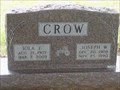 view gallery view gallery W13.4 km W13.4 km
|  101 - Iola E. Crow - Rose Hill Cemetery - South Haven, KS 101 - Iola E. Crow - Rose Hill Cemetery - South Haven, KS
in Headstones of Centenarians Centenarian Iola Crow is laid to rest on the east side of Rose Hill Cemetery. posted by: Max and 99 location: Kansas date approved: 07/23/2020 last visited: never |
 view gallery view galleryW13.4 km | 100 - Roy Melvin Cottle - Rose Hill Cemetery - South Haven, KS in Headstones of Centenarians Centenarian Roy Cottle is laid to rest at the north side of Rose Hill Cemetery. posted by: Max and 99 location: Kansas date approved: 07/19/2020 last visited: never |
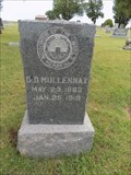 view gallery view galleryW13.5 km |  D D Mullennax - Rose Hill Cemetery - South Haven, KS D D Mullennax - Rose Hill Cemetery - South Haven, KS
in Woodmen of the World Grave Markers/Monuments A modern Woodmen of the World marker for David Dallas Mullennax is located in Rose Hill Cemetery. posted by: Max and 99 location: Kansas date approved: 07/19/2020 last visited: never |
 view gallery view galleryW13.5 km |  C.A. Murray - Rose Hill Cemetery - South Haven, KS C.A. Murray - Rose Hill Cemetery - South Haven, KS
in Homemade Tombstones A homemade tombstone for C.A. Murray is at the northwest side of Rose Hill Cemetery. posted by: Max and 99 location: Kansas date approved: 07/24/2020 last visited: never |
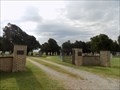 view gallery view galleryW13.5 km | Rose Hill Cemetery - South Haven, KS - USA in Worldwide Cemeteries This rural cemetery in south Kansas is well maintained. posted by: Max and 99 location: Kansas date approved: 07/15/2020 last visited: never |
 view gallery view galleryNE13.8 km | RAINBOW Azimuth Mark - Cowley County, Kansas in Azimuth Benchmarks The roadside azimuth mark for triangulation station RAINBOW (HF1329), north of the historic community of Rainbow Bend. posted by: Tom.dog location: Kansas date approved: 07/31/2023 last visited: never |
 view gallery view galleryNE13.8 km | RAINBOW Azimuth Mark - Cowley County, Kansas in U.S. Benchmarks This is the azimuth mark for triangulation station RAINBOW (HF1329). posted by: Tom.dog location: Kansas date approved: 07/31/2023 last visited: never |
 view gallery view galleryW15 km | South Haven Water Tower, South Haven, Kansas in Water Towers South Haven Water Tower located in South Haven, considered a tea pot tower. posted by:  okgranny49 okgranny49 location: Kansas date approved: 06/24/2010 last visited: 07/17/2023 |
 view gallery view galleryW15 km | SOUTH HAVEN MUNICIPAL TANK (HF1336) - Sumner County, Kansas in U.S. Benchmarks An intersection station in the heart of the town of South Haven. posted by: Tom.dog location: Kansas date approved: 07/31/2023 last visited: never |
|