 view gallery view gallery SE9.5 km SE9.5 km
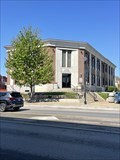
|   Wayne County Courthouse - Monticello, KY Wayne County Courthouse - Monticello, KY
in Courthouses Wayne County Courthouse located in Monticello, KY. posted by:  Team Geologynut Team Geologynut location: Kentucky date approved: 04/20/2023 last visited: never |
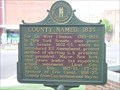
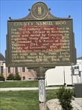 view gallery view gallerySE9.5 km |  County Named. 1800 #804 - Monticello, KY County Named. 1800 #804 - Monticello, KY
in Kentucky Historical Markers Kentucky historical marker #804 on the grounds of the Wayne County Courthouse in Monticello, KY. posted by: Team Geologynut location: Kentucky date approved: 04/21/2023 last visited: never |
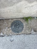 view gallery view gallerySE9.5 km |  E 44 RESET (GB1024) - Monticello - Wayne County, KY E 44 RESET (GB1024) - Monticello - Wayne County, KY
in U.S. Benchmarks This USC&G benchmark is located in the sidewalk in front of the Monticello Banking Co. building across the street from the Wayne Co. Courthouse in Monticello, KY. posted by: Team Geologynut location: Kentucky date approved: 04/23/2023 last visited: never |
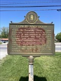 view gallery view gallerySE9.7 km | Coach and Four #818 - Monticello, KY in Kentucky Historical Markers This Kentucky Historical Marker #818 is located off N. Main St. in Monticello, KY. posted by: Team Geologynut location: Kentucky date approved: 04/19/2023 last visited: never |
 view gallery view gallery E10 km E10 km
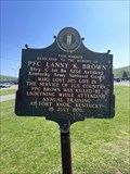
| PFC Lanny K. Brown - Monticello, KY in Kentucky Historical Markers A Kentucky historical marker in front of the National Guard Armory in Monticello, KY dedicated to the memory of PFC Lanny K. Brown. posted by: Team Geologynut location: Kentucky date approved: 04/21/2023 last visited: never |
 view gallery view gallery N13 km N13 km
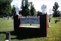
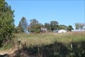
|  Military Spring Cemetery - Jabez, Russell County, Kentucky, U.S.A. Military Spring Cemetery - Jabez, Russell County, Kentucky, U.S.A.
in Worldwide Cemeteries Military Spring Cemetery is a rural cemetery located in Jabez, Kentucky. posted by:  dawn's light dawn's light location: Kentucky date approved: 07/30/2007 last visited: never |
 view gallery view gallery W13.2 km W13.2 km
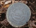
| Barstehunbre's Pumpkin Creek Survey Disk in U.S. Benchmarks This is a U.S. Army Corp of Engineers survey disk marker posted by: barstehunbre location: Kentucky date approved: 03/21/2010 last visited: never |
 view gallery view gallery NE16.6 km NE16.6 km
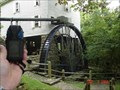
|  Mill Springs Mill, Monticello, KY Mill Springs Mill, Monticello, KY
in Water Mills Walking the grounds of Mill Springs Park will take your mind and soul to another time - the past. Old battlefields, new innovations and extensive restorations, make up much of Mill Springs Park's history. By taking a stroll through Mill Spring's Park, one is instantly immersed in the culture and history of another time. posted by: Lord Elwood location: Kentucky date approved: 09/05/2006 last visited: 09/05/2006 |
 view gallery view galleryNE16.6 km | Mill Springs Mill, Monticello, KY in Working Water Wheels Walking the grounds of Mill Springs Park will take your mind and soul to another time - the past. Old battlefields, new innovations and extensive restorations, make up much of Mill Springs Park's history. By taking a stroll through Mill Spring's Park, one is instantly immersed in the culture and history of another time. posted by: Lord Elwood location: Kentucky date approved: 09/05/2006 last visited: 09/05/2006 |
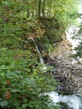 view gallery view galleryNE16.6 km |  Mill Springs Mill Waterfall Mill Springs Mill Waterfall
in Waterfalls Twin waterfalls that feed the world's largest water wheel. posted by: Lord Elwood location: Kentucky date approved: 09/05/2006 last visited: 09/05/2006 |
![Image for Coopersville, KY - 42611 [Retired]](https://img.geocaching.com/waymarking/small/6352ac98-27ca-4fe1-9b47-47dd2d22d438.JPG) view gallery view gallerySE22 km |  Coopersville, KY - 42611 [Retired] Coopersville, KY - 42611 [Retired]
in U.S. Post Offices Almost gone... posted by: bluesneaky location: Kentucky date approved: 12/01/2011 last visited: never |
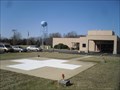 view gallery view gallery NW23.7 km NW23.7 km
|  Russell County Hospital Landing Pad, Russell Springs, Kentucky Russell County Hospital Landing Pad, Russell Springs, Kentucky
in Helicopter Landing Pads Located on the campus of the Russell County Hospital in Russell Springs, Kentucky, this landing pad provides emergency transport and first responder services for the citizens of the region. posted by: PersonsMD location: Kentucky date approved: 03/19/2010 last visited: 03/18/2010 |
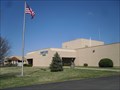 view gallery view galleryNW23.7 km |  Russell County Hospital, Russell Springs, Kentucky Russell County Hospital, Russell Springs, Kentucky
in Hospitals Russell County Hospital is a facility that provides medical services to the citizens in the Russell Springs and Russell County, Kentucky region and is a critical access hospital. posted by: PersonsMD location: Kentucky date approved: 03/20/2010 last visited: 03/20/2010 |
 view gallery view gallery SW25.3 km SW25.3 km
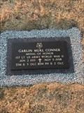
|  Garlin Murl Conner-Albany, KY Garlin Murl Conner-Albany, KY
in Medal Of Honor Resting Places World War II Medal of Honor Recipient for action at Houssen, France on January 24, 1945. He was awarded the Medal of Honor on June 26, 2018. He is buried in Memorial Hill Cemetery, Albany, KY. posted by: Don.Morfe location: Kentucky date approved: 12/21/2018 last visited: 12/07/2021 |
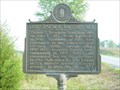
 view gallery view gallerySW25.9 km | Clinton County Named, 1835 in Kentucky Historical Markers A historical marker on the square in Albany, KY. posted by: ggmorton location: Kentucky date approved: 09/18/2007 last visited: 09/02/2007 |
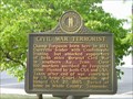 view gallery view gallerySW26.1 km | Civil War Terrorist in Kentucky Historical Markers A marker on the square in Albany. posted by: ggmorton location: Kentucky date approved: 10/17/2007 last visited: 09/02/2007 |
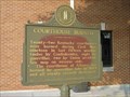 view gallery view gallerySW26.1 km | Courthouse Burned in Kentucky Historical Markers A marker on the square in Albany. posted by: ggmorton location: Kentucky date approved: 10/17/2007 last visited: 09/02/2007 |
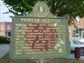 view gallery view gallerySW26.1 km | Pioneer Settler in Kentucky Historical Markers A marker on the square in Albany. posted by: ggmorton location: Kentucky date approved: 10/17/2007 last visited: 09/02/2007 |
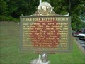 view gallery view gallerySW26.9 km | Clear Fork Baptist Church in Kentucky Historical Markers A marker in Albany about an old church. posted by: ggmorton location: Kentucky date approved: 10/17/2007 last visited: 09/02/2007 |
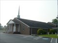 view gallery view gallerySW26.9 km |  Clear Fork Baptist Church - Albany, KY Clear Fork Baptist Church - Albany, KY
in Baptist Churches Clear Fork Baptist Church is an independent Baptist church in Albany, KY. posted by: ggmorton location: Kentucky date approved: 06/09/2021 last visited: 09/02/2007 |
 view gallery view gallerySW28 km | Governor's Birthplace in Kentucky Historical Markers A marker on the side of the road not far from the Tennessee Kentucky border. posted by: ggmorton location: Kentucky date approved: 10/17/2007 last visited: 09/02/2007 |
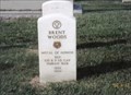 view gallery view galleryNE29 km | Brent Woods-Nancy, KY in Medal Of Honor Resting Places Indian Campaigns Medal of Honor Recipient for action in New Mexico on August 19, 1881. He is buried in Mill Springs National Cemetery, Nancy, KY in Section A, Site 930. posted by: Don.Morfe location: Kentucky date approved: 06/24/2018 last visited: 12/12/2021 |
 view gallery view galleryNE29.3 km |  Mail Pouch barn - MPB 17-100-01 Mail Pouch barn - MPB 17-100-01
in Barns MPB 17-100-01, Pulaski County, KY posted by: Wallyum location: Kentucky date approved: 03/30/2021 last visited: never |
![Image for Bronston, KY - 42518 [Retired]](https://img.geocaching.com/waymarking/small/04e0174a-1e40-4b59-96c4-63173d23a069.JPG) view gallery view galleryNE31.9 km | Bronston, KY - 42518 [Retired] in U.S. Post Offices The old post office had the best view... posted by: bluesneaky location: Kentucky date approved: 12/01/2011 last visited: never |
 view gallery view gallery S31.9 km S31.9 km
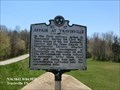
|  Affair at Travisville - Byrdstown, TN Affair at Travisville - Byrdstown, TN
in Official Local Tourism Attractions Site of the first skirmish in Tennessee, large numbers of Confederate troops gathered at Travisville. A Federal force surprised the Confederates there. posted by: Don.Morfe location: Tennessee date approved: 02/23/2023 last visited: 02/24/2023 |
|