Courthouse Burned
Posted by: Groundspeak Premium Member ggmorton
N 36° 41.433 W 085° 08.136
16S E 666565 N 4062164
A marker on the square in Albany.
Waymark Code: WM2637
Location: Kentucky, United States
Date Posted: 09/10/2007
Published By:Groundspeak Premium Member snfromky
Views: 26

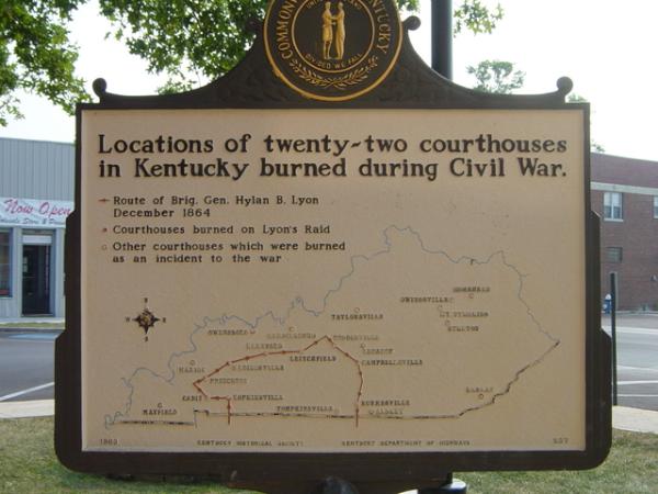
Twenty-two Kentucky courthouses were burned during Civil War, nineteen in last fifteen months: twelve by Confederates, eight by guerrillas, two by Union accident. See map on reverse side.

The courthouse at Albany was burned by guerrillas late in 1864 and all county records destroyed.
Marker Name: Courthouse Burned

Marker Location: City

Type of Marker: Battle (war)

Marker Number (for official markers): 597

Group(s) Responsible for placing Marker:
Kentucky Historical Society Kentucky Department of Highways


Visit Instructions:
A picture of the site or anything specific to the text on marker.
Search for...
Geocaching.com Google Map
Google Maps
MapQuest
Bing Maps
Nearest Waymarks
Nearest Kentucky Historical Markers
Nearest Geocaches
Create a scavenger hunt using this waymark as the center point
Recent Visits/Logs:
Date Logged Log User Rating  
ggmorton visited Courthouse Burned 09/02/2007 ggmorton visited it

View all visits/logs