 view gallery view gallery SW0 km SW0 km
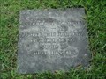
|   Bicentennial Time Capsule - Stuart, Virginia Bicentennial Time Capsule - Stuart, Virginia
in Time Capsules Bicentennial Time Capsule on the grounds on the Patrick County Courthouse in Stuart, Virginia posted by:  Sneakin Deacon Sneakin Deacon location: Virginia date approved: 07/11/2006 last visited: 04/09/2012 |
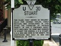 view gallery view gallerySW0 km |  Stuart Stuart
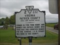
in Virginia Historical Markers Stuart is the County Seat of Patrick County, Virginia posted by: Sneakin Deacon location: Virginia date approved: 07/11/2006 last visited: 11/09/2020 |
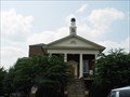 view gallery view gallerySW0 km |  Patrick County Courthouse Patrick County Courthouse
in U.S. National Register of Historic Places The Partick County Courthouse is located in Stuart Virginia posted by: Sneakin Deacon location: Virginia date approved: 07/11/2006 last visited: 11/09/2020 |
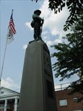 view gallery view gallerySW0 km |  Memorial to Confederate Soldiers of Patrick County - Stuart, Virginia Memorial to Confederate Soldiers of Patrick County - Stuart, Virginia
in American Civil War Monuments and Memorials Memorial to the Memory of General J.E.B. Stuart and the Confederate Soldiers of Patrick County, Virginia posted by: Sneakin Deacon location: Virginia date approved: 07/11/2006 last visited: 11/09/2020 |
 view gallery view gallery NW9.7 km NW9.7 km
|  Lovers Leap Overlook Lovers Leap Overlook
in Scenic Roadside Look-Outs Lovers Leap Overlook is located on Route 58 west of Stuart, near the top of Lovers Leap Mountain in Patrick County, Virginia posted by: Sneakin Deacon location: Virginia date approved: 07/24/2006 last visited: 03/07/2019 |
 view gallery view gallery N10 km N10 km
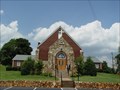
|  Buffalo Ridge Pentecostal Holiness Church - VA Buffalo Ridge Pentecostal Holiness Church - VA
in Country Churches Buffalo Ridge Pentecostal Holiness Church is located on Route 8 in the Buffalo Ridge Community of Patrick County, Virginia. posted by: Sneakin Deacon location: Virginia date approved: 07/24/2006 last visited: 10/09/2012 |
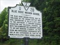 view gallery view galleryN10.8 km | Blue Ridge Mission School in Virginia Historical Markers The Blue Ridge Mission School functioned in Patrick County from 1916 through 1941. posted by: Sneakin Deacon location: Virginia date approved: 07/24/2006 last visited: 04/09/2012 |
 view gallery view gallery SE10.9 km SE10.9 km
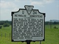
| Reynolds Homestead in Virginia Historical Markers Reynolds Homestead is the Birthplace of Tobacco manufacturer R. j. Reynolds posted by: Sneakin Deacon location: Virginia date approved: 07/11/2006 last visited: 04/09/2012 |
 view gallery view galleryNW11.3 km |  Vesta, VA 24177 Vesta, VA 24177
in U.S. Post Offices Vesta, VA 24177 posted by:  SportsPhotoGuy SportsPhotoGuy location: Virginia date approved: 06/13/2010 last visited: 12/16/2015 |
 view gallery view gallery E11.3 km E11.3 km
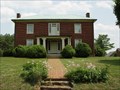
| Reynolds Homestead in U.S. National Register of Historic Places Birthplace of tobacco manufacturer R. J. Reynolds posted by: Sneakin Deacon location: Virginia date approved: 07/11/2006 last visited: 04/09/2012 |
 view gallery view gallery S11.6 km S11.6 km
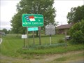
| Virginia Patrick County / North Carolina in Virginia Historical Markers Z232 - Virginia Patrick County / North Carolina on Hwy 8 at the Va./NC border posted by: fatcat161 location: Virginia date approved: 05/15/2013 last visited: never |
 view gallery view galleryS11.6 km |  Patrick Co. Va. / Stokes Co. NC on NC/VA Hwy. 8 Patrick Co. Va. / Stokes Co. NC on NC/VA Hwy. 8
in Border Crossings Border crossing between NC and Va. posted by: fatcat161 location: North Carolina date approved: 05/14/2013 last visited: never |
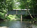
 view gallery view galleryN13.7 km |  Jack's Creek Covered Bridge Jack's Creek Covered Bridge
in Covered Bridges The Jack's Creek Covered Bridge is located on Jack's Creek Road .2 mile west of Route 8 in Patrick County, Virginia posted by: Sneakin Deacon location: Virginia date approved: 07/24/2006 last visited: 01/04/2012 |
 view gallery view galleryNW15.1 km | Meadows of Dan, VA 24120 in U.S. Post Offices Meadows of Dan, VA posted by: SportsPhotoGuy location: Virginia date approved: 06/13/2010 last visited: 04/09/2012 |
 view gallery view galleryN15.3 km | Bob White Covered Bridge in Covered Bridges ****** ON SEPTEMBER 29, 2015, THE BOB WHITE COVERED BRIDGE WAS DESTROYED BY THE FLOODING OF THE SMITH RIVER.***** Bob White Covered Bridge is located in just off of Elamsville Road about a mile and a half east of Virginia Route 8. posted by: Sneakin Deacon location: Virginia date approved: 07/24/2006 last visited: 10/09/2012 |
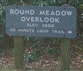 view gallery view galleryNW15.9 km |  Round Meadow Overlook Round Meadow Overlook
in Elevation Signs Located on the Blue Ridge Parkway. posted by: fatcat161 location: Virginia date approved: 11/02/2008 last visited: 11/01/2008 |
 view gallery view galleryN16.4 km | Woolwine United Methodist Church - VA in Country Churches This Church is located at the intersection of Route 8 and Route 40 in the Woolwine Community of Patrick County, Virginia posted by: Sneakin Deacon location: Virginia date approved: 07/24/2006 last visited: 12/30/2007 |
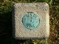 view gallery view galleryNW16.9 km |  USDI NPS - T 98 - Patrick Co. Va USDI NPS - T 98 - Patrick Co. Va
in U.S. Benchmarks USDI NPS just off the Blue Ridge Parkway. posted by: fatcat161 location: Virginia date approved: 11/06/2008 last visited: 06/26/2010 |
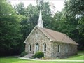 view gallery view galleryNW16.9 km | Mayberry Presbyterian Church - VA in Country Churches This historic rock church stands adjacent to the Blue Ridge Parkway, just south of the community of Meadow of Dan in Patrick County, Virginia posted by: Sneakin Deacon location: Virginia date approved: 07/24/2006 last visited: 10/09/2012 |
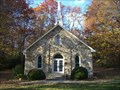 view gallery view galleryNW16.9 km | Mayberry Presbyterian Church in U.S. National Register of Historic Places Mayberry Presbyterian Church is one of the five historic rock churches located in the tri-county area of Carroll, Floyd, and Patrick Counties of southwestern Virginia.
posted by: fatcat161 location: Virginia date approved: 11/04/2008 last visited: 10/09/2012 |
 view gallery view galleryNW17.1 km |  Mabry Mill- Va Mabry Mill- Va
in Wikipedia Entries
Mabry Mill is one of the most photographed places on the Blue Ridge Parkway. It is located at milepost 176.
posted by: Norfolk12 location: Virginia date approved: 05/05/2008 last visited: 07/25/2024 |
 view gallery view galleryNW17.1 km |  Mabry Mill Mabry Mill
in Water Mills Mabry Mill is one of the most photographed places on the Blue Ridge Parkway. It is located at milepost 176. posted by: Sneakin Deacon location: Virginia date approved: 07/24/2006 last visited: 07/25/2024 |
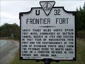 view gallery view galleryE19.6 km | Frontier Fort in Virginia Historical Markers Located on Hwy. 58 east in Patrick Co. posted by: 3newsomes location: Virginia date approved: 11/08/2009 last visited: 04/09/2012 |
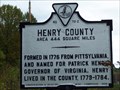 view gallery view galleryE20 km | Henry County / Patrick County in Virginia Historical Markers Located on Hwy. 58 at the Henry Co./Patrick Co. line posted by: 3newsomes location: Virginia date approved: 11/08/2009 last visited: 04/09/2012 |
 view gallery view galleryN20.1 km |  Old Station - Rocky Knob Information Station Old Station - Rocky Knob Information Station
in Vintage Gas Stations This Information Station at mile marker 169 on the Blue Ridge Parkway is a remnant of the area's past. posted by: miatabug location: Virginia date approved: 12/18/2011 last visited: 11/12/2017 |
|