 view gallery view gallery W0.2 km W0.2 km
|   Old Municipal Tank, Liberty, North Carolina Old Municipal Tank, Liberty, North Carolina
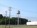
in Water Towers Old style, six-legged steel trusswork structure, about 125 feet high, located in the center of town. posted by:  PFF PFF location: North Carolina date approved: 07/10/2006 last visited: 01/22/2017 |
 view gallery view gallery SE1.4 km SE1.4 km
| Liberty Municipal Water Tower, Liberty, North Carolina in Water Towers Tall tower in a small town. posted by:  showbizkid showbizkid location: North Carolina date approved: 06/20/2006 last visited: 11/28/2015 |
 view gallery view gallery NE2.9 km NE2.9 km
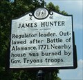
|  James Hunter, Marker K-61 James Hunter, Marker K-61
in North Carolina Historical Markers James Hunter was a prominent member of the Regulator Movement prior to the American Revolution. posted by: showbizkid location: North Carolina date approved: 06/18/2006 last visited: 10/19/2018 |
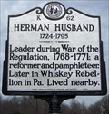 view gallery view galleryW6.6 km | K 62 Herman Husband 1724-1795 in North Carolina Historical Markers A 2007 NC Historical Marker in Randolph Co. posted by: Padon location: North Carolina date approved: 01/30/2008 last visited: 12/17/2016 |
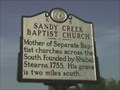 view gallery view galleryW6.6 km | K-5 Sandy Creek Baptist Church in North Carolina Historical Markers Mother Of the Southern Baptist churches. posted by: ridebmw location: North Carolina date approved: 04/16/2006 last visited: 12/17/2016 |
 view gallery view gallery S6.8 km S6.8 km
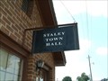
|  Town Hall, Staley, North Carolina Town Hall, Staley, North Carolina
in City and Town Halls A tiny Town Hall in a tiny town in North Carolina. posted by: showbizkid location: North Carolina date approved: 06/20/2006 last visited: 09/11/2016 |
 view gallery view galleryNE6.9 km |  Shady Oak Store, near Siler City, NC, USA Shady Oak Store, near Siler City, NC, USA
in Unoccupied Buildings, Shacks, and Cabins Old country store on NC 49 harks of days gone by when there were Mom and Pop gas stations all over the countryside. posted by: NCDaywalker location: North Carolina date approved: 04/01/2018 last visited: 01/06/2022 |
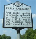 view gallery view galleryNE6.9 km | Early Railroads, Marker G-13 in North Carolina Historical Markers This marker commemorates the first meeting held in North Carolina to discuss railroads. posted by: showbizkid location: North Carolina date approved: 06/18/2006 last visited: 01/06/2022 |
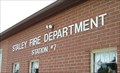 view gallery view galleryS6.9 km |  Staley Fire Department, Station #7, Staley, North Carolina Staley Fire Department, Station #7, Staley, North Carolina
in Firehouses Staley is a small town of only 355 people. This station serves the town and surrounding rural area. It is designated Randolph County Fire Station 7. posted by: showbizkid location: North Carolina date approved: 07/25/2006 last visited: 02/22/2020 |
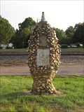 view gallery view galleryS7.2 km |  Boone Trail Marker #33 - Staley NC Boone Trail Marker #33 - Staley NC
in Daniel Boone Trail Markers Pride of Staley - Boone Trail Marker in Staley, NC near Short St on old US 421. posted by: david28377 location: North Carolina date approved: 07/06/2013 last visited: 05/31/2016 |
 view gallery view gallery N7.9 km N7.9 km
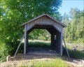
|  Kimesville Covered Bridge Kimesville Covered Bridge
in Covered Bridges The Kimesville Covered Bridge is a old wooden bridge located in Randolph County off of Humble Road in Liberty, NC. posted by: NAVY-guy location: North Carolina date approved: 05/30/2020 last visited: never |
 view gallery view gallery NW9 km NW9 km
| K-18 Trading Path in North Carolina Historical Markers K-18 Trading Path posted by: ridebmw location: North Carolina date approved: 04/16/2006 last visited: 09/18/2018 |
 view gallery view gallery E9 km E9 km
|  Flint Ridge UMC - Chatham County, North Carolina Flint Ridge UMC - Chatham County, North Carolina
in Country Churches Founded in 1830, this rural church sits in northern Chatham County, near the Alamance County line. posted by: PFF location: North Carolina date approved: 07/19/2006 last visited: never |
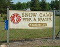 view gallery view galleryNE9.5 km | Snow Camp Fire and Rescue, Station 14 in Firehouses Snow Camp is a rural fire district in Alamance County, North Carolina. posted by: showbizkid location: North Carolina date approved: 07/20/2006 last visited: 01/06/2022 |
 view gallery view galleryNW9.7 km | Julian Vol. Fire Dept. in Firehouses This community fire department in Julian, NC serves the citizens of Julian and surrounding area of Guilford County. posted by: NCDaywalker location: North Carolina date approved: 12/24/2016 last visited: 10/19/2018 |
 view gallery view galleryE12.1 km | Sylvan School 1912-1960 in North Carolina Historical Markers Oldest rural school in Alamance County in continuous operation, located near Snow Camp, NC. posted by: PFF location: North Carolina date approved: 07/18/2006 last visited: 12/28/2018 |
 view gallery view galleryE12.1 km | Cane Creek Friends Meeting, Snow Camp, North Carolina in Country Churches Cane Creek Friends Meeting is a historic Quaker Meeting (church building) in rural Chatham County, North Carolina. It is the site of the first monthly meeting of the Friends in North Carolina in 1751. posted by: showbizkid location: North Carolina date approved: 07/19/2006 last visited: 10/25/2017 |
 view gallery view galleryE12.1 km | Cane Creek Meeting G-69 in North Carolina Historical Markers This very old Quaker congregation helped start the Sylvan Academy in 1866. Very interesting cemetery on the grounds. posted by: PFF location: North Carolina date approved: 07/18/2006 last visited: 10/25/2017 |
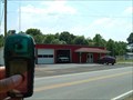 view gallery view galleryE13.2 km | Snow Camp Fire and Rescue, Station 6 in Firehouses A small rural firehouse in Alamance County, North Carolina. posted by: showbizkid location: North Carolina date approved: 06/02/2006 last visited: 04/30/2021 |
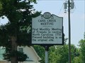
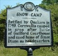 view gallery view galleryE13.5 km | Snow Camp, Marker G-76 in North Carolina Historical Markers The location of an early Quaker settlement and Revolutionary War site. This marker is on Snow Camp Road, just south of the Greensboro-Chapel Hill Road. posted by: showbizkid location: North Carolina date approved: 05/31/2006 last visited: 12/28/2018 |
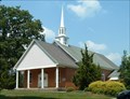 view gallery view gallerySE14.2 km | Rocky River Baptist Church, Siler City, North Carolina in Country Churches This Country Church is Rocky River Baptist Church in the rural area a few miles north of Siler City, NC. A state historic marker notes that this church was the site of meeting of the Regulators, a pre-Revolutionary War, anti-colonial group who eventually went into armed conflict with the colonial militia over taxes and corrupt officials. posted by: showbizkid location: North Carolina date approved: 07/19/2006 last visited: 12/17/2017 |
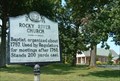 view gallery view gallerySE14.2 km | Rocky River Church, Marker H-73 in North Carolina Historical Markers Rocky River Church was established in 1756. Members of the Regulator Movement met at the old church at this location. posted by: showbizkid location: North Carolina date approved: 07/19/2006 last visited: 12/17/2017 |
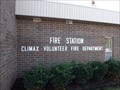 view gallery view galleryNW14.3 km | Fire Station Climax Volunteer Fire Department in Firehouses Located near the intersection of NC 62 and NC 22, the station is at the crossroads of a large part of the population of NC. Serving residents in Guilford and Randolph Counties, they are an integral part of the community they serve, bravely and ably. posted by: NCDaywalker location: North Carolina date approved: 12/08/2015 last visited: 12/04/2017 |
 view gallery view gallery SW14.5 km SW14.5 km
| McCrary Hosiery Company Tank, Ramseur, NC in Water Towers A 120-foot tall industrial tank at a closed hosiery plant along US-64. posted by: PFF location: North Carolina date approved: 05/27/2007 last visited: 02/19/2012 |
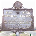 view gallery view gallerySW14.5 km |  US Hwy 64 - Ramseur, NC US Hwy 64 - Ramseur, NC
in Blue Star Memorial Highway Markers Hwy 64 Ramseur, NC posted by: Padon location: North Carolina date approved: 01/10/2008 last visited: 04/14/2017 |
|