 view gallery view gallery NW5.1 km NW5.1 km
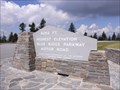
|   Highest Elevation - BlueRidge Parkway Highest Elevation - BlueRidge Parkway
in Elevation Signs The highest point of the BlueRidge Parkway is found at this overlook (Milepost 431.0). posted by:  TheGeoGnomes TheGeoGnomes location: North Carolina date approved: 08/12/2011 last visited: 05/27/2017 |
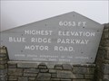 view gallery view galleryNW5.1 km |  Blue Ridge Parkway - Highest Point - North Carolina, USA. Blue Ridge Parkway - Highest Point - North Carolina, USA.
in National Scenic Byways Richland Balsam Overlook. Altitude 6,053 feet, the highest point on the Blue Ridge Parkway motor road. Four States can be viewed from this location. Located at Milepost 431.4, North Carolina. posted by: veritas vita location: North Carolina date approved: 05/02/2015 last visited: 05/27/2017 |
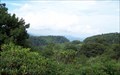
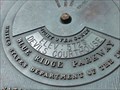 view gallery view gallery SE6 km SE6 km
| Devil's Courthouse, Blue Ridge Parkway, milemarker 422 in Elevation Signs Elevation is posted on horizon viewer information plaque. posted by: NCDaywalker location: North Carolina date approved: 07/17/2014 last visited: 05/27/2017 |
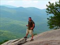
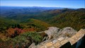 view gallery view gallerySE6 km |  Devil's Courthouse, Blue Ridge Parkway, milemarker 422 Devil's Courthouse, Blue Ridge Parkway, milemarker 422
in Scenic Overlooks The reward for a half mile long and arduous climb to the top of The Devil's Courthouse is a spectacular view of the surrounding mountains, posted by: NCDaywalker location: North Carolina date approved: 07/17/2014 last visited: 05/27/2017 |
 view gallery view gallery E9.8 km E9.8 km
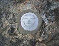
|  Graveyard Horizontal Control - Brevard, NC Graveyard Horizontal Control - Brevard, NC
in U.S. Benchmarks Horizontal Control disk at the Graveyard Overlook at Blue Ridge Parkway milepost 418.8. posted by: hummerstation location: North Carolina date approved: 07/28/2013 last visited: never |
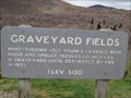 view gallery view galleryE9.8 km | Graveyard Fields - Brevard, North Carolina - 5,120 feet. in Elevation Signs Graveyard Fields, at an elevation of 5,120 feet - Named for the tree stumps left after a storm or fire. Listed as one of the most popular hiking areas in the Blue Ridge Mountains. Located at Mile Post 418, Brevard, North Carolina. posted by: veritas vita location: North Carolina date approved: 05/17/2015 last visited: 10/12/2019 |
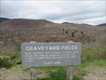 view gallery view galleryE9.8 km | Blue Ridge Parkway - Graveyard Fields - Mile Post 418, North Carolina, USA. in National Scenic Byways Graveyard Fields - Named for the tree stumps left after a storm or fire, that left the area looking like a graveyard. Listed as one of the most popular hiking areas on the Blue Ridge Parkway. Located at Mile Post 418, Brevard, North Carolina. posted by: veritas vita location: North Carolina date approved: 05/17/2015 last visited: 10/12/2019 |
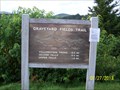 view gallery view galleryE9.8 km |  Graveyard Fields Trailhead - Brevard, NC Graveyard Fields Trailhead - Brevard, NC
in Hiking and walking trailheads The Graveyard Fields Trailhead and parking area is located at Blue Ridge Parkway milepost 418.8. posted by: hummerstation location: North Carolina date approved: 07/29/2013 last visited: 10/12/2019 |
 view gallery view galleryE9.8 km |  Graveyard Fields Overlook - Brevard, NC Graveyard Fields Overlook - Brevard, NC
in Scenic Roadside Look-Outs The Graveyard Fields Overlook and parking area is located at Blue Ridge Parkway milepost 418.8. posted by: hummerstation location: North Carolina date approved: 09/08/2013 last visited: 10/12/2019 |
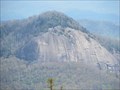 view gallery view galleryE11.6 km | Blue Ridge Parkway - Looking Glass Rock - Mile Post 417 - North Carolina, USA. in National Scenic Byways Looking Glass Rock. So named because it reflects light brilliantly when water and ice are on the rock’s granite face. Located at Mile post 417 on the Blue Ridge Parkway, North Carolina. posted by: veritas vita location: North Carolina date approved: 04/29/2015 last visited: 06/10/2018 |
 view gallery view galleryE11.6 km | Looking Glass Rock - Blue Ridge Parkway - Mile Post 417 - North Carolina, USA. in Scenic Roadside Look-Outs Looking Glass Rock - So named because it reflects light brilliantly when water & ice are on the rock’s massive granite face. Located at Mile post 417 on the Blue Ridge Scenic Parkway, North Carolina. posted by: veritas vita location: North Carolina date approved: 04/29/2015 last visited: 06/10/2018 |
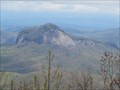 view gallery view galleryE11.6 km |  Looking Glass Rock - Blue Ridge Parkway - North Carolina, USA. Looking Glass Rock - Blue Ridge Parkway - North Carolina, USA.
in Wikipedia Entries Looking Glass Rock - So named because it reflects light brilliantly when water & ice are on the rock’s massive granite face. Located at Mile post 417 on the Blue Ridge Scenic Parkway, North Carolina. posted by: veritas vita location: North Carolina date approved: 04/29/2015 last visited: 06/10/2018 |
 view gallery view gallery W14.3 km W14.3 km
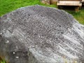
|  Judaculla Rock Judaculla Rock
in New World Ancient Evidence Soapstone covered with Cherokee petroglyphs. posted by: vhasler location: North Carolina date approved: 07/20/2013 last visited: 06/07/2019 |
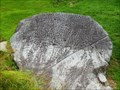 view gallery view galleryW14.3 km |  Judaculla Rock - Cullowhee, NC Judaculla Rock - Cullowhee, NC
in U.S. National Register of Historic Places Soapstone covered with Cherokee petroglyphs. posted by: vhasler location: North Carolina date approved: 07/20/2013 last visited: 06/07/2019 |
 view gallery view galleryW14.3 km |  Judaculla Rock Judaculla Rock
in Pictographs The Cherokee carved petroglyphs into a surface soapstone along a hunting trail. posted by: vhasler location: North Carolina date approved: 07/20/2013 last visited: 06/07/2019 |
 view gallery view galleryE14.6 km |  Looking Glass Rock - Satellite Oddity - Blue Ridge Parkway - North Carolina, USA. Looking Glass Rock - Satellite Oddity - Blue Ridge Parkway - North Carolina, USA.
in Satellite Imagery Oddities Looking Glass Rock - So named because it reflects light brilliantly when water & ice are on the rock’s 4,000 feet tall granite face. Featured on Virtual Globetrotting, viewed from Mile post 417 on the Blue Ridge Scenic Parkway, North Carolina. posted by: veritas vita location: North Carolina date approved: 04/30/2015 last visited: 09/30/2020 |
 view gallery view galleryE14.6 km |  Looking Glass Rock - Pluton Monolith - Blue Ridge Parkway - North Carolina, USA Looking Glass Rock - Pluton Monolith - Blue Ridge Parkway - North Carolina, USA
in Places of Geologic Significance Geological name 'Pluton Monolith' Local name, Looking Glass Rock, so named because it reflects light brilliantly when water & ice are on the rock’s 4,000 feet tall granite face. Viewed from the Blue Ridge Scenic Parkway, North Carolina. posted by: veritas vita location: North Carolina date approved: 05/01/2015 last visited: 09/30/2020 |
 view gallery view galleryE14.8 km | Looking Glass Rock Trail in Scenic Hikes Park at the Looking Glass Trail parking area (N 35 17.459,W082 46.596) follow the trail to the top of the rock. posted by: footTRAX location: North Carolina date approved: 08/05/2006 last visited: 06/09/2007 |
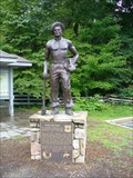 view gallery view galleryE15.6 km |  Camp John Rock CCC, near Breavrd, NC Camp John Rock CCC, near Breavrd, NC
in Civilian Conservation Corps This monument like several others across the country was dedicated to the hard work and effort put into many public works projects throughout the nation in the Great Depression era. posted by: NCDaywalker location: North Carolina date approved: 07/20/2014 last visited: 07/20/2014 |
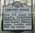 view gallery view galleryE16.1 km |  FIRST - Forestry School - Pisgah Forest NC FIRST - Forestry School - Pisgah Forest NC
in First of its Kind Forestry School-First U.S. school of forestry, Established 1898 by Dr. C.A. Schenck posted by:  Don.Morfe Don.Morfe location: North Carolina date approved: 10/19/2022 last visited: 10/19/2022 |
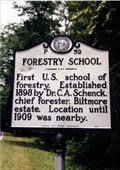 view gallery view galleryE16.1 km |  Forestry School-P 59 Forestry School-P 59
in North Carolina Historical Markers On US 276 near the Blue Ridge Parkway. posted by: Markerman62 location: North Carolina date approved: 03/11/2015 last visited: 03/27/2015 |
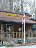 view gallery view galleryNW16.4 km |  Moonshine Creek Campground Moonshine Creek Campground
in Campgrounds Great destination campground to explore the beatuy that is Western NC. posted by:  Capt Kirk Capt Kirk location: North Carolina date approved: 01/09/2006 last visited: 05/18/2011 |
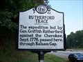 view gallery view galleryNW16.6 km | P 42 Rutherford Trace in North Carolina Historical Markers 1776 Expedition against the Cherokee passed here posted by: Padon location: North Carolina date approved: 07/21/2008 last visited: 08/16/2021 |
 view gallery view galleryNW16.6 km |  Great Smoky Mountains Expressway Rest Area - NC Great Smoky Mountains Expressway Rest Area - NC
in Highway Rest Areas Serves both directions of the US 23. posted by: ChapterhouseInc location: North Carolina date approved: 07/16/2010 last visited: 09/30/2020 |
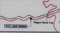 view gallery view galleryE16.9 km |  You Are Here - Cradle of Forestry - Blue Ridge Mountains, North Carolina, USA. You Are Here - Cradle of Forestry - Blue Ridge Mountains, North Carolina, USA.
in 'You Are Here' Maps Mount Pisgah in the Blue Ridge Mountains. The Birthplace of Forest Conservation in America. Located at Milepost 408, Blue Ridge Parkway, near Asheville, North Carolina. posted by: veritas vita location: North Carolina date approved: 05/05/2015 last visited: 05/05/2015 |
|