 view gallery view gallery NW0 km NW0 km
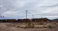
|   BNSF Mainline ~ Goffs, California BNSF Mainline ~ Goffs, California
in Active Rail Locations The grade crossing at Goffs on the BNSF mainline is a good place to see some impressive front-end power in action. posted by:  brwhiz brwhiz location: California date approved: 10/30/2012 last visited: 02/13/2015 |
 view gallery view gallery W0.3 km W0.3 km
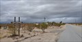
|  Goffs, California Goffs, California
in Wikipedia Entries Goffs is a ghost town west of Needles on an old (pre-1931) alignment of Historic Route 66. posted by: brwhiz location: California date approved: 06/04/2011 last visited: 02/13/2015 |
 view gallery view galleryW0.3 km |  Goffs, California Goffs, California
in Ghost Towns Goffs is a ghost town west of Needles on an old (pre-1931) alignment of Historic Route 66. posted by: brwhiz location: California date approved: 06/04/2011 last visited: 12/18/2021 |
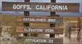 view gallery view galleryW0.3 km |  Goffs, California - Population 23 Goffs, California - Population 23
in Population Signs Goffs is a ghost town west of Needles on an old (pre-1931) alignment of Historic Route 66. posted by: brwhiz location: California date approved: 06/04/2011 last visited: 12/18/2021 |
 view gallery view galleryW0.3 km |  Goffs, California - Elevation 2595 Goffs, California - Elevation 2595
in Elevation Signs Goffs is a ghost town west of Needles on an old (pre-1931) alignment of Historic Route 66. posted by: brwhiz location: California date approved: 06/04/2011 last visited: 02/09/2018 |
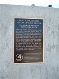 view gallery view galleryW0.3 km |  Army Camp at Goffs Army Camp at Goffs
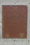
in E Clampus Vitus Historical Markers Another marker from the Desert Training Center,
California-Arizona Maneuver Area posted by:  leadhiker leadhiker location: California date approved: 05/23/2010 last visited: 02/13/2015 |
 view gallery view galleryW0.3 km |  Goffs Desert Training Center Goffs Desert Training Center
in Military Installations This WWII Military Installation was located in the immediate vicinity of Goffs, California. posted by: brwhiz location: California date approved: 11/11/2012 last visited: 02/13/2015 |
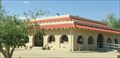
 view gallery view galleryW0.3 km |  Goffs Schoolhouse Goffs Schoolhouse
in Route 66 - The Mother Road Goffs Schoolhouse operated from 1914 to 1937, was restored in 1998, and was recently added to the National Historic Register. posted by: TravisGood location: California date approved: 03/17/2007 last visited: 02/13/2015 |
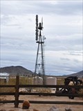 view gallery view galleryW0.3 km |  Goffs Schoolhouse Windmill Goffs Schoolhouse Windmill
in Windmills This windmill is located on the grounds of the Goffs Schoolhouse Museum and Cultural Center located at the junction of Goffs Road and Lanfair Road about 30 miles east of Needles, California. posted by: brwhiz location: California date approved: 11/10/2012 last visited: 12/18/2021 |
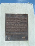 view gallery view galleryNW0.3 km | Goffs Schoolhouse in E Clampus Vitus Historical Markers Goffs was created in 1883 as a siding at the "Top of the Hill" 30 miles west of Needles. By 1911 Santa Fe had concentrated at Goffs a sufficient number of employees with families to justify a school. posted by: leadhiker location: California date approved: 05/23/2010 last visited: 02/13/2015 |
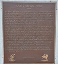 view gallery view galleryNW0.3 km |  First School in Goffs First School in Goffs
in First of its Kind The first school in Goffs opened its doors for the fall term in 1911. posted by: brwhiz location: California date approved: 11/10/2012 last visited: 12/18/2021 |
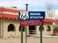
 view gallery view galleryNW0.5 km |  Historic Route 66 - Goffs Schoolhouse - Essex, California, USA Historic Route 66 - Goffs Schoolhouse - Essex, California, USA
in National Scenic Byways The first Schoolhouse in Goffs, was in use operation from 1914 to 1937. Restored in 1998, as a Museum and was added to the National Register of Historic Places in 2001. A roadside attraction located in the Ghost Town of Goffs, California. posted by: veritas vita location: California date approved: 12/14/2014 last visited: 12/23/2018 |
 view gallery view galleryNW0.5 km |  Goffs Schoolhouse Museum - Essex, California, USA. Goffs Schoolhouse Museum - Essex, California, USA.
in History Museums The first Schoolhouse in Goffs, was in use operation from 1914 to 1937. Restored in 1998, as a Museum and was added to the National Register of Historic Places in 2001. A roadside attraction located in the Ghost Town of Goffs, California. posted by: veritas vita location: California date approved: 02/13/2015 last visited: 12/18/2021 |
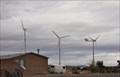 view gallery view gallery SW15.8 km SW15.8 km
| Three Windmills in Windmills These three windmills generate electrical power for a private residence near the junction of Goffs Road and Interstate Highway 40 in southeastern California. posted by: brwhiz location: California date approved: 09/24/2013 last visited: never |
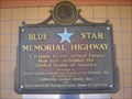 view gallery view gallerySW18.7 km |  John Wilkie Rest Area - Fenner, CA John Wilkie Rest Area - Fenner, CA
in Blue Star Memorial Highway Markers On Rest Room Wall posted by: beagle39z location: California date approved: 04/09/2009 last visited: 07/10/2018 |
 view gallery view gallerySW18.8 km |  John Wilkie - Fenner, CA John Wilkie - Fenner, CA
in Citizen Memorials A citizen memorial at a rest stop on I-40 eastbound in the Mojave Desert. posted by: bluesnote location: California date approved: 09/13/2024 last visited: never |
 view gallery view gallerySW18.8 km |  John Wilkie Safety Roadside Rest Area (Eastbound) - Fenner, CA John Wilkie Safety Roadside Rest Area (Eastbound) - Fenner, CA
in Highway Rest Areas A rest stop along I-40 eastbound in the Mojave Desert. posted by: bluesnote location: California date approved: 09/13/2024 last visited: never |
 view gallery view gallerySW18.8 km |  Camp Clipper - Fenner, CA Camp Clipper - Fenner, CA
in California Historical Markers Marker located at the John Wilkie Safety Rest Area on I-40 Eastbound posted by: Mountain_Wanderer location: California date approved: 10/22/2008 last visited: 05/24/2024 |
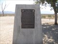 view gallery view gallerySW18.8 km | Clipper Divisional Camp - Fenner, CA in E Clampus Vitus Historical Markers Marker located at the John Wilkie Safety Rest Area on I-40 Eastbound posted by: Mountain_Wanderer location: California date approved: 10/22/2008 last visited: 05/24/2024 |
 view gallery view gallerySW18.8 km |  Camp Clipper - Fenner, CA Camp Clipper - Fenner, CA
in The Holocaust One of two historical markers at a rest area along I-40 eastbound in the Mojave Desert. posted by: bluesnote location: California date approved: 09/17/2024 last visited: never |
 view gallery view gallerySW18.8 km |  Camp Clipper - Fenner, CA Camp Clipper - Fenner, CA
in World War II Memorials / Monuments One of two historical markers at a rest area along I-40 eastbound in the Mojave Desert. posted by: bluesnote location: California date approved: 09/13/2024 last visited: never |
 view gallery view gallerySW18.8 km | Camp Clipper - Fenner, CA in World War II Sites One of two historical markers at a rest area along I-40 eastbound in the Mojave Desert. posted by: bluesnote location: California date approved: 09/14/2024 last visited: never |
 view gallery view gallery E19.3 km E19.3 km
| Burma Shave Signs - Route 66 - California, USA. in Route 66 - The Mother Road The Burma Shave signs were common sights on the highways & byways of America from 1925 to 1963. Many of these signs were evident as you travel along the 2,400 miles of Route 66 - These are modern replacements, this set near Bannock, California, USA. posted by: veritas vita location: California date approved: 09/28/2017 last visited: 11/03/2017 |
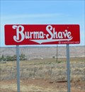 view gallery view galleryE19.3 km | Historic Route 66 - Burma Shave Signs - California, USA. in National Scenic Byways The Burma Shave signs were common sights on the scenic highways & byways of America from 1925 to 1963. Many of these signs were evident as you travel along the 2,400 miles of Route 66. These are modern replacements, this set near Bannock, California posted by: veritas vita location: California date approved: 09/29/2017 last visited: 11/03/2017 |
 view gallery view galleryE21.7 km | Camp Ibis in California Historical Markers An old army training center in the California desert. posted by: ggmorton location: California date approved: 10/03/2007 last visited: 11/06/2019 |
|