 view gallery view gallery W10 km W10 km
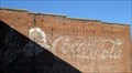
|   Santa/Coca-Cola Mural from White River Kid Santa/Coca-Cola Mural from White River Kid
in Murals This is a cool Santa/Coca-Cola mural that "Looks like a ghost" mural but isn't. It was painted by the crew that filmed the White River Kid. posted by:  trekkerz trekkerz location: Arkansas date approved: 01/26/2007 last visited: 03/13/2016 |
 view gallery view gallery NW15.1 km NW15.1 km
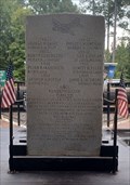
|  B-17 #229532 - Sheridan, AR B-17 #229532 - Sheridan, AR
in Arkansas Historical Markers This stone memorial was set in 1944 in honor of the crew of a downed B-17 Flying Fortress - north of Sheridan, Arkansas. posted by: The Snowdog location: Arkansas date approved: 09/25/2023 last visited: never |
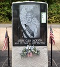 view gallery view galleryNW15.1 km |  Jerry Glen Jackson - Sheridan, AR Jerry Glen Jackson - Sheridan, AR
in Scouts Monuments and Memorials This memorial to Boy Scout Jerry Glen Jackson is in Veterans Memorial Park - north of Sheridan, Arkansas. posted by: The Snowdog location: Arkansas date approved: 09/25/2023 last visited: never |
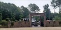 view gallery view galleryNW15.3 km |  Veterans Memorial Park - Sheridan, AR Veterans Memorial Park - Sheridan, AR
in Non-Specific Veteran Memorials Veterans Memorial Park is on the east side of Grant, about five miles north of Sheridan, Arkansas. posted by: The Snowdog location: Arkansas date approved: 09/29/2023 last visited: never |
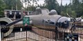 view gallery view galleryNW15.3 km |  B-17 Flying Fortress - Sheridan, AR B-17 Flying Fortress - Sheridan, AR
in Static Aircraft Displays This full-size replica of a B-17 Flying Fortress is the centerpiece of Veterans Memorial Park - north of Sheridan, Arkansas. posted by: The Snowdog location: Arkansas date approved: 09/26/2023 last visited: never |
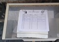 view gallery view galleryNW15.3 km |  Guest Book - Veterans Memorial Park - Sheridan, AR Guest Book - Veterans Memorial Park - Sheridan, AR
in Guest Books This guest book is just inside the entrance to Veterans Memorial Park - north of Sheridan, Arkansas. posted by: The Snowdog location: Arkansas date approved: 09/24/2023 last visited: never |
 view gallery view gallery E18.3 km E18.3 km
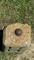
|  BM No. 14 - Pine Bluff Arsenal, AR BM No. 14 - Pine Bluff Arsenal, AR
in U.S. Benchmarks A local benchmark situated out front of the arsenal's medical clinic. posted by:  TheRadcliffs TheRadcliffs location: Arkansas date approved: 05/17/2016 last visited: 10/27/2016 |
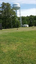 view gallery view galleryE18.5 km | EJ1774 (PINE BLUFF ARSENAL TANK 13000) - PBA, AR in U.S. Benchmarks Water tower located on Pine Bluff Arsenal behind the medical clinic. posted by: TheRadcliffs location: Arkansas date approved: 05/16/2016 last visited: 10/27/2016 |
 view gallery view gallery SW26.2 km SW26.2 km
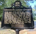
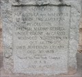
| Confederate Cannons Captured - Near Leola, AR in Arkansas Historical Markers Located in Jenkins Ferry Battlefield State Park near the picnic pavilion describes some of the events of the Battle of Jenkins Ferry. Marker erected as part of the Arkansas Civil War Sesquicentennial. posted by: hoteltwo location: Arkansas date approved: 08/17/2018 last visited: never |
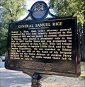 view gallery view gallerySW26.2 km | General Samuel Rice - Near Leola, AR in Arkansas Historical Markers Located NNE of Leola at Jenkins Ferry Battlefield State Park off AR-46. Marker notes the efforts of Union General Samuel Rice at the Battle of Jenkins Ferry and being wounded there. Marker erected as part of the Arkansas Civil War Sesquicentennial. posted by: hoteltwo location: Arkansas date approved: 08/17/2018 last visited: never |
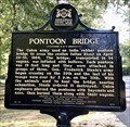 view gallery view gallerySW26.4 km | Pontoon Bridge - Near Leola, AR in Arkansas Historical Markers Located at Jenkins Ferry Battelefield State Park, off Highway 46. Describes the methods the Union army used to cross the Saline River during the Battle of Jenkins Ferry. Marker erected as part of the Arkansas Civil War Sesquicentennial. posted by: hoteltwo location: Arkansas date approved: 08/17/2018 last visited: never |
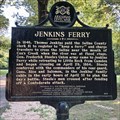 view gallery view gallerySW26.4 km | Jenkins Ferry - Near Leola, AR in Arkansas Historical Markers Located at Jenkins Ferry Battelefield State Park, off Highway 46, at the Saline River, notes the owner and operator of the river ferry used during the Battle of Jenkins Ferry. Marker erected as part of the Arkansas Civil War Sesquicentennial. posted by: hoteltwo location: Arkansas date approved: 08/17/2018 last visited: never |
 view gallery view gallery SE26.7 km SE26.7 km
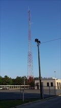
| EJ1798 (RADIO STA KKD 270) - Pine Bluff, AR in U.S. Benchmarks Radio tower in Pine Bluff Arkansas. posted by: TheRadcliffs location: Arkansas date approved: 05/16/2016 last visited: 11/04/2016 |
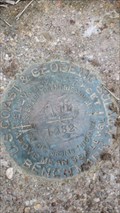 view gallery view gallerySE26.9 km | EJ0624 (C 11) - Pine Bluff, AR in U.S. Benchmarks Benchmark disk in Pine Bluff, AR. posted by: TheRadcliffs location: Arkansas date approved: 05/16/2016 last visited: never |
 view gallery view galleryE26.9 km |  Chief SARASEN Chief SARASEN
in Grave of a Famous Person “Friend of the Missionaries. Rescuer of captive children.” posted by: harrisonha location: Arkansas date approved: 04/18/2011 last visited: 08/09/2010 |
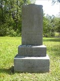
 view gallery view galleryE28.3 km |  Auguste la noir de Serville Auguste la noir de Serville
in American Revolutionary War Veteran Graves This marker raises a lot of questions, and we haven't been able to find many answers to them. posted by: the Tribe of Two location: Arkansas date approved: 05/10/2007 last visited: 12/10/2014 |
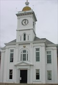 view gallery view galleryE28.3 km |  Courthouse Clock, Pine Bluff, AR Courthouse Clock, Pine Bluff, AR
in Town Clocks Visible for a long way along the Main Street of downtown Pine Bluff. posted by: the Tribe of Two location: Arkansas date approved: 05/02/2007 last visited: 01/16/2011 |
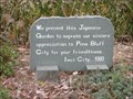 view gallery view galleryE28.8 km |  Iwai Garden - Pine Bluff, Arkansas Iwai Garden - Pine Bluff, Arkansas
in Japanese Gardens A charming courtyard garden located at Pine Bluff's Civic Center. posted by: the Tribe of Two location: Arkansas date approved: 02/01/2007 last visited: 11/05/2010 |
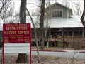 view gallery view galleryE29 km |  Governor Mike Huckabee Delta Rivers Nature Center - Pine Bluff, AR Governor Mike Huckabee Delta Rivers Nature Center - Pine Bluff, AR
in Nature Centers Open Tuesdays - Saturdays 8:30 a.m.-4:30 p.m. Open Sundays 1-5 and closed on Mondays. posted by: the Tribe of Two location: Arkansas date approved: 02/10/2007 last visited: 01/16/2011 |
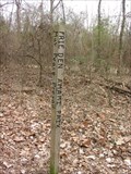 view gallery view galleryE29.1 km |  Peace Pole at Delta Rivers Nature Center, Pine Bluff, AR Peace Pole at Delta Rivers Nature Center, Pine Bluff, AR
in Peace Poles A peace pole greets hikers near Black Dog Bayou. posted by: the Tribe of Two location: Arkansas date approved: 02/10/2007 last visited: 01/16/2011 |
 view gallery view gallerySE29.1 km |  Bain, Jewel, House Number 2 - Pine Bluff, AR Bain, Jewel, House Number 2 - Pine Bluff, AR
in U.S. National Register of Historic Places An example of the Art Moderne style houses built in the 1920s and 30s. posted by: TheRadcliffs location: Arkansas date approved: 05/17/2016 last visited: 11/03/2016 |
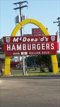 view gallery view gallerySE29.3 km | McDonald's Store #433 Sign - Pine Bluff, AR in U.S. National Register of Historic Places One of a very few single arch McDonald's signs still in use. posted by: TheRadcliffs location: Arkansas date approved: 05/17/2016 last visited: 10/02/2016 |
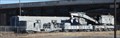 view gallery view galleryE29.9 km |  SSW (Cotton Belt) MOW Crane 96005 -- AR RR Museum Pine Bluff AR SSW (Cotton Belt) MOW Crane 96005 -- AR RR Museum Pine Bluff AR
in Railroad Maintenance-Of-Way Equipment This MASSIVE steam-powered relief crane is a historic piece of MOW equipment. It was deployed by the Cotton Belt Railroad to clear tracks and right cars that had derailed. posted by: Benchmark Blasterz location: Arkansas date approved: 09/13/2012 last visited: 01/09/2016 |
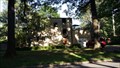
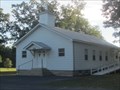 view gallery view galleryNW29.9 km |  Ebeneezer United Methodist Church, Tull, Arkansas Ebeneezer United Methodist Church, Tull, Arkansas
in Country Churches This old church has served families since before the Civil War. posted by: Queens Blessing location: Arkansas date approved: 01/04/2016 last visited: never |
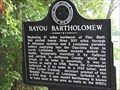 view gallery view gallerySE30.6 km | Bayou Bartholomew in Arkansas Historical Markers This marker stands on the east side of S. Olive St. at the intersection with Main Street in Pine Bluff. The bayou itself is south of the marker. posted by: QuesterMark location: Arkansas date approved: 01/21/2009 last visited: 04/26/2016 |
|