 view gallery view gallery S5.1 km S5.1 km
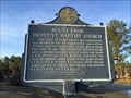
|   Mount Enon Primitive Baptist Church - Erwin, AL Mount Enon Primitive Baptist Church - Erwin, AL
in Alabama Historical Markers Marker is at the intersection of Henry County Roads 54, 75 and 68 and describes the beginnings of the early Mount Enon church. posted by:  hoteltwo hoteltwo location: Alabama date approved: 04/01/2014 last visited: 01/13/2022 |
 view gallery view gallery SE10.5 km SE10.5 km
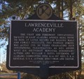
| Lawrenceville Academy - Lawrenceville, AL in Alabama Historical Markers Located at the intersection of Henry County Roads 119 & 37, this marker highlights one of the then top educational schools in Alabama and one of its graduates, Alabama Governor Oates. posted by: hoteltwo location: Alabama date approved: 04/01/2014 last visited: 05/17/2021 |
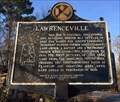 view gallery view gallerySE10.5 km | Lawrenceville - Lawrenceville, AL in Alabama Historical Markers This marker describes the early settlers of the former town of Lawrenceville and is located at the intersection of Henry County Roads 119 and 37. posted by: hoteltwo location: Alabama date approved: 04/01/2014 last visited: 05/17/2021 |
 view gallery view gallery SW13.2 km SW13.2 km
| Blue Springs School 1920-1969 - Blue Springs, AL in Alabama Historical Markers The Blue Springs School was first established in 1920. posted by:  hummerstation hummerstation location: Alabama date approved: 10/29/2012 last visited: 01/13/2022 |
 view gallery view gallery W14.5 km W14.5 km
| Pea River Electric Membership Corporation, Blue Springs, AL in Alabama Historical Markers A short history of the first electric service in this area posted by: OHail location: Alabama date approved: 05/19/2013 last visited: 01/13/2022 |
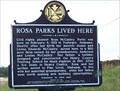 view gallery view gallerySE14.6 km | Rosa Parks Lived Here - Abbeville, AL in Alabama Historical Markers Shortly after her birth civil rights pioneer Rosa McCauley moved here to a 260 acre farm owned by her grandparents, Anderson and Louisa McCauley. posted by: hummerstation location: Alabama date approved: 10/29/2012 last visited: 05/17/2021 |
 view gallery view galleryW14.6 km |  Blue Springs Blue Springs
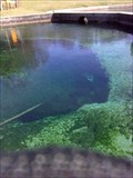
in Natural Sinkholes This pool with 68° degree clear blue water is formed from a spring fed sinkhole. It is located in Blue Springs State Park. posted by: strummin_along location: Alabama date approved: 11/24/2013 last visited: 01/13/2018 |
 view gallery view galleryW14.6 km |  Blue Springs Blue Springs
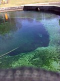
in Natural Springs This natural spring is located inside Blue Springs State Park. The park is open 7am to sundown, year round. The park's address is 2595 Highway 10, Clio, Al 36017-4875. posted by: strummin_along location: Alabama date approved: 11/23/2013 last visited: 01/13/2018 |
 view gallery view gallery N14.8 km N14.8 km
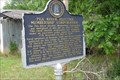
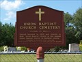
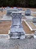
|  Union Baptist Church Cemetery - Clayton, AL Union Baptist Church Cemetery - Clayton, AL
in Worldwide Cemeteries Union Baptist Church is the second oldest Baptist church in Barbour County. posted by: hummerstation location: Alabama date approved: 11/16/2012 last visited: 01/13/2022 |
 view gallery view galleryN14.8 km | Union Baptist Church Cemetery - Clayton, AL in Alabama Historical Markers Union Baptist Church is the second oldest Baptist church in Barbour County. posted by: hummerstation location: Alabama date approved: 11/02/2012 last visited: 01/13/2022 |
 view gallery view galleryN14.8 km |  Union Baptist Church - Clayton, AL Union Baptist Church - Clayton, AL
in Baptist Churches Union Baptist Church is the second oldest Baptist church in Barbour County, AL. posted by: hummerstation location: Alabama date approved: 11/14/2012 last visited: 01/13/2022 |
 view gallery view gallery NE15.1 km NE15.1 km
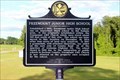
| Freemount Junior High School - Bakerhill. AL in Alabama Historical Markers Located on AL 131 at Dennis Road, Bakerhill posted by: Markerman62 location: Alabama date approved: 05/29/2021 last visited: never |
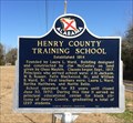 view gallery view galleryS15.4 km | Henry County Training School - Abbeville, AL in Alabama Historical Markers Located a few miles west of Abbeville this school was the main educational center for black students in Henry County. posted by: hoteltwo location: Alabama date approved: 03/06/2014 last visited: 05/14/2021 |
 view gallery view gallery E15.4 km E15.4 km
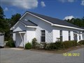
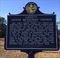
| Liberty United Methodist Church - Screamer, AL in Alabama Historical Markers Located on Henry County Road 92, just north of Alabama Highway 95, this marker denotes the history of the church. posted by: hoteltwo location: Alabama date approved: 04/01/2014 last visited: never |
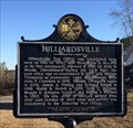 view gallery view galleryE15.4 km | Hilliardsville - Screamer, AL in Alabama Historical Markers Information on the beginnings of the Hilliardsville Post Office. Marker is located on Henry County Road 92, just north of Alabama Highway 95. posted by: hoteltwo location: Alabama date approved: 04/01/2014 last visited: never |
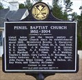 view gallery view gallerySW16.9 km | Peniel Baptist Church 1852 - 2004 - Skipperville, AL in Alabama Historical Markers Peniel Baptist Church was established about 1852. posted by: hummerstation location: Alabama date approved: 02/01/2014 last visited: 07/14/2022 |
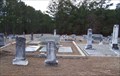 view gallery view gallerySW16.9 km | Peniel Baptist Church Cemetery - Skipperville, AL in Worldwide Cemeteries Peniel Baptist Church Cemetery is located across County Road 41 from Peniel Baptist Church. posted by: hummerstation location: Alabama date approved: 02/22/2014 last visited: never |
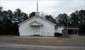 view gallery view gallerySW16.9 km | Peniel Baptist Church - Skipperville, AL in Baptist Churches Peniel Baptist Church is located at 2710 County Road 41, Skipperville, Alabama. posted by: hummerstation location: Alabama date approved: 03/13/2014 last visited: never |
 view gallery view gallerySW16.9 km |  Ralph G. Arnold - Peniel Cemetery - Skipperville, AL Ralph G. Arnold - Peniel Cemetery - Skipperville, AL
in Woodmen of the World Grave Markers/Monuments The Ralph G. Arnold Woodmen of the World marker is located in Peniel Cemetery across County Road from Peniel Baptist Church. posted by: hummerstation location: Alabama date approved: 02/19/2014 last visited: never |
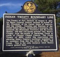 view gallery view galleryE16.9 km | Indian Treaty Boundary Line - Screamer, AL in Alabama Historical Markers One of a series of markers showing the boundary line between the Creek Indians and the Mississippi Territory. posted by: hoteltwo location: Alabama date approved: 04/01/2014 last visited: never |
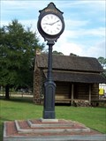 view gallery view gallerySE18.3 km |  Abbeville Clock - Abbeville, AL Abbeville Clock - Abbeville, AL
in Town Clocks Abbeville Clock, Abbeville, AL posted by: hummerstation location: Alabama date approved: 12/08/2012 last visited: 05/19/2013 |
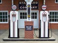 view gallery view gallerySE18.3 km |  Crown Gas Pumps - Abbeville, AL Crown Gas Pumps - Abbeville, AL
in Vintage Gasoline Pumps Old gas pumps outside the Old Standard Oil Filling Station. posted by: hummerstation location: Alabama date approved: 11/18/2012 last visited: 05/14/2021 |
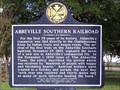 view gallery view gallerySE18.5 km | Abbeville Southern Railroad - Abbeville, AL in Alabama Historical Markers The Abbeville Southern Railroad brought a new era in Abbeville’s commercial life. posted by: hummerstation location: Alabama date approved: 10/29/2012 last visited: 05/14/2021 |
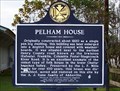 view gallery view gallerySE18.5 km | Pelham House - Abbeville, AL in Alabama Historical Markers Pelham House was originally constructed about 1820 as a single pen log dwelling. posted by: hummerstation location: Alabama date approved: 10/29/2012 last visited: 05/17/2021 |
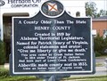 view gallery view gallerySE18.8 km | A County Older Than the State - Abbeville, AL in Alabama Historical Markers Henry County was created in 1819 by Alabama Territorial Legislature. posted by: hummerstation location: Alabama date approved: 10/29/2012 last visited: 05/14/2021 |
|