 view gallery view gallery SE5.8 km SE5.8 km
|   First Reinforced Concrete River Bridge in Alabama - Ariton, Alabama First Reinforced Concrete River Bridge in Alabama - Ariton, Alabama
in First of its Kind The bridge was bypassed by new bridges for U. S. Highway 231 about twelve miles north of Ozark, Alabama, but remains as a pedestrian bridge. posted by:  xptwo xptwo location: Alabama date approved: 03/08/2012 last visited: never |
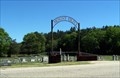
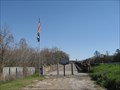 view gallery view gallerySE5.8 km |  Veterans Memorial Bridge - Ariton, Alabama Veterans Memorial Bridge - Ariton, Alabama
in Orphaned Bridges The bridge was bypassed by new bridges for U. S. Highway 231 about twelve miles north of Ozark, Alabama, but remains as a pedestrian bridge. posted by: xptwo location: Alabama date approved: 04/08/2012 last visited: never |
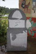
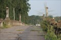 view gallery view gallerySE5.8 km |  Veteran's Memorial Bridge-Old Grist Mill Veteran's Memorial Bridge-Old Grist Mill
in Alabama Historical Markers Dual Sign showing location of a Grist Mill and the First Concrete Bridge in Alabama. posted by: de68ie location: Alabama date approved: 01/17/2009 last visited: 10/05/2015 |
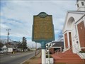 view gallery view gallery N8.2 km N8.2 km
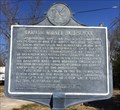
| Salem Baptist Church - Brundidge, AL in Alabama Historical Markers This marker is located outside Salem Baptist Church in Brundidge, Alabama. posted by: xptwo location: Alabama date approved: 01/22/2013 last visited: 10/05/2015 |
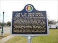 view gallery view galleryN8.4 km | Brundidge City Hall - Brundidge, AL in Alabama Historical Markers This marker is located in front of the Brundidge City Hall and tells the history of the building. posted by: xptwo location: Alabama date approved: 01/21/2013 last visited: 10/05/2015 |
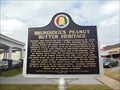 view gallery view galleryN8.4 km | Brundidge's Peanut Butter Heritage - Brundidge, AL in Alabama Historical Markers This marker is located in front of the Brundidge City Hall and tells the reason for the annual Peanut Butter Festival. posted by: xptwo location: Alabama date approved: 02/11/2013 last visited: 10/05/2015 |
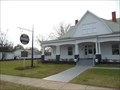 view gallery view galleryN8.4 km |  Brundidge, AL Brundidge, AL
in City and Town Halls The Brundidge City Hall is located in a historic residence that was renovated and converted to use by the city government. posted by: xptwo location: Alabama date approved: 06/14/2013 last visited: 02/16/2014 |
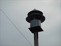 view gallery view galleryN8.5 km |  Tornado Siren - Brundidge, AL Tornado Siren - Brundidge, AL
in Outdoor Warning Sirens This siren is located in back of the police station in Brundidge, Alabama. posted by: xptwo location: Alabama date approved: 05/20/2013 last visited: never |
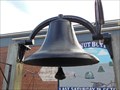 view gallery view galleryN8.5 km |  Park Bell - Brundidge, AL Park Bell - Brundidge, AL
in Bells This bell is displayed in a small urban park on North Main Street in Brundidge, Alabama. posted by: xptwo location: Alabama date approved: 05/10/2013 last visited: never |
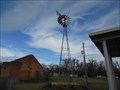 view gallery view galleryN8.7 km |  Brundidge Windmill - Brundidge, AL Brundidge Windmill - Brundidge, AL
in Windmills This windmill is located next to the old train depot building in downtown Brudidge, Alabama. posted by: xptwo location: Alabama date approved: 05/16/2013 last visited: never |
 view gallery view gallery NW8.9 km NW8.9 km
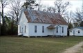
|  Union Springs Primitive Baptist Church - Troy, AL Union Springs Primitive Baptist Church - Troy, AL
in Baptist Churches Union Springs Primitive Baptist Church is located on Pike County Road 3316 south of Troy, AL. posted by: hummerstation location: Alabama date approved: 07/27/2015 last visited: never |
 view gallery view galleryN8.9 km |  Pike County High School Standpipe - Brundidge, AL Pike County High School Standpipe - Brundidge, AL
in Water Towers This water tank is located at a high point in Brundidge, Alabama, south of Troy. The area is listed as a park on the map. posted by: xptwo location: Alabama date approved: 05/31/2013 last visited: never |
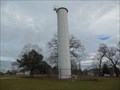 view gallery view galleryN8.9 km |  Pike County High School Standpipe (BT2173) - Brundidge, AL Pike County High School Standpipe (BT2173) - Brundidge, AL
in U.S. Benchmarks This water tank is located at a high point in Brundidge, Alabama, south of Troy. The area is listed as a park on the map. posted by: xptwo location: Alabama date approved: 05/11/2013 last visited: never |
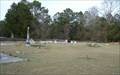 view gallery view galleryNW9 km |  Union Springs Primitive Baptist Church Cemetery - Troy, AL Union Springs Primitive Baptist Church Cemetery - Troy, AL
in Churchyard Cemeteries The Union Springs Primitive Baptist Church Cemetery is located on Pike County Road 3316 south of Troy, AL. posted by: hummerstation location: Alabama date approved: 07/27/2015 last visited: never |
 view gallery view galleryNW9 km |  Union Springs Primitive Baptist Church Cemetery - Troy, AL Union Springs Primitive Baptist Church Cemetery - Troy, AL
in Worldwide Cemeteries The Union Springs Primitive Baptist Church Cemetery is located on Pike County Road 3316 south of Troy, AL. posted by: hummerstation location: Alabama date approved: 07/27/2015 last visited: 07/18/2016 |
 view gallery view gallery S10.3 km S10.3 km
| Mt. Olive Cemetery - Rocky Head, AL in Worldwide Cemeteries Mt. Olive Cemetery is located on Alabama Highway 51. posted by: hummerstation location: Alabama date approved: 04/23/2017 last visited: never |
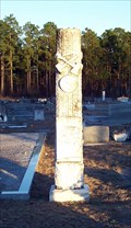
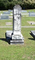 view gallery view galleryS10.3 km |  Walker Matthews - Mt. Olive Cemetery - Rocky Head, AL Walker Matthews - Mt. Olive Cemetery - Rocky Head, AL
in Woodmen of the World Grave Markers/Monuments The Walker Matthews Woodmen of the World Marker is located in Mt. Olive Cemetery, Rocky Head, AL. posted by: hummerstation location: Alabama date approved: 04/22/2017 last visited: never |
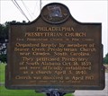 view gallery view galleryN10.5 km | Philadelphia Presbyterian Church - Brundidge, AL in Alabama Historical Markers Philadelphia Presbyterian Church was officially established as a church April 3, 1840. posted by: hummerstation location: Alabama date approved: 05/21/2013 last visited: 07/31/2022 |
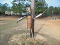 view gallery view galleryN11.6 km |  Muffler Man - Brundidge, AL Muffler Man - Brundidge, AL
in Car Part Sculptures This work of automotive art is located between Troy and Brundidge on U.S. Highway 231. posted by: xptwo location: Alabama date approved: 01/20/2013 last visited: 01/13/2018 |
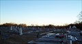 view gallery view galleryS16.7 km | Old Tabernacle Cemetery - New Brockton, AL in Worldwide Cemeteries Old Tabernacle Cemetery is located next to Old Tabernacle United Methodist Church. posted by: hummerstation location: Alabama date approved: 03/04/2014 last visited: never |
 view gallery view galleryS16.7 km | Preston C. Johnson - New Brockton, AL in Woodmen of the World Grave Markers/Monuments The Preston C. Johnson Woodmen of the World marker is located in the Old Tabernacle Cemetery on Highway 51. posted by: hummerstation location: Alabama date approved: 02/19/2014 last visited: never |
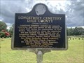 view gallery view galleryS17.7 km | Longstreet Cemetery - Dale County - Ozark, AL in Alabama Historical Markers Located on Marley Mill Road near County Road 233, Ozark posted by: Markerman62 location: Alabama date approved: 08/12/2022 last visited: never |
 view gallery view gallery E19.8 km E19.8 km
| Barbour County High School - Clio, AL in Alabama Historical Markers Marker explains the history of the Old Barbour County High School in Clio. Former Governor George C. Wallace was a graduate. posted by:  hoteltwo hoteltwo location: Alabama date approved: 03/06/2014 last visited: 01/13/2022 |
 view gallery view galleryE20.1 km |  Clio Heritage Mural, Starting Point of Barbour Co. Governor's Trail -- Clio AL Clio Heritage Mural, Starting Point of Barbour Co. Governor's Trail -- Clio AL
in Signs of History A monument at this mural of Governor George Wallace asking for white votes for Governor (black citizens could not vote in AL at the time through operation of Jim Crow) at the intersection of AL SH 10 and AL SH 51 in downtown Clio AL posted by: Benchmark Blasterz location: Alabama date approved: 09/07/2017 last visited: 07/28/2017 |
 view gallery view galleryE20.1 km | Clio Alabama Incorporated July 17, 1890 -- Clio AL in Signs of History Sign of history relating the circumstances of the incorporation of the city of Cleo in 1890 posted by: Benchmark Blasterz location: Alabama date approved: 09/07/2017 last visited: 07/28/2017 |
|