 view gallery view gallery NE7.9 km NE7.9 km
|   Titlum-Tatlum Titlum-Tatlum
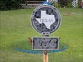
in Texas Historical Markers This marker is set in concrete a few feet from the parking lot near the San Luis Pass County Park office. posted by:  jhuoni jhuoni location: Texas date approved: 05/29/2019 last visited: never |
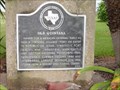
 view gallery view galleryNE7.9 km | Site of San Luis in Texas Historical Markers Located near the San Luis Pass County Park office, this marker tells of a coastal town that no longer exists. posted by: jhuoni location: Texas date approved: 05/29/2019 last visited: never |
 view gallery view gallery NW8 km NW8 km
|  Brazoria National Wildlife Refuge - Texas Brazoria National Wildlife Refuge - Texas
in National Wildlife Refuges A NWR in Brazoria County, Texas. posted by:  ggmorton ggmorton location: Texas date approved: 07/06/2007 last visited: 07/23/2010 |
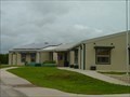 view gallery view galleryNW8 km |  Big Slough Recreation Area Discovery Center - Freeport, TX Big Slough Recreation Area Discovery Center - Freeport, TX
in Nature Centers A nature / discovery center at the Big Slough Recreation area of the Brazoria National Wildlife Refuge in Brazoria County, TX. posted by: ggmorton location: Texas date approved: 10/25/2020 last visited: 07/03/2007 |
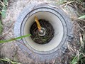
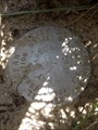
 view gallery view galleryNE8.2 km |  AW0119 - "Y 1237" vertical control mark - San Luis Pass, TX AW0119 - "Y 1237" vertical control mark - San Luis Pass, TX
in U.S. Benchmarks This benchmark is located on the SW side of the San Luis Pass toll bridge (right next to the the bridge's official plaque) on Brazoria County Rd 257 (Bluewater Hwy), in the small town of San Luis, Texas. posted by: Raven location: Texas date approved: 10/15/2017 last visited: 09/28/2017 |
 view gallery view galleryNE10.5 km | AW5710 - "HGCSD 61" metal rod - San Luis Pass, TX in U.S. Benchmarks This benchmark is located at the turnaround of the San Luis Pass toll bridge on FM-3005 (San Luis Pass Rd) just before the road becomes Brazoria County Rd 257 (Bluewater Hwy), .1mi NE of the toll booth, at the southern tip of Galveston Island, Texas. posted by: Raven location: Texas date approved: 10/15/2017 last visited: 04/29/2018 |
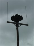 view gallery view galleryNW11.1 km |  Bastrop, TX Warning Siren Bastrop, TX Warning Siren
in Outdoor Warning Sirens A warning siren in the village of Bastrop, TX. posted by: ggmorton location: Texas date approved: 07/05/2007 last visited: 07/03/2007 |
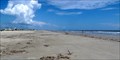 view gallery view galleryNE12.1 km |  Pointe West Beach - Galveston Island, TX Pointe West Beach - Galveston Island, TX
in Beaches Located close to the southern tip of Galveston Island, this beach offers no amenities but is the perfect spot to enjoy the sun, sea & sand while avoiding the usual crowded public beaches on this stretch of the Gulf. posted by: Raven location: Texas date approved: 10/22/2017 last visited: 06/24/2018 |
 view gallery view gallery W12.4 km W12.4 km
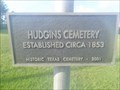
|  Hudgins Cemetery - Oyster Creek, TX Hudgins Cemetery - Oyster Creek, TX
in Worldwide Cemeteries Established in 1853 and designated a Texas Historic Cemetery in 2001, this is Hudgins or Hudgens Cemetery. posted by: jhuoni location: Texas date approved: 06/04/2019 last visited: 07/03/2007 |
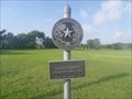 view gallery view galleryW12.4 km | Hudgins Cemetery in Texas Historical Markers Not to be confused with Hudgins Family Cemetery which is located near Hungerford in neighboring Wharton County. posted by: jhuoni location: Texas date approved: 06/05/2019 last visited: 07/03/2007 |
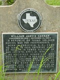 view gallery view galleryW12.4 km | William Jarvis Cannan in Texas Historical Markers A marker on the banks of Oyster Creek. posted by: ggmorton location: Texas date approved: 07/07/2007 last visited: 05/30/2019 |
 view gallery view gallery SW12.9 km SW12.9 km
|  Historical Jetties - Surfside Beach, TX Historical Jetties - Surfside Beach, TX
in Signs of History A historical time-line of the construction of the jetties at the seaport at Velasco, TX. posted by: jhuoni location: Texas date approved: 09/26/2016 last visited: 09/28/2017 |
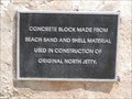 view gallery view gallerySW12.9 km | Original Jetty Concrete Block - Surfside, TX in Signs of History A block from the original jetty. posted by: jhuoni location: Texas date approved: 09/26/2016 last visited: 09/28/2017 |
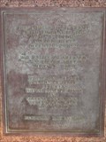
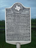 view gallery view gallerySW12.9 km | Old Velasco, C.S.A. in Texas Historical Markers A marker near the beach in Surfside. posted by: ggmorton location: Texas date approved: 07/07/2007 last visited: 09/28/2017 |
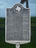 view gallery view gallerySW12.9 km | Gulf Intercoastal Waterway in Texas Historical Markers A marker near the beach in Surfside. posted by: ggmorton location: Texas date approved: 07/07/2007 last visited: 09/28/2017 |
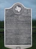 view gallery view gallerySW12.9 km | Velasco in Texas Historical Markers A marker near the beach in Surfside. posted by: ggmorton location: Texas date approved: 07/07/2007 last visited: 09/28/2017 |
 view gallery view gallerySW14.5 km |  Surfside City Hall Book Exchange - Surfside, TX Surfside City Hall Book Exchange - Surfside, TX
in Free Community Book Exchanges Located on the right side just before the steps leading up to the Surfside City Hall. posted by: jhuoni location: Texas date approved: 09/26/2016 last visited: never |
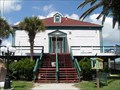 view gallery view gallerySW14.5 km |  Surfside, TX Surfside, TX
in City and Town Halls Located outside of Freeport, Surfside is a busy town. posted by: jhuoni location: Texas date approved: 09/26/2016 last visited: never |
 view gallery view gallerySW14.5 km | The Lively in Texas Historical Markers A marker near Surfside City Hall. posted by: ggmorton location: Texas date approved: 07/07/2007 last visited: 09/11/2016 |
 view gallery view gallerySW15.6 km | Allen Place in Texas Historical Markers An old boarding house in Quintana. posted by: ggmorton location: Texas date approved: 07/07/2007 last visited: 07/23/2008 |
 view gallery view gallerySW15.8 km | Old Quintana in Texas Historical Markers A marker about this old beach town, Quintana. posted by: ggmorton location: Texas date approved: 07/07/2007 last visited: 09/11/2016 |
 view gallery view galleryNE15.8 km | AW7024 - "BAY HARBOR" survey disk - Galveston Island, TX in U.S. Benchmarks This benchmark is located on the north side of FM-3005 (San Luis Pass Rd), at the road's NW intersection with 4th street (at Bay Harbor / West Beach), on Galveston Island, Texas. posted by: Raven location: Texas date approved: 10/15/2017 last visited: 09/28/2017 |
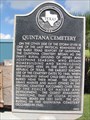 view gallery view gallerySW15.8 km | Quintana Cemetery in Texas Historical Markers This marker is located on the grounds of the Quintana Neotropical Bird Sanctuary. posted by: jhuoni location: Texas date approved: 09/28/2016 last visited: never |
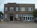 view gallery view gallerySW17.7 km |  Freeport National Bank - Freeport, TX Freeport National Bank - Freeport, TX
in Converted Bank Buildings The Freeport National Bank occupied this building from 1913-1955. posted by: ggmorton location: Texas date approved: 10/24/2020 last visited: 07/03/2007 |
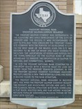 view gallery view gallerySW17.7 km | Freeport National Bank (Freeport Sulphur Company Building) in Texas Historical Markers A marker on what appears to be the old downtown area of Freeport. posted by: ggmorton location: Texas date approved: 07/07/2007 last visited: 07/18/2009 |
|