 view gallery view gallery W44.3 km W44.3 km
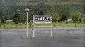
|   Otira, New Zealand Otira, New Zealand
in Train Stations/Depots Otira train station is a part of the Tranz Alpine track and is 'Otira' railway tunnel. posted by:  superstein superstein location: South Island, New Zealand date approved: 03/16/2015 last visited: never |
 view gallery view galleryW44.3 km |  Otira, New Zealand, 1239 feet Otira, New Zealand, 1239 feet
in Elevation Signs A elevation sign on Otira railwaystation. posted by: superstein location: South Island, New Zealand date approved: 03/15/2015 last visited: never |
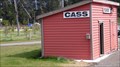 view gallery view gallery SW44.4 km SW44.4 km
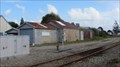
| Cass - New Zealand in Train Stations/Depots Small railwaystation on the trackline Christchurch - Graymouth. posted by: superstein location: South Island, New Zealand date approved: 03/28/2015 last visited: 09/06/2015 |
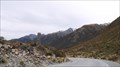 view gallery view gallerySW47.8 km |  Arthur Dudley Dobson - Arthers Pass - New Sealand Arthur Dudley Dobson - Arthers Pass - New Sealand
in Obelisks obelisks in memory of Athhur Dudley Dobson. posted by: superstein location: South Island, New Zealand date approved: 02/28/2021 last visited: never |
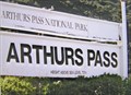
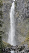 view gallery view gallerySW48.8 km |  devil's punchbowl waterfall, New zealand devil's punchbowl waterfall, New zealand
in Waterfalls One of the most impressive waterfalls in New Zealand, Devils Punchbowl Falls is located in the heart of Arthur's Pass National Park posted by: superstein location: South Island, New Zealand date approved: 01/12/2015 last visited: 11/20/2016 |
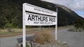 view gallery view gallerySW49.2 km | Arthur's Pass - New Zealand in Train Stations/Depots Arthur's Pass railway station is a part of the 'TranzAlpine' track between Christchurch and Greymouth posted by: superstein location: South Island, New Zealand date approved: 05/07/2015 last visited: 11/19/2016 |
 view gallery view gallerySW49.2 km | Arthurs Pass Station - 737metres. New Zealand. in Elevation Signs An elevation sign at the Arthurs Pass Railway Station platform, 737 metres above sealevel. posted by: Punga and Paua location: South Island, New Zealand date approved: 05/07/2009 last visited: 11/19/2016 |
 view gallery view gallery E64.7 km E64.7 km
|  The Hanmer Springs Gasometer, The Hanmer Springs Gasometer,
in Gasometers This gasometer was commisioned in 1898 and supplied gas to the sanitorium. It was decommisioned in 1940 when the town was connected to the national grid. posted by: greysman location: South Island, New Zealand date approved: 03/27/2011 last visited: 03/07/2013 |
 view gallery view gallery S69.8 km S69.8 km
| Springfield - New Zealand in Train Stations/Depots Springfield Station is a trainstation who was build in 1965. posted by: superstein location: South Island, New Zealand date approved: 02/17/2021 last visited: never |
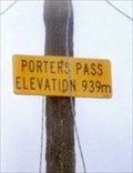 view gallery view gallerySW70.2 km | Porters Pass - 939m. South Is. New Zealand. in Elevation Signs An elevation sign on a telegraph pole at Porters Pass. posted by: Punga and Paua location: South Island, New Zealand date approved: 10/07/2009 last visited: 10/08/2009 |
 view gallery view galleryW77.2 km |  Mawhera Pa - Greymouth, New Zealand Mawhera Pa - Greymouth, New Zealand
in Maori Historic Sites The city of Greymouth, New Zealand, is built on the site of the ancient Mawhera Pa. It is marked with an information sign. posted by: Marine Biologist location: South Island, New Zealand date approved: 03/04/2020 last visited: never |
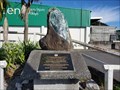
 view gallery view galleryW77.2 km |  Greenstone Monument - Greymouth, New Zealand Greenstone Monument - Greymouth, New Zealand
in Rock and Mineral Displays This piece of New Zealand greenstone (also called pounamu) is part of a monument marking the 150th anniversary of the purchase of Westland. posted by: Marine Biologist location: South Island, New Zealand date approved: 10/01/2020 last visited: never |
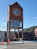 view gallery view galleryW77.4 km |  Old Post Office Clock - Greymouth, New Zealand Old Post Office Clock - Greymouth, New Zealand
in Lions Clubs International Markers The old clock is located along the seawall in Greymouth, New Zealand. posted by: Marine Biologist location: South Island, New Zealand date approved: 10/01/2020 last visited: never |
 view gallery view galleryW77.4 km |  Old Post Office Clock - Greymouth, New Zealand Old Post Office Clock - Greymouth, New Zealand
in Rotary International Markers The old clock is located along the seawall in Greymouth, New Zealand. posted by: Marine Biologist location: South Island, New Zealand date approved: 09/30/2020 last visited: 03/15/2024 |
 view gallery view galleryW77.4 km | Maori Settlement Commemoration Stone - Greymouth, New Zealand in Rock and Mineral Displays This piece of New Zealand greenstone (also called pounamu) is part of a commemoration of the Maori settlement of the area. posted by: Marine Biologist location: South Island, New Zealand date approved: 10/01/2020 last visited: never |
 view gallery view galleryW77.6 km |  Tribute Statue - Greymouth, New Zealand Tribute Statue - Greymouth, New Zealand
in Philatelic Photographs This fisherman tribute statue is located on the seawall in Greymouth, New Zealand. It was featured on a New Zealand postage stamp in 2009. posted by: Marine Biologist location: South Island, New Zealand date approved: 09/29/2020 last visited: never |
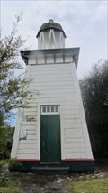 view gallery view galleryW90.3 km |  Hokatika lighthouse, New Zealand Hokatika lighthouse, New Zealand
in Coastal Lighthouses Lighthouse located on a hilltop above Fitzherbert Street (NZ 6) on the north side of Hokitika posted by: superstein location: New Zealand date approved: 02/14/2015 last visited: 12/27/2022 |
 view gallery view gallery NW90.8 km NW90.8 km
|  Punakaiki Resort - Punakaiki, New Zealand Punakaiki Resort - Punakaiki, New Zealand
in Recommended Accommodation Punakaiki Resort is located on New Zealand's wild West Coast at about 350m south of the famous Pancakes Rocks and Blowholes. posted by:  denben denben location: South Island, New Zealand date approved: 01/21/2015 last visited: 01/23/2015 |
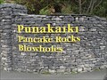 view gallery view galleryNW91.1 km |  Pancake Rocks & Blowholes - Dolomite Point - Punakaiki, New Zealand Pancake Rocks & Blowholes - Dolomite Point - Punakaiki, New Zealand
in Official Local Tourism Attractions The entrance to Pancake Rocks & Blowholes is located opposite the Paparoa National Park Visitors Centre at Dolomite Point, Punakaiki, West Coast. posted by: denben location: South Island, New Zealand date approved: 01/20/2015 last visited: 11/19/2016 |
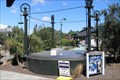
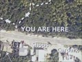 view gallery view galleryNW91.1 km |  You Are Here - Pancake Rocks & Blowholes - Punakaiki, New Zealand You Are Here - Pancake Rocks & Blowholes - Punakaiki, New Zealand
in 'You Are Here' Maps Map at the entrance to Pancake Rocks & Blowholes located opposite the Paparoa National Park Visitors Centre at Dolomite Point, Punakaiki, West Coast. posted by: denben location: South Island, New Zealand date approved: 01/21/2015 last visited: 03/15/2024 |
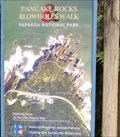 view gallery view galleryNW91.1 km |  Pancake Rocks & Blowholes Walk - Paparoa National Park - Punakaiki, New Zealand Pancake Rocks & Blowholes Walk - Paparoa National Park - Punakaiki, New Zealand
in Hiking and walking trailheads The Pancake Rocks & Blowholes Trailhead is located at the entrance to Pancake Rocks & Blowholes opposite the Paparoa National Park Visitors Centre at Dolomite Point, Punakaiki, West Coast. posted by: denben location: South Island, New Zealand date approved: 01/21/2015 last visited: 11/19/2016 |
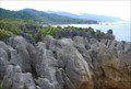 view gallery view galleryNW91.1 km |  Pancake Rocks. Punakaiki. West Coast. New Zealand. Pancake Rocks. Punakaiki. West Coast. New Zealand.
in Places of Geologic Significance The famous Pancake Rocks and Blowholes are just a 20 minute loop walk from where you park your vehicle on the main highway at Punakaiki on the West Coast of the South Island. posted by: Punga and Paua location: New Zealand date approved: 07/21/2008 last visited: 03/15/2024 |
 view gallery view galleryW91.4 km | Hokitika, New Zealand in Train Stations/Depots The Ross Branch, officially known as the Hokitika Line since 2011, and previously as the Hokitika Industrial Line, is a branch line railway that forms part of New Zealand's national rail network. posted by: superstein location: South Island, New Zealand date approved: 12/20/2014 last visited: 07/22/2015 |
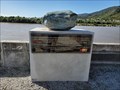
 view gallery view galleryNW91.4 km |  Paparoa National Park - Dolomite Point, Punakaiki, New Zealand Paparoa National Park - Dolomite Point, Punakaiki, New Zealand
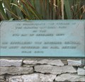
in Grand Opening The plaques (in English and Maori) are located along the Pancake Rocks and Blowholes walk within Paparoa National Park on the West Coast. posted by: denben location: South Island, New Zealand date approved: 01/22/2015 last visited: 03/15/2024 |
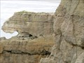 view gallery view galleryNW91.4 km |  Pancake Rocks Lion - Paparoa National Park - Punakaiki, New Zealand Pancake Rocks Lion - Paparoa National Park - Punakaiki, New Zealand
in Simulacra Pancake Rocks simulacra of a lion watching its prey in Paparoa National Park, Punakaiki. posted by: denben location: South Island, New Zealand date approved: 01/22/2015 last visited: 03/15/2024 |
|