 view gallery view gallery N0.5 km N0.5 km
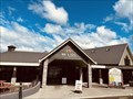
|   Wai-o-Tapu Welcome Centre - Waiotapu, New Zealand Wai-o-Tapu Welcome Centre - Waiotapu, New Zealand
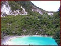
in Tourist Information Centers - Visitor Centers Thousands of years in the making and nestled within a natural bush setting, the Waiotapu Thermal Wonderland is home to a unique geothermal area. The Visitor Centre incorporates café and retail facilities. posted by:  giacaches giacaches location: North Island, New Zealand date approved: 03/10/2024 last visited: never |
 view gallery view gallery NW0.5 km NW0.5 km
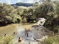
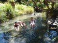
|  "Hot 'n' Cold" Hot Springs - Waiotapu, New Zealand "Hot 'n' Cold" Hot Springs - Waiotapu, New Zealand
in Hot Springs One of the most popular attractions in Waiotapu is the Hot 'n' Cold streams, also known as the Waiotapu Bridge hot springs. This natural wonder is a place to unwind and relax, and the best part is that visitors don't have to pay a cent to enjoy it. posted by: giacaches location: North Island, New Zealand date approved: 03/13/2024 last visited: 03/07/2024 |
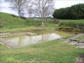
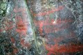
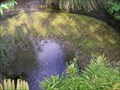
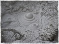 view gallery view galleryN1.9 km |  Waiotapu Mud Pool. Waiotapu. North Is. New Zealand. Waiotapu Mud Pool. Waiotapu. North Is. New Zealand.
in Places of Geologic Significance Here is an opportunity to visit an active Mud Pool, steaming, boiling and bubbling, beside the Loop Road at Waiotapu. posted by: Punga and Paua location: North Island, New Zealand date approved: 08/03/2015 last visited: 08/03/2015 |
 view gallery view gallery NE3.1 km NE3.1 km
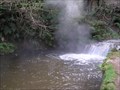
| Kerosine Creek. Waiotapu . North Is. New Zealand. in Hot Springs Kerosine Creek, a thermal hot spring and stream running through the geothermal area north of Waiotapu. posted by: Punga and Paua location: North Island, New Zealand date approved: 08/06/2015 last visited: 08/06/2015 |
 view gallery view galleryN4.5 km | Rainbow Mountain near Waiotapu. North Is. New Zealand. in Places of Geologic Significance Rainbow Mountain's Maori name is Maungakakaramea, meaning 'mountain of coloured earth'. This mountain lies in an active geothermal area south of Rotorua. posted by: Punga and Paua location: North Island, New Zealand date approved: 08/06/2015 last visited: 08/06/2015 |
 view gallery view gallery S10.8 km S10.8 km
| Butchers Pool. Reporoa. New Zealand. in Hot Springs This free hot water mineral pool is located 1.8 kilometers south of Reporoa on Broadlands Road, entrance is signposted from Broadlands Road.
Keep your head above water at all times to avoid the risk of contracting amoebic meningitis. posted by: Punga and Paua location: North Island, New Zealand date approved: 06/07/2010 last visited: 06/07/2010 |
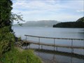
 view gallery view galleryNE14 km | Hot Water Beach - Lake Tarawera, Bay of Plenty, New Zealand in Hot Springs Hot Water Beach is the outlet of a (very) hot natural spring on the south shore of Lake Tarawera. A boat is required to get to the springs although work is being done to complete a tramping track along the lake's south coast. posted by: Trail Blaisers location: North Island, New Zealand date approved: 03/14/2013 last visited: never |
 view gallery view galleryN14.2 km | Wairua Stream Hot Pools -- Lake Tarawera, Bay of Plenty, New Zealand in Hot Springs Only the locals know about this secluded hot pool. Don't tell anyone else. Park your boat at S38 14.385 E176 25.495 and take a two minute walk on the well beaten path. posted by: Trail Blaisers location: North Island, New Zealand date approved: 03/14/2013 last visited: never |
 view gallery view gallery W14.2 km W14.2 km
|  Te Kopia Thermal Lookout, Te Kopia, Waikite Valley. North Is. New Zealand. Te Kopia Thermal Lookout, Te Kopia, Waikite Valley. North Is. New Zealand.
in Scenic Overlooks A Lookout platform provides an opportunity to view the Te Kopia Geothermal fields, with steaming vents and bubbling mudpools. posted by: Punga and Paua location: North Island, New Zealand date approved: 11/07/2018 last visited: 11/07/2018 |
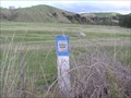 view gallery view galleryNE14.8 km |  Bench Mark AD71. Ash Pit Road. North Is. New Zealand. Bench Mark AD71. Ash Pit Road. North Is. New Zealand.
in Australia/NZ Benchmarks A bench mark on Ash Pit Road around Lake Rerewhakaaitu, near Mt.Tarawera. posted by: Punga and Paua location: North Island, New Zealand date approved: 05/18/2010 last visited: 05/16/2010 |
 view gallery view gallery SW16.3 km SW16.3 km
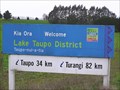
|  Welcome to Lake Taupo District. North Island. New Zealand. Welcome to Lake Taupo District. North Island. New Zealand.
in Welcome Signs The Lake Taupo District surrounds New Zealand's largest lake, Lake Taupo, in the centre of the North Island. posted by: Punga and Paua location: New Zealand date approved: 07/28/2008 last visited: 07/26/2008 |
 view gallery view galleryN16.4 km |  Te Wairoa; a Maori buried village; New Zealand Te Wairoa; a Maori buried village; New Zealand
in Maori Historic Sites Buried by volcanic activity in 1886 and partially excavated. Self guided tours take you inside some of the buildings. posted by: CoinsAndPins location: North Island, New Zealand date approved: 01/26/2007 last visited: 03/26/2015 |
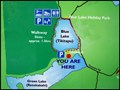
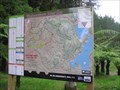
 view gallery view galleryN16.7 km |  You Are Here Map - Lake Tarawera Lookout, Bay of Plenty, New Zealand You Are Here Map - Lake Tarawera Lookout, Bay of Plenty, New Zealand
in 'You Are Here' Maps A "You Are Here" map at a nice roadside lookout over Lake Tarawera. There is an earthcache also located at the site (GC19AY2). posted by: Trail Blaisers location: North Island, New Zealand date approved: 03/12/2013 last visited: 03/12/2013 |
 view gallery view galleryN16.9 km |  Tarawera Phantom Canoe. Lake Tarawera. New Zealand. Tarawera Phantom Canoe. Lake Tarawera. New Zealand.
in Urban Legends and Superstitions Eleven days before the great eruption of Mt Tarawera in June 1886, a phantom Maori war canoe was seen to be sailing across the waters of Lake Tarawera. posted by: Punga and Paua location: North Island, New Zealand date approved: 07/27/2009 last visited: 02/13/2009 |
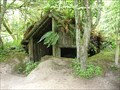
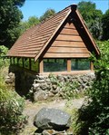
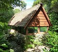
 view gallery view galleryN17.1 km |  Maori Rock Art. Lake Tarawera. New Zealand. Maori Rock Art. Lake Tarawera. New Zealand.
in Pictographs Tuhourangi Te Iwi (the tribe) of Lake Tarawera presents their treasured Maori Rock Art.
These precious ancient Maori Rock paintings have been protected by a grilled shelter near the wharf at the western side of Lake Tarawera near Rotorua. posted by: Punga and Paua location: North Island, New Zealand date approved: 06/18/2009 last visited: 03/20/2009 |
 view gallery view galleryN17.7 km | You Are Here - Green and Blue Lakes, Rotorua. North Is. New Zealand. in 'You Are Here' Maps You Are Here at the Blue and Green Lake Lookout. The sign says "Haere Mai" Welcome to the Lookout. You are standing on a narrow ridge between two lakes, one is blue and the other is green, Lake Tikitapu and Lake Rotokakahi. posted by: Punga and Paua location: North Island, New Zealand date approved: 04/18/2016 last visited: 03/06/2024 |
 view gallery view galleryN18 km | Urupa (Maori Burial Ground) and Mausoleum - Punaromia, Bay of Plenty, New Zealand in Maori Historic Sites This urupa (Maori burial ground) and mausoleum is in a small forest on the shores of Lake Tarawera. Go to a trailhead at S38 11.842 E176 23.669 and follow the somewhat faint white tree markings that lead you up the hill to the site. posted by: Trail Blaisers location: North Island, New Zealand date approved: 03/14/2013 last visited: 03/15/2013 |
 view gallery view galleryN18 km |  Spencer Mausoleum, Rotorua, New Zealand Spencer Mausoleum, Rotorua, New Zealand
in Mausoleums A surprising find tucked away in bushland. posted by: Tealby location: North Island, New Zealand date approved: 05/10/2009 last visited: 01/28/2013 |
 view gallery view galleryNW20 km |  Pukeko Mailbox. Whirinaki Valley Road. New Zealand. Pukeko Mailbox. Whirinaki Valley Road. New Zealand.
in Themed Homemade Mailboxes A unique Pukeko mailbox at a farm gate on the side of the road in the countryside south of Rotorua. posted by: Punga and Paua location: North Island, New Zealand date approved: 04/21/2011 last visited: 04/20/2011 |
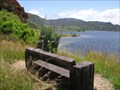 view gallery view galleryN20.1 km |  Mary Josephine Madsen - Lake Okareka Walkway. New Zealand. Mary Josephine Madsen - Lake Okareka Walkway. New Zealand.
in Dedicated Benches A chunky wooden seat at a beautiful view point along the Lake Okareka Walkway is dedicated to Mary Josephine Madsen for her long services to the Lake Okareka community. posted by: Punga and Paua location: North Island, New Zealand date approved: 02/25/2010 last visited: 02/25/2010 |
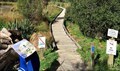 view gallery view galleryN20.1 km |  Lake Okareka Boardwalk, Rotorua, North Is. New Zealand. Lake Okareka Boardwalk, Rotorua, North Is. New Zealand.
in Non-Coastal Boardwalks Take a stroll along the shoreline of beautiful Lake Okareka and you can experience crossing a wetland by means of a timber boardwalk. posted by: Punga and Paua location: North Island, New Zealand date approved: 04/07/2019 last visited: 04/07/2019 |
 view gallery view galleryN20.1 km |  Waipa Spring. Rotorua. New Zealand. Waipa Spring. Rotorua. New Zealand.
in Natural Springs Situated within the Whakarewarewa Forest, the Waipa Spring provides water to the eastern parts of Rotorua City. posted by: Punga and Paua location: North Island, New Zealand date approved: 02/05/2012 last visited: 02/06/2012 |
 view gallery view galleryN20.8 km |  S 38 09' 37.18"/ E176 16' 05.67", Whakarewarewa Forest. Rotorua. New Zealand. S 38 09' 37.18"/ E176 16' 05.67", Whakarewarewa Forest. Rotorua. New Zealand.
in Permanent Geographic Coordinates Geographic coordinates S38 09' 37.18" E176 16' 05.67" are posted on the Forest Trail Map #8 located in Eight Mile Road in Whakarewarewa Forest. posted by: Punga and Paua location: North Island, New Zealand date approved: 03/13/2013 last visited: 03/13/2013 |
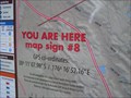 view gallery view galleryN20.8 km | You Are Here...Whakarewarewa Forest No.8 Map, Rotorua. New Zealand. in 'You Are Here' Maps You Are Here...walking or cycling through the Whakarewarewa Forest and you have stopped to look at the Forest Map No.8 near the parking area on Eight Mile Road. posted by: Punga and Paua location: North Island, New Zealand date approved: 02/24/2012 last visited: 02/24/2012 |
 view gallery view gallerySW21.2 km | Soaking In Paradise. Waikato. New Zealand. in Hot Springs Local thermal activity has produced these natural hot thermal springs hidden in a secret wilderness area known as Paradise along the banks of the Waikato River. posted by: Punga and Paua location: North Island, New Zealand date approved: 04/28/2008 last visited: 03/24/2008 |
|