 view gallery view gallery NE9.3 km NE9.3 km
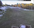
|   Dinner Plain Snow Cam Dinner Plain Snow Cam
in Web Cameras The Dinner Plain snow cam is located a short distance from Mount Hotham ski resort (Hotham Heights) posted by:  379Jonti379 379Jonti379 location: Victoria, Australia date approved: 06/04/2009 last visited: 05/16/2016 |
 view gallery view gallery N9.3 km N9.3 km
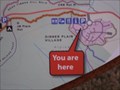
|  Brabralung Trail - You Are Here - Dinner Plain Village, Vic, Australia Brabralung Trail - You Are Here - Dinner Plain Village, Vic, Australia
in 'You Are Here' Maps This sign and map is a little distance away from where the trail actually starts, but shows the street layout, so it easy to find your way there. posted by: Grahame Cookie location: Victoria, Australia date approved: 11/03/2017 last visited: never |
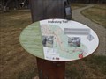 view gallery view galleryN9.3 km |  Brabralung Trail - Dinner Plain, Victoria, Australia Brabralung Trail - Dinner Plain, Victoria, Australia
in Hiking and walking trailheads This trail follows the ridge line, and roughly parallel to the Great Alpine Road. posted by: Grahame Cookie location: Victoria, Australia date approved: 11/06/2017 last visited: never |
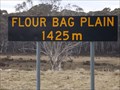 view gallery view galleryNE10.9 km |  Flour Bag Plain - Dinner Plain, Victoria - 1425 metres Flour Bag Plain - Dinner Plain, Victoria - 1425 metres
in Elevation Signs On the Great Alpine Road to Dinner Plain and Mount Hotham is the sign for Flour Bag Plain - 1425 m. posted by: Grahame Cookie location: Victoria, Australia date approved: 11/03/2017 last visited: never |
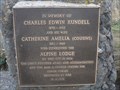 view gallery view galleryNE10.9 km |  Charles & Catherine Rundell - Dinner Plain, Vic, Australia Charles & Catherine Rundell - Dinner Plain, Vic, Australia
in Citizen Memorials Charles Edwin Rundell, and his wife are commemorated here by a bronze plaque on the side of the Great Alpine Road. posted by: Grahame Cookie location: Victoria, Australia date approved: 11/03/2017 last visited: never |
 view gallery view galleryN12.1 km |  Alex's Chalet - Mount Hotham, Victoria Alex's Chalet - Mount Hotham, Victoria
in Wee Folk Fairy Doors A small home for the wee folk posted by: bucketeer location: Victoria, Australia date approved: 12/29/2015 last visited: 05/17/2016 |
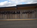 view gallery view galleryNE13.4 km |  Hotham Airport - Cobungra, Victoria, Australia Hotham Airport - Cobungra, Victoria, Australia
in Airports This high-altitude private airport services the local ski field of Mount Hotham by charter flights from Melbourne, and even Bankstown, Sydney (NSW). posted by: Grahame Cookie location: Victoria, Australia date approved: 11/03/2017 last visited: never |
![Image for Mount Hotham Airport [Mt Hotham, Vic, Australia]](https://img.geocaching.com/waymarking/small/6787b8bf-f311-47dd-9a68-c422775a14e1.jpg) view gallery view galleryNE13.4 km |  Mount Hotham Airport [Mt Hotham, Vic, Australia] Mount Hotham Airport [Mt Hotham, Vic, Australia]
in Wikipedia Entries This is a small regional airport in the Victorian alpine region. It services the nearby ski field and resort of Mount Hotham. posted by: Grahame Cookie location: Victoria, Australia date approved: 11/03/2017 last visited: never |
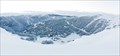
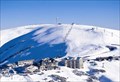 view gallery view galleryN14.2 km |  Mount Hotham Mount Hotham
in Winter Sports Locations Mount Hotham is a one of a kind ski resort, the village sits atop the resorts runs and lift systyms where as at any other resort the village is at the bottom. posted by: 379Jonti379 location: Victoria, Australia date approved: 05/30/2009 last visited: 06/22/2019 |
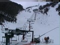 view gallery view galleryN14.5 km |  Heavenly Valley Quad Lift Heavenly Valley Quad Lift
in Aerial Lifts The Heavenly Valley Quad Lift is the longes ski lift at the
Mount Hotham ski resort. posted by: 379Jonti379 location: Victoria, Australia date approved: 06/14/2009 last visited: never |
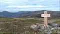 view gallery view gallery NW15.1 km NW15.1 km
|  The Cross - Great Alpine Road - Mt Hotham, Victoria The Cross - Great Alpine Road - Mt Hotham, Victoria
in Scenic Roadside Look-Outs At 1825 metres this in the highest point of The Great Alpine Road extends 339km between Wangaratta in Victoria’s North East to Metung on the Gippsland Lakes posted by: bucketeer location: Victoria, Australia date approved: 01/05/2017 last visited: never |
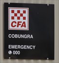 view gallery view gallery E17.4 km E17.4 km
|  CFA Cobungra CFA Cobungra
in Firehouses The local volunteer fire brigade of Cobrunga has a utilitarian Colorbond shed. posted by: Grahame Cookie location: Victoria, Australia date approved: 11/02/2017 last visited: never |
 view gallery view galleryN23.2 km |  Federation Hut Federation Hut
in Remote Backcountry Shelters Federation Hut is the main shelter on Mount Feathertop. posted by: 379Jonti379 location: Victoria, Australia date approved: 06/17/2009 last visited: 06/27/2019 |
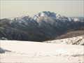 view gallery view galleryN23.5 km |  Mount Feathertop Mount Feathertop
in Mountain Summits Head to the summit of Mount Feathertop 1922 meters above sea level. Making it the 2nd highest mountain in Victoria!!! Its summit can be seen from all high points in the great dividing range and it is easy to recignize due to its unusual shaped peak. posted by: 379Jonti379 location: Victoria, Australia date approved: 05/27/2009 last visited: 06/25/2019 |
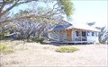
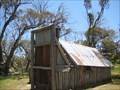 view gallery view galleryNE24.6 km | Wallace Hut - Alpine National Park - Victoria in Remote Backcountry Shelters Built in 1889 by the Wallace brothers (Arthur, William and Stewart), this hut is one of the oldest mountain huts in the Alpine National Park. posted by: bucketeer location: Victoria, Australia date approved: 04/19/2017 last visited: never |
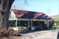 view gallery view galleryNW26.1 km |  Harrietville CPA, Vic, 3741 Harrietville CPA, Vic, 3741
in Australia Post Offices A CPA in the Victorian Alps foothills posted by: blingg location: Victoria, Australia date approved: 07/23/2018 last visited: never |
 view gallery view galleryN26.9 km | Falls Creek in Winter Sports Locations Falls creek is a ski resort located in the Victorian Alps. posted by: 379Jonti379 location: Victoria, Australia date approved: 05/30/2009 last visited: 12/17/2015 |
 view gallery view galleryN27.4 km | Falls Creek LPO, Vic, 3699 in Australia Post Offices One of the highest elevation post offices in Victoria posted by: blingg location: Victoria, Australia date approved: 10/20/2019 last visited: never |
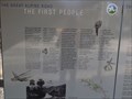 view gallery view galleryE29.8 km |  The First People - Mt Kosciuszko L/O, Vic, Australia The First People - Mt Kosciuszko L/O, Vic, Australia
in Australian Historical Markers At the 'Mt Kosciuszko' Lookout on the Great Alpine Road is an Interpretative Sign that talks about the first immigrant inhabitants to Australia; and describes how the Australian Alps could have been formed. posted by: Grahame Cookie location: Victoria, Australia date approved: 11/23/2017 last visited: never |
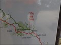 view gallery view galleryE29.8 km | Mt Kosciuszko Lookout - Great Alpine Road - URHere - Victoria in 'You Are Here' Maps Under a large shelter is an information sign, with a map of the Great Alpine Road, showing where You Are. posted by: Grahame Cookie location: Victoria, Australia date approved: 11/03/2017 last visited: never |
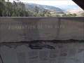 view gallery view galleryE29.8 km |  Formation of the Alps - Great Alpine Road, Vic, Australia Formation of the Alps - Great Alpine Road, Vic, Australia
in Orientation Tables At the 'Mt Kosciuszko' Lookout on the Great Alpine Road is an Interpretative Sign that shows a representation of how the Australian Alps could have been formed. posted by: Grahame Cookie location: Victoria, Australia date approved: 11/03/2017 last visited: never |
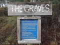 view gallery view galleryN37.2 km |  'The Graves' - Freeburgh Cemetery - Harrietville, Vic, Australia 'The Graves' - Freeburgh Cemetery - Harrietville, Vic, Australia
in Abandoned Cemeteries On the Great Alpine Road, between Freeburgh and Harrietville are a few graves up a forested hillside. posted by: Grahame Cookie location: Victoria, Australia date approved: 11/06/2017 last visited: never |
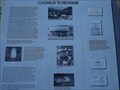 view gallery view galleryE38.8 km | Cassilis Township - Cassilis Road, Cassilis, Victoria in Australian Historical Markers This angled sign is on the corner of Salvia Drive and Cassilis Road, and gives the history of the immediate area. posted by: Grahame Cookie location: Victoria, Australia date approved: 11/02/2017 last visited: never |
 view gallery view galleryN39.8 km | Mount Beauty LPO, Vic, 3699 in Australia Post Offices An LPO in a town at the foot of the snowfields posted by: blingg location: Victoria, Australia date approved: 07/28/2018 last visited: never |
 view gallery view galleryN40.6 km | Tawonga South LPO, Vic, 3698 in Australia Post Offices An LPO in the Kiewa Valley posted by: blingg location: Victoria, Australia date approved: 07/28/2018 last visited: never |
|