 view gallery view gallery NE2.9 km NE2.9 km
|   Pie in the Sky, Cowan, NSW, Australia Pie in the Sky, Cowan, NSW, Australia
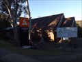
in Landlocked Boats Pie in the Sky, Cowan, NSW, Australia posted by:  Pensive Travellers Pensive Travellers location: New South Wales, Australia date approved: 01/25/2009 last visited: 07/31/2016 |
 view gallery view galleryNE2.9 km |  Pie in the Sky, Cowan, NSW, Australia Pie in the Sky, Cowan, NSW, Australia
in Independent Bakeries Pie in the Sky, Cowan, NSW, Australia posted by: Pensive Travellers location: New South Wales, Australia date approved: 12/21/2008 last visited: 07/31/2016 |
 view gallery view galleryNE2.9 km |  Pie in the Sky, Cowan, NSW, Australia Pie in the Sky, Cowan, NSW, Australia
in Independent Coffee Shops Pie in the Sky, Cowan, NSW, Australia posted by: Pensive Travellers location: New South Wales, Australia date approved: 12/22/2008 last visited: 07/31/2016 |
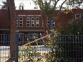 view gallery view gallery SW3.9 km SW3.9 km
|  Berowra Baptist Church - Berowra, NSW, Australia Berowra Baptist Church - Berowra, NSW, Australia
in Baptist Churches This brick building in Berowra, on the way to Berowra Waters, looks like it is a school. posted by:  Grahame Cookie Grahame Cookie location: New South Wales, Australia date approved: 01/14/2018 last visited: never |
 view gallery view gallerySW4 km |  Berowra LPO, NSW - 2081 Berowra LPO, NSW - 2081
in Australia Post Offices A 'boxy' red-brick building on Berowra Waters Road, very close to the Pacific Highway posted by: Grahame Cookie location: New South Wales, Australia date approved: 01/14/2018 last visited: never |
 view gallery view gallery W4 km W4 km
|  Great North Walk - Berowra, NSW, Australia Great North Walk - Berowra, NSW, Australia
in Long Distance Hiking Trails While the local track is called the Benowie Track, it is a part of the Great North Walk, from Circular Quay, in Sydney, to Newcastle, with this entry point at Berowra Waters. posted by: Grahame Cookie location: New South Wales, Australia date approved: 01/15/2018 last visited: never |
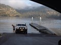
 view gallery view galleryW4.2 km |  Berowra Waters Ferry, NSW. Australia. Berowra Waters Ferry, NSW. Australia.
in Ferries and Ferry Landings The Berowra Waters Ferry is a cable ferry across the Berowra Creek, a tributary of the Hawkesbury River. posted by: Punga and Paua location: New South Wales, Australia date approved: 02/01/2013 last visited: 03/11/2017 |
 view gallery view gallerySW4.7 km |  Barnetts Reserve, Berowra, NSW, Australia Barnetts Reserve, Berowra, NSW, Australia
in Public Playgrounds Almost overlooking the Berowra Valley National Park, this modest sized Playground will keep the 'littlies' occupied. posted by: Grahame Cookie location: New South Wales, Australia date approved: 01/15/2018 last visited: never |
 view gallery view gallerySW4.7 km |  Barnetts Road Reserve Barnetts Road Reserve
in Scenic Overlooks Looks out over the Berowra regional park, includes good water views. posted by: GO Team K. location: New South Wales, Australia date approved: 06/23/2007 last visited: 12/04/2016 |
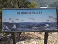 view gallery view gallerySW4.7 km |  Berowra Valley - Berowra, NSW, Australia Berowra Valley - Berowra, NSW, Australia
in Orientation Tables At the Barnetts Road Reserve section of the Berowra Valley National Park is a Lookout, with a great view of the Berowra Valley. There is an Orientation Table to show various localities. posted by: Grahame Cookie location: New South Wales, Australia date approved: 01/14/2018 last visited: never |
 view gallery view galleryNE6.3 km |  Hawkesbury River Bridge, Mooney, NSW, Australia Hawkesbury River Bridge, Mooney, NSW, Australia
in Truss Bridges Hawkesbury River Bridge, Mooney, NSW, Australia. posted by: Pensive Travellers location: New South Wales, Australia date approved: 06/21/2008 last visited: 02/16/2016 |
 view gallery view galleryNE6.8 km |  F3 Freeway, Mooney Mooney, NSW, Australia F3 Freeway, Mooney Mooney, NSW, Australia
in Web Cameras F3 Freeway Traffic Camera, Mooney Mooney, NSW, Australia posted by: Pensive Travellers location: New South Wales, Australia date approved: 06/25/2008 last visited: 03/08/2017 |
 view gallery view galleryNE6.8 km |  Mooney Mooney Boat Ramp, NSW, Australia Mooney Mooney Boat Ramp, NSW, Australia
in Boat Ramps This is a very busy boat ramp, as it is more accessible than heading into Brooklyn. posted by: Grahame Cookie location: New South Wales, Australia date approved: 10/09/2017 last visited: never |
 view gallery view galleryNE6.8 km |  Hawkesbury River Rest Area - Mooney Mooney, NSW, Australia Hawkesbury River Rest Area - Mooney Mooney, NSW, Australia
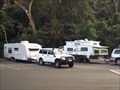
in Free Overnight RV Parking Locations With good access, while heading south or north on the Pacific Motorway, this is a good place to pull your van over. posted by: Grahame Cookie location: New South Wales, Australia date approved: 03/09/2018 last visited: never |
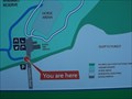
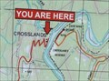 view gallery view gallerySW6.9 km |  UR Here - Crosslands Youth and Convention Centre, NSW, Australia UR Here - Crosslands Youth and Convention Centre, NSW, Australia
in 'You Are Here' Maps On the western side of Berowra Creek is the privately owned Crosslands Youth and Convention Centre. The map shows the lay of the land for the Berowra Valley.
You could park your car at the boom gate, and walk on down to take a photo of the map. posted by: Grahame Cookie location: New South Wales, Australia date approved: 01/29/2016 last visited: never |
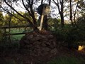
 view gallery view gallery S8 km S8 km
|  White 'mini trig', Terrey Hills, NSW White 'mini trig', Terrey Hills, NSW
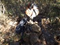
in Australian Trig Points Part of the original White trig mast is still here in the Ku-Ring-Gai Chase National Park; with a rock cairn. No track, so be sure you can navigate. Official Code: TS4745; Elevation: 202 metres. posted by: Grahame Cookie location: New South Wales, Australia date approved: 11/22/2016 last visited: never |
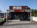
 view gallery view gallerySW8 km |  ALDI Store - Mount Kuring-gai, NSW, Australia ALDI Store - Mount Kuring-gai, NSW, Australia
in ALDI Stores Just off what used to be the BUSY Pacific Highway, is the Mount Kuring-gai ALDI store. There is a good sized car park below the store. Wheelchair access is by a lift, or a very long ramp. There are a few other shops here as well. posted by: Grahame Cookie location: New South Wales, Australia date approved: 02/18/2016 last visited: never |
 view gallery view galleryNE8.4 km |  Hawkesbury River Rail Bridge, Mooney, NSW, Australia Hawkesbury River Rail Bridge, Mooney, NSW, Australia
in Railroad Bridges Hawkesbury River Rail Bridge, Mooney, NSW, Australia posted by: Pensive Travellers location: New South Wales, Australia date approved: 07/07/2008 last visited: 03/02/2015 |
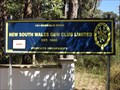 view gallery view galleryS9.3 km |  NSW Gun Club - Duffys Forest, NSW, Australia NSW Gun Club - Duffys Forest, NSW, Australia
in Shooting Ranges On Booralie Road, Duffys Forest, is the Clay Target Shooting Range for the NSW Gun Club. posted by: Grahame Cookie location: New South Wales, Australia date approved: 01/22/2018 last visited: never |
 view gallery view gallery N10.5 km N10.5 km
| Mooney Mooney Creek (Creek Below), NSW, Australia in Scenic Overlooks Mooney Mooney Creek (Creek Below), NSW, Australia posted by: Pensive Travellers location: New South Wales, Australia date approved: 08/05/2008 last visited: 09/30/2016 |
 view gallery view gallerySW10.5 km |  Mount Colah SDA, NSW, Australia Mount Colah SDA, NSW, Australia
in Seventh-day Adventist Churches Set beside the northern rail line, is this is 'small', but very active Adventist Church posted by: Grahame Cookie location: New South Wales, Australia date approved: 09/26/2016 last visited: never |
 view gallery view galleryS10.6 km | Anembo Reserve - You are here - Duffys Forest, NSW, Australia in 'You Are Here' Maps At the entrance to the Anembo Reserve is a sign that has a map showing where You are, just off of Anembo Road, near the Rural Fire Service, possibly on the way to the Horse Arena. posted by: Grahame Cookie location: New South Wales, Australia date approved: 01/05/2018 last visited: never |
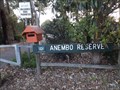 view gallery view galleryS10.6 km |  Anembo Reserve - Duffys Forest, NSW, Australia Anembo Reserve - Duffys Forest, NSW, Australia
in Public Access Lands At the end of Anembo Road is a small parking area opposite the Duffy's Forest Rural Fire Brigade, which gives access to the Anembo Reserve of walking and riding trails. posted by: Grahame Cookie location: New South Wales, Australia date approved: 01/06/2018 last visited: never |
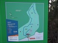 view gallery view galleryS10.6 km |  Anembo Reserve Trails - Duffys Forest, NSW, Australia Anembo Reserve Trails - Duffys Forest, NSW, Australia
in Hiking and walking trailheads Surrounded by the rugged Ku-ring-gai Chase National Park is this Reserve that allows horse riding, as well as walking on the sandy trails. posted by: Grahame Cookie location: New South Wales, Australia date approved: 01/18/2018 last visited: never |
 view gallery view galleryS10.6 km | Sandy trig, Duffys Forest, NSW in Australian Trig Points This is a delightful surprise of a stone cairn trig within the rural suburb of Duffys Forest on the northern 'beaches' of Sydney. Official Code: TS4023; Elevation: 198 metres. posted by: Grahame Cookie location: New South Wales, Australia date approved: 12/15/2016 last visited: never |
|