 view gallery view gallery N25.9 km N25.9 km
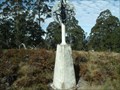
|   Omeo trig, Mernot/Niangala, NSW Omeo trig, Mernot/Niangala, NSW
in Australian Trig Points Between Nowendoc and Nundle, on the Great Dividing Range in northern new South Wales is another concrete pedestal trig. Official Code: TS6073; Elevation: 1350 metres posted by:  Grahame Cookie Grahame Cookie location: New South Wales, Australia date approved: 11/25/2016 last visited: never |
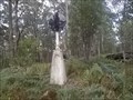 view gallery view gallery NE29 km NE29 km
| Kareela, Thunderbolts Way, NSW in Australian Trig Points This concrete pedestal trig is not far from the Thunderbolts Way, but is not visible from 'anywhere'.
Official Code: TS5668 posted by: Grahame Cookie location: New South Wales, Australia date approved: 05/24/2015 last visited: never |
 view gallery view gallery W34 km W34 km
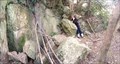
| ") Timor Caves, NSW Timor Caves, NSW
in Cave Entrances (Natural) The coordinates are for the TR1 "Main Cave". There is probably a hundred caves within half a kilometre of the camping area by the creek, off of Isaacs Creek Road. posted by: Grahame Cookie location: New South Wales, Australia date approved: 10/28/2014 last visited: never |
 view gallery view gallery S35.1 km S35.1 km
|  Alpine Dieback - Barrington Tops NP, NSW, Australia Alpine Dieback - Barrington Tops NP, NSW, Australia
in Flora and Fauna Information Signs This printed sign at Junction Pools explains the issue with the Alpine Dieback mould of the area. posted by: Grahame Cookie location: New South Wales, Australia date approved: 04/15/2024 last visited: never |
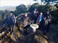
 view gallery view galleryS35.1 km |  Junction Pools - you are here - Barrington Tops NP, NSW, Australia Junction Pools - you are here - Barrington Tops NP, NSW, Australia
in 'You Are Here' Maps This covered sign shows where you are in Barrington Tops National Park. posted by: Grahame Cookie location: New South Wales, Australia date approved: 03/07/2024 last visited: never |
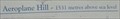 view gallery view galleryS35.6 km |  Aeroplane Hill - Barrington Tops, NSW, Australia - 1531m Aeroplane Hill - Barrington Tops, NSW, Australia - 1531m
in Elevation Signs This Historical Marker at Aeroplane Hill tells why this location is called so ... and gives its elevation - 1531 metres. posted by: Grahame Cookie location: New South Wales, Australia date approved: 06/20/2023 last visited: never |
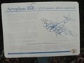
 view gallery view galleryS35.6 km |  Aeroplane Hill - Barrington Tops, NSW, Australia Aeroplane Hill - Barrington Tops, NSW, Australia
in Australian Historical Markers At the top of Aeroplane Hill is this Historical Marker on the A52-70 plane crash of 1945. T3 hiking access ONLY! posted by: Grahame Cookie location: New South Wales, Australia date approved: 04/21/2024 last visited: never |
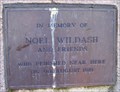
 view gallery view galleryS35.6 km |  A52-70 - Aeroplane Hill - Barrington Tops, NSW, Australia A52-70 - Aeroplane Hill - Barrington Tops, NSW, Australia
in Plane Crash Sites At the top of Aeroplane Hill is a plaque for the search of a RAAF Mosquito bomber in 1945. *See end re access* posted by: Grahame Cookie location: New South Wales, Australia date approved: 05/11/2023 last visited: never |
 view gallery view galleryS36.7 km | Cessna 210, VH-MDX, Barrington Tops, NSW, Australia in Plane Crash Sites 9 August, 1981 a Cessna 210, piloted by Michael Hutchins (with four passengers) was flying from Proserpine (Qld) to Bankstown (Sydney, NSW) when it was vectored towards Barrington Tops where it suffered an unknown fate, despite numerous searches. posted by: Grahame Cookie location: New South Wales, Australia date approved: 09/08/2015 last visited: never |
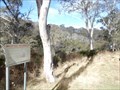
 view gallery view galleryS36.7 km | Barrington, Barrington Tops, NSW in Australian Trig Points This is about 4 km from a locked gate in the World Heritage listed Barrington Tops National Park. There is a small radio shed nearby. posted by:  MAP's MAP's location: New South Wales, Australia date approved: 09/11/2015 last visited: 05/20/2007 |
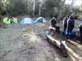 view gallery view galleryS37.5 km |  Careys Peak Hut site - Barrington Tops NP, NSW, Australia Careys Peak Hut site - Barrington Tops NP, NSW, Australia
in Free Campsites There is enough room for x10 small tents near the emergency shelter of Careys Peak Hut. posted by: Grahame Cookie location: New South Wales, Australia date approved: 04/21/2024 last visited: never |
 view gallery view galleryS37.5 km |  Careys Peak, Barrington Tops NP, NSW, Australia Careys Peak, Barrington Tops NP, NSW, Australia
in Remote Backcountry Shelters This corrugated iron 'storage shed' would be available in a dire emergency at Careys Peak camping area. This is about a 8 km walk from the nearest dirt road, and at an elevation of ~1,450 m, in a World Heritage National Park. posted by: Grahame Cookie location: New South Wales, Australia date approved: 09/04/2015 last visited: never |
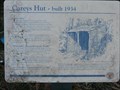 view gallery view galleryS37.5 km | Careys Hut - Barrington Tops NP, NSW, Australia in Australian Historical Markers Careys Hut, built in 1934, is a crude remote shelter for hikers on the Barrington Tops plateau at ~1450m. posted by: Grahame Cookie location: New South Wales, Australia date approved: 04/21/2024 last visited: never |
 view gallery view gallery NW37.5 km NW37.5 km
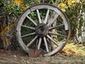
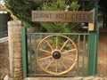
|  Wagon Wheel - Hanging Rock, NSW, Australia Wagon Wheel - Hanging Rock, NSW, Australia
in Wagon Wheels This wooden Wagon Wheel is leaning against a large tree at the front of this property. posted by: Grahame Cookie location: New South Wales, Australia date approved: 09/22/2019 last visited: never |
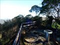
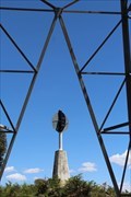
 view gallery view galleryS37.5 km |  Careys Peak Sundial - Barrington Tops NP, NSW, Australia Careys Peak Sundial - Barrington Tops NP, NSW, Australia
in Sundials This bronze Sundial is in a small fenced-off Lookout at Careys Trigpoint posted by: Grahame Cookie location: New South Wales, Australia date approved: 04/21/2024 last visited: never |
 view gallery view galleryS37.5 km |  Careys Peak Lookout - Barrington Tops NP, NSW, Australia Careys Peak Lookout - Barrington Tops NP, NSW, Australia
in Scenic Overlooks Certainly NOT a drive-by, but a T2½, or T3 hike required in Barrington Tops National Park. posted by: Grahame Cookie location: New South Wales, Australia date approved: 04/21/2024 last visited: never |
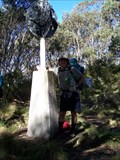
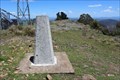
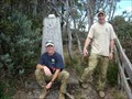 view gallery view galleryS37.5 km | Careys Peak, Barrington Tops National Park, NSW in Australian Trig Points Second highest peak in the Barrington Tops. posted by: Pensive Travellers location: New South Wales, Australia date approved: 05/07/2009 last visited: 05/19/2007 |
 view gallery view galleryNW37.5 km | Wagon Wheels - Hanging Rock, NSW, Australia in Wagon Wheels This pair of steel Wagon Wheels are built into the steel fencing either side of the entrance to this property. posted by: Grahame Cookie location: New South Wales, Australia date approved: 09/22/2019 last visited: never |
 view gallery view galleryS37.7 km |  Careys Peak Weather Station - Barrington Tops NP, NSW, Australia Careys Peak Weather Station - Barrington Tops NP, NSW, Australia
in Weather Stations This is one of Australia's higher Weather Stations, in Barrington Tops National Park. posted by: Grahame Cookie location: New South Wales, Australia date approved: 05/04/2024 last visited: never |
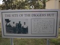 view gallery view galleryNW38.1 km | Diggers Hut - Hanging Rock, NSW, Australia in Australian Historical Markers A photographic sign at the front of the local Firehouse is the Historical Marker. posted by: Grahame Cookie location: New South Wales, Australia date approved: 09/22/2019 last visited: never |
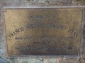 view gallery view galleryNW38.1 km |  Franky Ryan - Hanging Rock, NSW, Australia Franky Ryan - Hanging Rock, NSW, Australia
in Citizen Memorials This bronze plaque is for Franky Ryan, a volunteer Fire Fighter of the Hanging Rock Volunteer Fire Brigade. posted by: Grahame Cookie location: New South Wales, Australia date approved: 09/22/2019 last visited: never |
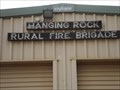 view gallery view galleryNW38.1 km |  Hanging Rock Rural Fire Brigade Hanging Rock Rural Fire Brigade
in Firehouses This is the Firehouse for the local volunteer Fire Brigade of Hanging Rock. posted by: Grahame Cookie location: New South Wales, Australia date approved: 09/22/2019 last visited: never |
 view gallery view galleryN38.6 km | Flags Trig near Nowendoc State Forest NSW in Australian Trig Points Flags Trig is on Black Sugarloaf Mountain at 1400 m elevation. Official Code: TS6069 posted by: John1041 location: New South Wales, Australia date approved: 11/11/2018 last visited: 12/17/2018 |
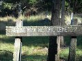 view gallery view galleryNW39.1 km |  Hanging Rock Historic Cemetery, Hanging Rock, NSW Hanging Rock Historic Cemetery, Hanging Rock, NSW
in Worldwide Cemeteries An historic cemetery surveyed in 1869 is beside the road in the locality of Hanging Rock. posted by: Tuena location: New South Wales, Australia date approved: 01/31/2012 last visited: 06/11/2015 |
 view gallery view galleryNW39.9 km | Yeerowin Trig at Hanging Rock State Forest NSW in Australian Trig Points Yeerowin Trig is at 1355m elevation on Baldy Knob in the Hanging Rock State Forest near Nundle NSW.
It is TS6201 posted by: John1041 location: New South Wales, Australia date approved: 12/23/2018 last visited: 05/06/2019 |
|