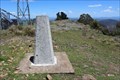
 view gallery view gallery SE10.8 km SE10.8 km
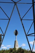
|   Flags Trig near Nowendoc State Forest NSW Flags Trig near Nowendoc State Forest NSW
in Australian Trig Points Flags Trig is on Black Sugarloaf Mountain at 1400 m elevation. Official Code: TS6069 posted by:  John1041 John1041 location: New South Wales, Australia date approved: 11/11/2018 last visited: 12/17/2018 |
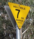 view gallery view gallerySE14.6 km |  Hell Hole, 7km Marker, Riamukka Area, NSW, Australia Hell Hole, 7km Marker, Riamukka Area, NSW, Australia
in Man-made Devilish Locations On the WINDY road to "Hell Hole" up on the "Great Dividing Range" of New South Wales, there are signs each kilometre reminding the driver to use their UHF radio, and gives a reference for them to use in warning the logging trucks. posted by:  Grahame Cookie Grahame Cookie location: New South Wales, Australia date approved: 07/14/2015 last visited: never |
 view gallery view gallery E18.2 km E18.2 km
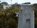
| Grundy GS, Riamukka Area/Walcha, NSW in Australian Trig Points Set right near the Grundy fire look out tower is this concrete pedestal trig, in the Riamukka Area. Official Code: TS5648; Elevation of 1463 metres. posted by: Grahame Cookie location: New South Wales, Australia date approved: 10/25/2016 last visited: never |
 view gallery view gallery S20.9 km S20.9 km
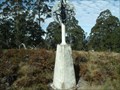
| Omeo trig, Mernot/Niangala, NSW in Australian Trig Points Between Nowendoc and Nundle, on the Great Dividing Range in northern new South Wales is another concrete pedestal trig. Official Code: TS6073; Elevation: 1350 metres posted by: Grahame Cookie location: New South Wales, Australia date approved: 11/25/2016 last visited: never |
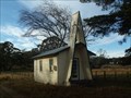 view gallery view galleryE23.8 km |  Brackendale, NSW, Australia Brackendale, NSW, Australia
in Country Churches South of Walcha, on Brackendale Road is this lonely church. posted by: Grahame Cookie location: New South Wales, Australia date approved: 09/25/2015 last visited: never |
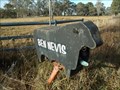 view gallery view gallery NE24 km NE24 km
|  Ben Nevis, Brackendale, NSW, Australia Ben Nevis, Brackendale, NSW, Australia
in Themed Homemade Mailboxes South of Walcha, almost opposite Lakes Rd on Brackendale Road is this black, beef Angus cattle shaped letter box for the Ben Nevis Angus cattle property. posted by: Grahame Cookie location: New South Wales, Australia date approved: 10/29/2015 last visited: never |
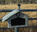 view gallery view galleryNE24 km | Homestead, Brackendale, NSW, Australia in Themed Homemade Mailboxes South of Walcha, on Brackendale Rd is this 'corrugated iron' letterbox, styled to look like a homestead. posted by: Grahame Cookie location: New South Wales, Australia date approved: 10/29/2015 last visited: never |
 view gallery view gallery SW29.6 km SW29.6 km
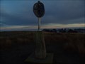
| Yeerowin Trig at Hanging Rock State Forest NSW in Australian Trig Points Yeerowin Trig is at 1355m elevation on Baldy Knob in the Hanging Rock State Forest near Nundle NSW.
It is TS6201 posted by: John1041 location: New South Wales, Australia date approved: 12/23/2018 last visited: 05/06/2019 |
 view gallery view gallery W30.3 km W30.3 km
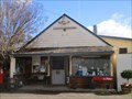
|  Woolomin CPA, NSW, 2340 Woolomin CPA, NSW, 2340
in Australia Post Offices The CPA in a small rural community posted by: blingg location: New South Wales, Australia date approved: 07/30/2022 last visited: never |
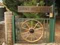
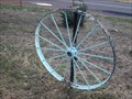 view gallery view galleryW31.1 km |  Wagon Wheels x 5 - Dungowan, NSW, Australia Wagon Wheels x 5 - Dungowan, NSW, Australia
in Wagon Wheels There are FIVE steel Wagon Wheels flanking the entrance to this property. posted by: Grahame Cookie location: New South Wales, Australia date approved: 06/30/2019 last visited: never |
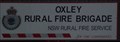 view gallery view galleryNE31.4 km |  Oxley Rural Fire Brigade Oxley Rural Fire Brigade
in Firehouses This Rural Fire Brigade is another volunteer brigade, south of Walcha, on the Brackendale road. posted by: Grahame Cookie location: New South Wales, Australia date approved: 12/18/2016 last visited: never |
 view gallery view galleryE32.8 km | Dennes, Great Dividing Range, NSW in Australian Trig Points Dennes trig is JUST outside of the Mummel Gulf National Park, south of Oxley Highway, NSW. It is a well constructed rock cairn, with wooden pole. Official Code: TS1806 posted by: Grahame Cookie location: New South Wales, Australia date approved: 11/29/2014 last visited: never |
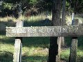 view gallery view gallerySW33 km |  Hanging Rock Historic Cemetery, Hanging Rock, NSW Hanging Rock Historic Cemetery, Hanging Rock, NSW
in Worldwide Cemeteries An historic cemetery surveyed in 1869 is beside the road in the locality of Hanging Rock. posted by: Tuena location: New South Wales, Australia date approved: 01/31/2012 last visited: 06/11/2015 |
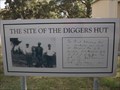 view gallery view gallerySW33.2 km |  Diggers Hut - Hanging Rock, NSW, Australia Diggers Hut - Hanging Rock, NSW, Australia
in Australian Historical Markers A photographic sign at the front of the local Firehouse is the Historical Marker. posted by: Grahame Cookie location: New South Wales, Australia date approved: 09/22/2019 last visited: never |
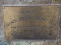 view gallery view gallerySW33.2 km |  Franky Ryan - Hanging Rock, NSW, Australia Franky Ryan - Hanging Rock, NSW, Australia
in Citizen Memorials This bronze plaque is for Franky Ryan, a volunteer Fire Fighter of the Hanging Rock Volunteer Fire Brigade. posted by: Grahame Cookie location: New South Wales, Australia date approved: 09/22/2019 last visited: never |
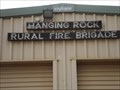 view gallery view gallerySW33.2 km | Hanging Rock Rural Fire Brigade in Firehouses This is the Firehouse for the local volunteer Fire Brigade of Hanging Rock. posted by: Grahame Cookie location: New South Wales, Australia date approved: 09/22/2019 last visited: never |
 view gallery view gallerySW33.3 km | Wagon Wheels - Hanging Rock, NSW, Australia in Wagon Wheels This pair of steel Wagon Wheels are built into the steel fencing either side of the entrance to this property. posted by: Grahame Cookie location: New South Wales, Australia date approved: 09/22/2019 last visited: never |
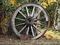 view gallery view gallerySW33.5 km | Wagon Wheel - Hanging Rock, NSW, Australia in Wagon Wheels This wooden Wagon Wheel is leaning against a large tree at the front of this property. posted by: Grahame Cookie location: New South Wales, Australia date approved: 09/22/2019 last visited: never |
 view gallery view galleryW34.4 km | Dungowan (former), NSW, 2340 in Australia Post Offices The former postal agency in a rural village posted by: blingg location: New South Wales, Australia date approved: 07/30/2022 last visited: never |
 view gallery view galleryNE35.1 km | Walcha GS, Walcha, NSW in Australian Trig Points 'Right' beside Brackendale Road, actually a few hundred metres into the property, is this beautiful, white-painted, concrete pedestal trig, with intact post, vanes and nameplate. Official Code: TS6273 posted by: Grahame Cookie location: New South Wales, Australia date approved: 01/20/2016 last visited: never |
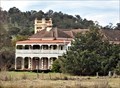 view gallery view gallery N35.6 km N35.6 km
|  Langford, Nowendoc Rd, Walcha, NSW, Australia Langford, Nowendoc Rd, Walcha, NSW, Australia
in Australian Heritage Sites Langford is historically significant, as it was on the flat near the Apsley River that John Oxley set up his camp on 8 September 1818. posted by: blingg location: New South Wales, Australia date approved: 07/27/2022 last visited: 08/13/2023 |
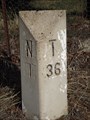 view gallery view gallerySW36 km |  River Rd, N1/T36 Milestone - Nundle, NSW, Australia River Rd, N1/T36 Milestone - Nundle, NSW, Australia
in Milestones This semi-worn Milestone is just out of the rural village of Nundle. posted by: Grahame Cookie location: New South Wales, Australia date approved: 09/24/2019 last visited: 07/07/2022 |
 view gallery view galleryE36.5 km | Porters, Mummel Gulf NP, NSW in Australian Trig Points Previously called Great Dividing Range Area on GCA, actually has nameplate of Porters. Behind the enclosed radio towers. Official Code: TS5651 posted by: Grahame Cookie location: New South Wales, Australia date approved: 11/29/2014 last visited: never |
 view gallery view gallerySW36.7 km |  Playground - Nundle, NSW, Australia Playground - Nundle, NSW, Australia
in Public Playgrounds This less than USUAL Playground is 'Wool Themed' and spread around a large woodchipped area near the Public Pool of Nundle. posted by: Grahame Cookie location: New South Wales, Australia date approved: 06/11/2022 last visited: never |
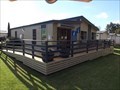 view gallery view gallerySW36.7 km |  Information Centre - Nundle, NSW, Australia Information Centre - Nundle, NSW, Australia
in Tourist Information Centers - Visitor Centers The Visitor Information Centre at Nundle also houses a good Gem and Mineral Collection. posted by: Grahame Cookie location: New South Wales, Australia date approved: 12/12/2022 last visited: never |
|