 view gallery view gallery E5 km E5 km
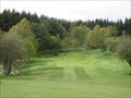
|   Aboyne Golf Club - Aberdeenshire, Scotland. Aboyne Golf Club - Aberdeenshire, Scotland.
in Public and Private Golf Courses Parkland/heathland golf course at the small town of Aboyne on Royal Deeside. posted by:  creg-ny-baa creg-ny-baa location: Northern Scotland, United Kingdom date approved: 05/10/2018 last visited: never |
 view gallery view gallery N5.3 km N5.3 km
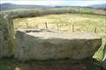
|  Tomnaverie Stone Circle - Tarland, Scotland, UK Tomnaverie Stone Circle - Tarland, Scotland, UK
in English Heritage - Cadw - Historic Scotland [EN] The Tomnaverie stone circle is a Bronze Age cromlech, comprising a massive lying stone. [FR] Le cercle de pierre de Tomnaverie est un cromlech daté de l'Âge du bronze, comportant une pierre couchée massive. posted by:  pmaupin pmaupin location: Northern Scotland, United Kingdom date approved: 04/23/2024 last visited: never |
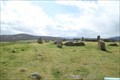 view gallery view galleryN5.3 km |  Tomnaverie Stone Circle - Tarland, Scotland, UK Tomnaverie Stone Circle - Tarland, Scotland, UK
in Wikipedia Entries [EN] The Tomnaverie stone circle is a Bronze Age cromlech, comprising a massive lying stone.
[FR] Le cercle de pierre de Tomnaverie est un cromlech daté de l'Âge du bronze, comportant une pierre couchée massive. posted by: pmaupin location: Northern Scotland, United Kingdom date approved: 04/21/2024 last visited: never |
 view gallery view gallery W5.8 km W5.8 km
|  AA Box - Cambus o' May AA Box - Cambus o' May
in Automobile Association Signs AA Call box situated in a laybay on stretch of A93 between Braemar and Aboyne, Aberdeenshire, Scotland. posted by: RandomPrecision location: Northern Scotland, United Kingdom date approved: 09/01/2013 last visited: 08/10/2013 |
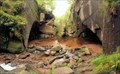 view gallery view galleryW6.3 km |  Burn O' Vat - Muir of Dinnet, Scotland Burn O' Vat - Muir of Dinnet, Scotland
in Places of Geologic Significance This Waymark shows you the amazing Burn o’ Vat. A large bowl created of glacial melt water. You can walk directly to the Vat from the parking place, or several recommended trails around that area. Walking in the Vat may requires waterproof boots. posted by: elrecke location: Northern Scotland, United Kingdom date approved: 09/25/2010 last visited: 08/11/2019 |
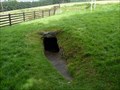 view gallery view galleryN7.6 km | Culsh Earth House - Tarland, Scotland, UK in English Heritage - Cadw - Historic Scotland An Earth House with 2000 years!! posted by: tmob location: Northern Scotland, United Kingdom date approved: 11/28/2012 last visited: never |
 view gallery view gallery NE8.7 km NE8.7 km
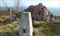
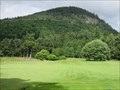
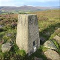
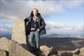
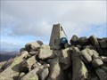
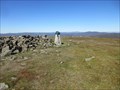
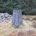
|  Top of Craiglich Mountain, NE Tarland, Scotland Top of Craiglich Mountain, NE Tarland, Scotland
in U.K. and Ireland Trigpoints A flush bracket on a triangulation pillar on the top of the mountain with great 360 degree views! posted by: lingbeek location: Northern Scotland, United Kingdom date approved: 09/30/2011 last visited: never |
 view gallery view gallery S10.9 km S10.9 km
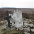
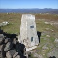
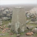
| O.S. Triangulation Pillar - Hill of Cat, Angus. in U.K. and Ireland Trigpoints Ordnance Survey trig pillar on the watershed of the Mounth Plateau in the eastern Grampians, on the Angus/Aberdeenshire border. posted by: creg-ny-baa location: Northern Scotland, United Kingdom date approved: 05/19/2019 last visited: never |
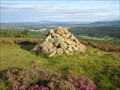
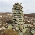 view gallery view galleryS11.4 km |  Cairn - Pullar Cuy, Angus, Scotland. Cairn - Pullar Cuy, Angus, Scotland.
in Cairns Mysterious leaning pillar-style near the summit of Pullar Cuy, a 636 metre height in the Eastern Grampians of Scotland. posted by: creg-ny-baa location: Northern Scotland, United Kingdom date approved: 04/23/2019 last visited: never |
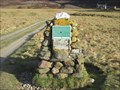
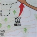 view gallery view galleryE11.7 km |  You Are Here - Corsedardar, Aberdeenshire, Scotland. You Are Here - Corsedardar, Aberdeenshire, Scotland.
in 'You Are Here' Maps 'You Are Here' on the B976 road at Corsedardar, in the parish of Birse in Aberdeenshire, next to two standing stones and the Birse War Memorial. posted by: creg-ny-baa location: Northern Scotland, United Kingdom date approved: 09/06/2020 last visited: never |
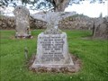
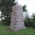 view gallery view galleryE11.7 km |  Birse Parish War Memorial - Aberdeenshire, Scotland. Birse Parish War Memorial - Aberdeenshire, Scotland.
in World War I Memorials and Monuments The war memorial dedicated to the men of the parish of Birse in Aberdeenshire, a tapering granite block set by the roadside of the B976. posted by: creg-ny-baa location: Northern Scotland, United Kingdom date approved: 09/03/2020 last visited: never |
 view gallery view galleryW12.2 km | Ballater Golf Club - Aberdeenshire, Scotland. in Public and Private Golf Courses Parkland/heathland golf course at the town of Ballater on the banks of the River Dee in Royal Deeside. posted by: creg-ny-baa location: Northern Scotland, United Kingdom date approved: 10/04/2017 last visited: never |
 view gallery view galleryE13.5 km | Tom's Cairn - Aberdeenshire, Scotland. in Cairns Tom's Cairn is a four foot high cairn on the summit of the hill of the same name in the Aberdeenshire countryside between the towns of Aboyne and Banchory. posted by: creg-ny-baa location: Northern Scotland, United Kingdom date approved: 09/08/2020 last visited: never |
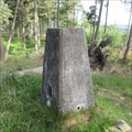
 view gallery view galleryE13.5 km | O.S. Triangulation Pillar - Tom's Cairn, Aberdeenshire. in U.K. and Ireland Trigpoints Ordnance Survey trig pillar, constructed in 1949, on the summit of Tom's Cairn, a 310 metre hill in Aberdeenshire between the towns of Aboyne and Banchory. posted by: creg-ny-baa location: Northern Scotland, United Kingdom date approved: 10/02/2020 last visited: never |
 view gallery view gallery SW13.5 km SW13.5 km
| Top of Mount Keen, Aberdeenshire, Scotland in U.K. and Ireland Trigpoints A triangulation pillar in the Grampian mountains on the top of the Munro Mount Keen. A Munro is a Scottish mountain with a height of more then 3000 feet. posted by: lingbeek location: Northern Scotland, United Kingdom date approved: 12/22/2013 last visited: 04/04/2017 |
 view gallery view gallerySW13.5 km |  Mount Keen - Aberdeenshire, Scotland. Mount Keen - Aberdeenshire, Scotland.
in Mountain Summits The most easterly 3000 foot summit in the UK. posted by: creg-ny-baa location: Northern Scotland, United Kingdom date approved: 04/19/2017 last visited: never |
 view gallery view gallery SE15.1 km SE15.1 km
| Mount Battock - Angus/Aberdeenshire, Scotland in Mountain Summits Summit of Mount Battock in the eastern Grampian Mountains of Scotland, the most easterly 2,500 foot plus mountain in Scotland. posted by: creg-ny-baa location: Northern Scotland, United Kingdom date approved: 06/22/2022 last visited: never |
 view gallery view gallerySE15.1 km | O.S. Triangulation Pillar - Mount Battock, Angus/Aberdeenshire in U.K. and Ireland Trigpoints Ordnance Survey trig pillar on the summit of Mount Battock, the most easterly Corbett in Scotland on the Angus/Aberdeenshire border in the eastern Grampian Mountains. posted by: creg-ny-baa location: Northern Scotland, United Kingdom date approved: 06/25/2022 last visited: never |
 view gallery view galleryE16.1 km | O.S. Triangulation Pillar - Hill of Tillylair, Aberdeenshire. in U.K. and Ireland Trigpoints Ordnance Survey trig pillar, constructed in 1949, on a hillock on the south side of a vast wooded area four miles west of the Aberdeenshire town of Banchory. posted by: creg-ny-baa location: Northern Scotland, United Kingdom date approved: 10/07/2020 last visited: never |
 view gallery view gallerySW16.6 km | Cairn, Glen Mark, Angus, Scotland. in Cairns Cairn next to the track at the head of Glen Mark with information about the Invermark Estate. posted by: creg-ny-baa location: Northern Scotland, United Kingdom date approved: 04/12/2017 last visited: never |
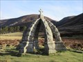 view gallery view galleryS16.6 km |  Queen's Well - Glen Mark, Angus. Queen's Well - Glen Mark, Angus.
in Artesian Well Historic Artesian Well in a remote glen in the Eastern Highlands of Scotland. posted by: creg-ny-baa location: Northern Scotland, United Kingdom date approved: 04/12/2017 last visited: never |
 view gallery view gallerySE17.1 km | O.S. Triangulation Pillar - Cuttie's Hillock, Aberdeenshire. in U.K. and Ireland Trigpoints Ordnance Survey trig pillar, constructed in 1949, in the midst of Cuttie's Wood, five miles south-west of Banchory in Aberdeenshire. posted by: creg-ny-baa location: Northern Scotland, United Kingdom date approved: 05/18/2020 last visited: never |
 view gallery view gallerySE17.2 km | O.S. Triangulation Pillar - Clachnaben, Aberdeenshire. in U.K. and Ireland Trigpoints Ordnance Survey trig pillar, constructed in 1950, on the summit area of the popular hill, Clachnaben, in the eastern Grampians of Aberdeenshire. posted by: creg-ny-baa location: Northern Scotland, United Kingdom date approved: 05/20/2019 last visited: never |
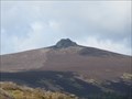 view gallery view gallerySE17.4 km | Clachnaben - Aberdeenshire, Scotland. in Wikipedia Entries Hill in the eastern Grampians of Scotland with a distinctive granite tor adorning its summit area. posted by: creg-ny-baa location: Northern Scotland, United Kingdom date approved: 05/01/2019 last visited: never |
 view gallery view galleryS18.2 km |  Blacksmith - William A. Fraser - Invermark, Angus. Blacksmith - William A. Fraser - Invermark, Angus.
in Occupational/Hobby Grave Stones Anvil headstone marking the grave of local blacksmith William Fraser and family in the churchyard of Lochlee Church at the head of Glen Esk in Angus, Scotland. posted by: creg-ny-baa location: Northern Scotland, United Kingdom date approved: 08/14/2020 last visited: never |
|