 view gallery view gallery SE2.7 km SE2.7 km
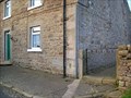
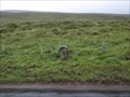
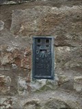
|   Grains o' th' Beck Flush Bracket 2313, County Durham Grains o' th' Beck Flush Bracket 2313, County Durham
in U.K. and Ireland Trigpoints Grains o' th' Beck was once a thriving community area. Now just the farm here with the early edition flush bracket. posted by:  flipflopnick flipflopnick location: North East England, United Kingdom date approved: 12/15/2008 last visited: 08/15/2009 |
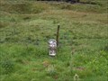
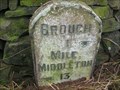
 view gallery view gallerySE2.7 km |  Grains o' th' Beck milestone, Brough 7, County Durham Grains o' th' Beck milestone, Brough 7, County Durham
in Milestones This is an iron mile marker on the old turnpike between Brough and Teesdale at the first crossing of the River Lune which flows into the river Tees. posted by: flipflopnick location: North East England, United Kingdom date approved: 12/14/2008 last visited: 08/15/2009 |
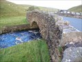 view gallery view gallerySE2.7 km |  Far Beck Bridge, Grains o th Beck, County Durham Far Beck Bridge, Grains o th Beck, County Durham
in Stone Bridges Far Beck bridge carries the B6276 down Lunedale towards Teesdale. posted by: flipflopnick location: North East England, United Kingdom date approved: 12/22/2008 last visited: 07/21/2010 |
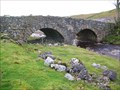 view gallery view gallerySE2.7 km | Grains o' th' Beck bridge, County Durham in Stone Bridges Grains o' th' Beck bridge was built by the London Lead Company, when the road was turnpiked. posted by: flipflopnick location: North East England, United Kingdom date approved: 12/22/2008 last visited: 07/21/2010 |
 view gallery view gallery SW2.9 km SW2.9 km
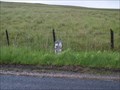
| Milestone Brough 5 on B6276 in County Durham in Milestones A milestone on the Brough to Middleton-in-Teesdale Turnpike which is now the B6276. posted by: Sir Lose-a-lot location: North East England, United Kingdom date approved: 08/13/2008 last visited: 08/13/2008 |
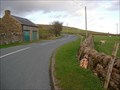
 view gallery view gallerySW3.4 km |  Cumbria Durham county boundary, B6276 road. Cumbria Durham county boundary, B6276 road.
in Border Crossings A cattle grid marks the change in tarmac and road authority at the county boundary, on the B6276. posted by: flipflopnick location: North West England, United Kingdom date approved: 10/21/2008 last visited: 07/21/2010 |
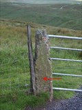
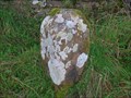
 view gallery view gallerySW3.4 km |  E45 boundary stone, near Cumbria Durham county border E45 boundary stone, near Cumbria Durham county border
in Public Land Survey Marks A stone with E45 inscribed on one face. This stone is a few metres from the road, just over the fence. This stone might be a meer stone. posted by: flipflopnick location: North West England, United Kingdom date approved: 12/22/2008 last visited: 07/21/2010 |
 view gallery view gallerySW4.3 km | Milestone Brough 4 on B6276 in Cumbria in Milestones A milestone on the Brough to Middleton-in-Teesdale Turnpike which is now the B6276. posted by: Sir Lose-a-lot location: United Kingdom date approved: 08/13/2008 last visited: 08/13/2008 |
 view gallery view gallery S4.5 km S4.5 km
| Iron Band Curry Stool, Brough, Cumbria in U.K. and Ireland Trigpoints On the broad top of Iron Band fell is a curry stool, which is a concrete three legged spider with a 5 cm bolt in the centre. posted by: flipflopnick location: North West England, United Kingdom date approved: 10/21/2008 last visited: never |
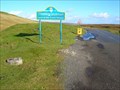
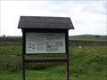
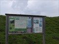
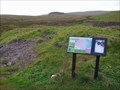 view gallery view gallerySW4.7 km |  North Stainmore Access Map, Cumbria North Stainmore Access Map, Cumbria
in 'You Are Here' Maps The area around B6276 road is open access fell. With the boundary of Warcop Training Firing Ranges to the north and A66 to south. The map explains where you can go. posted by: flipflopnick location: North West England, United Kingdom date approved: 12/14/2008 last visited: 07/21/2010 |
 view gallery view gallery E5.1 km E5.1 km
| Flush Bracket on Wemmergill Hall on B6276 in County Durham in U.K. and Ireland Trigpoints Flush bracket on Wemmergill Hall alongside the B6276 road from Middleton-in-Teesdale to Brough. posted by: Sir Lose-a-lot location: North East England, United Kingdom date approved: 08/13/2008 last visited: 08/13/2008 |
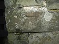
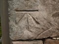
 view gallery view gallerySW5.8 km | Cut Benchmark on Gatepost on B6276 near Milestone Brough 3, Middleton 11 in U.K. and Ireland Trigpoints This benchmark is cut into the left hand gatepost at the start of track heading north off the B6276 posted by: Sir Lose-a-lot location: North West England, United Kingdom date approved: 08/13/2008 last visited: 08/13/2008 |
 view gallery view gallerySW5.8 km | Milestone Brough 3 on B6276 in Cumbria in Milestones A milestone on the Brough to Middleton-in-Teesdale Turnpike which is now the B6276. posted by: Sir Lose-a-lot location: North West England, United Kingdom date approved: 08/13/2008 last visited: 08/13/2008 |
 view gallery view gallery NE6.3 km NE6.3 km
|  High Force on the River Tees, County Durham High Force on the River Tees, County Durham
in Wikipedia Entries High Force is a splendid waterfall on the River Tees north-west of Middleton-in-Teesdale in County Durham. posted by: Sir Lose-a-lot location: United Kingdom date approved: 07/20/2008 last visited: 02/21/2013 |
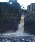 view gallery view galleryNE6.3 km |  High Force on the River Tees, County Durham High Force on the River Tees, County Durham
in Waterfalls High Force is a splendid waterfall on the River Tees north-west of Middleton-in-Teesdale in County Durham. posted by: Sir Lose-a-lot location: North East England, United Kingdom date approved: 07/20/2008 last visited: 02/21/2013 |
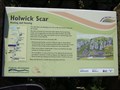 view gallery view galleryNE6.8 km | "You Are Here" Sign at the Holwick Scar, County Durham in 'You Are Here' Maps This YAH sign is at the base of Holwick Scars near Middleton-in-Teesdale. posted by: Sir Lose-a-lot location: United Kingdom date approved: 07/18/2008 last visited: 07/18/2008 |
 view gallery view gallerySW7.2 km | Milestone Brough 2 on B6276 in Cumbria in Milestones A milestone on the Brough to Middleton-in-Teesdale Turnpike which is now the B6276. posted by: Sir Lose-a-lot location: North West England, United Kingdom date approved: 08/13/2008 last visited: 08/13/2008 |
 view gallery view galleryNE7.2 km | Cut Bench Mark on Building near Holwick, County Durham in U.K. and Ireland Trigpoints Cut Bench mark on building alongside the road to Holwick, County Durham. posted by: Sir Lose-a-lot location: North East England, United Kingdom date approved: 07/29/2008 last visited: 07/29/2008 |
 view gallery view galleryE8 km | "You Are Here" Sign at Grassholme Reservoir, County Durham in 'You Are Here' Maps This "YAH" map is sited in the car park at the far end of Grassholme Reservoir which is in Lunedale in County Durham.
posted by: Sir Lose-a-lot location: United Kingdom date approved: 08/08/2008 last visited: 08/08/2008 |
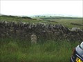
 view gallery view gallerySW8 km | Hazel Bank Boundary Stone, B6276, Cumbria in Public Land Survey Marks The worked stone marks the division between Stainmore and Brough townships. The stone is on the outside of a slight bend, raised up on a bank. posted by: flipflopnick location: North West England, United Kingdom date approved: 12/13/2008 last visited: 07/21/2010 |
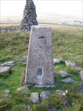 view gallery view gallerySE8.2 km | Shacklesborough Trig. Point, County Durham in U.K. and Ireland Trigpoints Shacklesborough Trig Point is located at the top of Baldersdale in County Durham. It keeps company with a very tall cairn which stands a few feet to the west. posted by: Sir Lose-a-lot location: North East England, United Kingdom date approved: 08/25/2009 last visited: 08/25/2009 |
 view gallery view gallerySE8.2 km |  Shacklesborough Trig. Point, County Durham Shacklesborough Trig. Point, County Durham
in European Historic Survey Stones, Monuments and Benchmarks Shacklesborough Trig Point is located at the top of Baldersdale in County Durham. It keeps company with a very tall cairn which stands a few feet to the west. There are great views all around. posted by: Sir Lose-a-lot location: North East England, United Kingdom date approved: 10/09/2010 last visited: 10/07/2010 |
 view gallery view gallerySW8.5 km | Brough 1 Middleton 13 milestone, Cumbria in Milestones The first milestone along the old turnpike route between Brough and Middleton-in-Teesdale. posted by: flipflopnick location: North West England, United Kingdom date approved: 12/23/2008 last visited: never |
 view gallery view gallerySE8.9 km | You Are Here Map at Balderhead Resr, County Durham. in 'You Are Here' Maps This map is in the car park alongside the dam of the Balderhead Reservoir. posted by: Sir Lose-a-lot location: United Kingdom date approved: 08/08/2008 last visited: 08/08/2008 |
 view gallery view gallerySW9.2 km | Cut Bench mark on Building at Lanehead Farm on B6276 near Brough in Cumbria in U.K. and Ireland Trigpoints Cut benchmark on corner of building near gate into Lanehead Farm on B6276 near Brough in Cumbria. posted by: Sir Lose-a-lot location: United Kingdom date approved: 08/13/2008 last visited: 08/13/2008 |
|