 view gallery view gallery W0.8 km W0.8 km
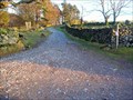
|   Green Road, Kentmere to Longsleddale, Cumbria Green Road, Kentmere to Longsleddale, Cumbria
in Offroad Trails This green road is used by mountain bikers and trail drivers on motor bikes and four wheel drive vehicles. Surface is loose stone and after rain heavily rutted. posted by:  flipflopnick flipflopnick location: North West England, United Kingdom date approved: 02/10/2008 last visited: 10/20/2011 |
 view gallery view gallery NE1.1 km NE1.1 km
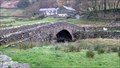
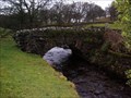
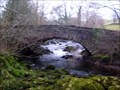
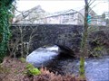
|  Sadgill Bridge, Cumbria Sadgill Bridge, Cumbria
in Stone Bridges Sadgill bridge is the last road bridge in the valley. The tarmac ends here. Originally a packhorse bridge. posted by: flipflopnick location: North West England, United Kingdom date approved: 11/19/2009 last visited: 02/18/2012 |
 view gallery view gallery NW1.1 km NW1.1 km
|  Kentmere Kentmere
in Wikipedia Entries Kentmere is an unspoilt valley in the south of Lake District. One of a few valleys without a lake, although there are some man made tarns along the river Kent. Mere means flat stretch of water. posted by: flipflopnick location: North West England, United Kingdom date approved: 02/10/2008 last visited: 04/23/2014 |
 view gallery view gallery SW1.9 km SW1.9 km
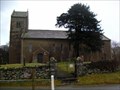
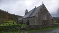
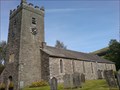
|  St. Cuthbert Church, Kentmere, Cumbria St. Cuthbert Church, Kentmere, Cumbria
in This Old Church St. Cuthbert church stands on a natural mound in the hamlet of Kentmere. posted by: flipflopnick location: North West England, United Kingdom date approved: 02/11/2008 last visited: 08/31/2012 |
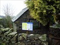 view gallery view gallerySW1.9 km |  Kentmere and Longsleddale Map, Cumbria Kentmere and Longsleddale Map, Cumbria
in 'You Are Here' Maps At the parking around Kentmere village hall and church is this map put here by the Lake District National Park Authority. posted by: flipflopnick location: North West England, United Kingdom date approved: 02/10/2008 last visited: never |
 view gallery view galleryNW2.6 km |  Ullstone Gill Footbridge, Kentmere, Cumbria Ullstone Gill Footbridge, Kentmere, Cumbria
in Hiking Path Footbridges Ullstone Gill is the stream that drains the boggy fellside below The Ull Stone, a large erratic boulder. The footbridge gets you across when the gill is flowing strongly. posted by: flipflopnick location: North West England, United Kingdom date approved: 02/10/2008 last visited: 02/11/2008 |
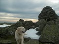
 view gallery view galleryNE3.2 km |  Tarn Crag Tarn Crag
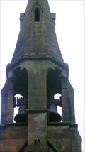
in Mountain Summits Tarn Crag (G/LD-026) This is the highest fell to the East of the Longsleddale valley in the Eastern Lake District. It has an interesting tower on the summit, which was used as a survey post during the construction of the Haweswater aguaduct. posted by:  charlieg0pzo charlieg0pzo location: United Kingdom date approved: 12/10/2006 last visited: 08/14/2014 |
 view gallery view gallery SE3.4 km SE3.4 km
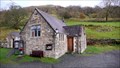
|  Longsleddale Parish School - Cumbria, UK Longsleddale Parish School - Cumbria, UK
in Former Schools The former valley school is now the community hall, with large car park for visitors walking. posted by: flipflopnick location: North West England, United Kingdom date approved: 11/18/2009 last visited: never |
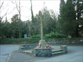
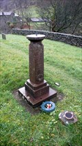 view gallery view gallerySE3.5 km |  Longsleddale Sundial, WW1+2 Longsleddale Sundial, WW1+2
in Non-Specific Veteran Memorials Longsleddale parishioners placed a sandstone sundial to remember the fallen in the First Great War. Those who fought in the Second World War are added on the east face. posted by: flipflopnick location: North West England, United Kingdom date approved: 11/23/2009 last visited: never |
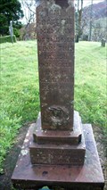 view gallery view gallerySE3.5 km |  Longsleddale Sundial (WW1) Longsleddale Sundial (WW1)
in World War I Memorials and Monuments Longsleddale parishioners erected a small sundial pedestal to remember their fallen. posted by: flipflopnick location: North West England, United Kingdom date approved: 11/18/2009 last visited: never |
 view gallery view gallerySE3.5 km | The Parish Church of St Mary , Longsleddale in This Old Church The Parish Church of St Mary is a small building with churchyard mid way along the Longsleddale valley. Opposite is a car park for visiting walkers and parishioners. posted by: flipflopnick location: North West England, United Kingdom date approved: 11/18/2009 last visited: never |
 view gallery view galleryNW4.5 km | Yoke- of the Kentmere mountains-Lake District Cumbria England. in Mountain Summits Yoke is the first mountain top summit reached on the Kentmere Horseshoe walk. posted by: Tashington location: United Kingdom date approved: 01/31/2009 last visited: 01/08/2015 |
 view gallery view gallery N4.5 km N4.5 km
| Harter fell, (Mardale) Cumbria, UK in Mountain Summits Harter Fell at the head of the Kentmere valley,and Mardale, cumbria. posted by: hillhiker1 location: North West England, United Kingdom date approved: 04/20/2010 last visited: 05/28/2015 |
 view gallery view galleryNW4.5 km | ILL Bell mountain-Lake District,Cumbria England. in Mountain Summits Ill Bell is a mountain in the Kentmere group of Fells,located in the Kentmere valley of The Lake District of Cumbria England. posted by: Tashington location: United Kingdom date approved: 01/31/2009 last visited: 01/08/2015 |
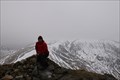 view gallery view galleryNW5.1 km | Froswick in Mountain Summits Froswick 720 m (2,362 ft) posted by: Kitebuggyboy & Ninkle location: North West England, United Kingdom date approved: 04/06/2010 last visited: 01/08/2015 |
 view gallery view gallery S5.1 km S5.1 km
| Hall Beck Bridge, Staveley, Cumbria in Stone Bridges The bridge over Hall Beck is an old packhorse bridge with modern walls added. posted by: flipflopnick location: North West England, United Kingdom date approved: 12/30/2007 last visited: 02/10/2008 |
 view gallery view galleryS5.6 km | Scroggs Bridge, Staveley, Cumbria in Stone Bridges Scroggs Bridge is north of Staveley, on the Kentmere valley road. posted by: flipflopnick location: North West England, United Kingdom date approved: 02/11/2008 last visited: never |
 view gallery view galleryS6.3 km | Barley Bridge, Staveley, Cumbria in Stone Bridges Barley Bridge is well used crossing to get on the back road from Staveley to Burneside. posted by: flipflopnick location: North West England, United Kingdom date approved: 02/11/2008 last visited: never |
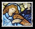 view gallery view galleryS6.4 km |  Angel in East Window of St James Church - Staveley, Cumbria Angel in East Window of St James Church - Staveley, Cumbria
in Philatelic Photographs For the Christmas stamps of 2009 several pre-Raphealite artists work was chosen. This is a part of the East window, left hand most light, of a blue Angel. Coordinates will get you to the church. posted by: flipflopnick location: North West England, United Kingdom date approved: 12/17/2012 last visited: never |
 view gallery view galleryW6.4 km | Jesus church Troutbeck,Lake District. in This Old Church Jesus church at Troutbeck is one of only 2 churches in England which is so named. posted by: fellsmanhiker location: United Kingdom date approved: 11/14/2008 last visited: 09/01/2010 |
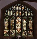 view gallery view galleryW6.4 km |  Stained Glass, Jesus Church, Troutbeck, Cumbria, UK Stained Glass, Jesus Church, Troutbeck, Cumbria, UK
in Stained Glass Windows An excellent set of stained glass windows, in particular the East window by Sir Edward Burne Jones. posted by: bill&ben location: North West England, United Kingdom date approved: 09/05/2010 last visited: never |
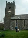
 view gallery view galleryW6.4 km |  Clock, Jesus Church, Troutbeck, Cumbria, UK Clock, Jesus Church, Troutbeck, Cumbria, UK
in Town Clocks The clock on Jesus Church was erected to celebrate Queen Victoria’s Jubilee in 1887 posted by: bill&ben location: North West England, United Kingdom date approved: 09/08/2010 last visited: never |
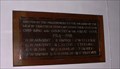 view gallery view galleryW6.4 km | War Memorial Plaques, Jesus Church, Troutbeck, Cumbria, UK in World War I Memorials and Monuments War memorial plaques within Jesus Church, Troutbeck. posted by: bill&ben location: North West England, United Kingdom date approved: 09/05/2010 last visited: never |
 view gallery view galleryS6.4 km |  St. James Church Bells, Staveley, Cumbria St. James Church Bells, Staveley, Cumbria
in Bell Towers There are two bells in the simple exposed turret of St. James Church. posted by: flipflopnick location: North West England, United Kingdom date approved: 12/15/2012 last visited: never |
 view gallery view galleryS6.4 km | War Memorial, Staveley, Cumbria in World War I Memorials and Monuments The war memorial in Staveley takes the form of a simple cross, at the junction of Brow Lane and Kentmere Road. Very close to the church. Like most memorial crosses, this memorial remembers both World Wars. posted by: flipflopnick location: North West England, United Kingdom date approved: 10/29/2016 last visited: never |
|