 view gallery view gallery SW2.3 km SW2.3 km
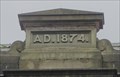
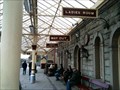
|   1874 Christ Church Wesleyan Chapel – Ramsbottom, UK 1874 Christ Church Wesleyan Chapel – Ramsbottom, UK
in Dated Buildings and Cornerstones This date stone is at the top of a Wesleyan Chapel. posted by:  dtrebilc dtrebilc location: North West England, United Kingdom date approved: 01/01/2012 last visited: never |
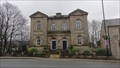 view gallery view gallerySW2.3 km |  Apartment Block - formerly Christ Church Wesleyan Chapel - Ramsbottom, UK Apartment Block - formerly Christ Church Wesleyan Chapel - Ramsbottom, UK
in This Old Church There was originally a Wesleyan Chapel on this site in 1825, but this building dates from 1874. posted by: dtrebilc location: North West England, United Kingdom date approved: 01/02/2012 last visited: never |
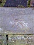
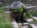 view gallery view gallery W2.3 km W2.3 km
|  Robin Hoods Well Robin Hoods Well
in Weird Story Locations The mark on the stone according to legend is the foot print of Robin Hood. posted by:  TeaMash TeaMash location: United Kingdom date approved: 02/21/2008 last visited: 10/16/2015 |
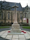
 view gallery view gallery S2.3 km S2.3 km
|  Combined World War Memorial Cross St Paul’s Church – Ramsbottom, UK Combined World War Memorial Cross St Paul’s Church – Ramsbottom, UK
in Churchyard Crosses This Latin Cross is a combined town memorial to the dead of World War I and World War II, in the churchyard of St Paul’s Anglican church in Ramsbottom, Lancashire posted by: dtrebilc location: North West England, United Kingdom date approved: 12/19/2010 last visited: never |
 view gallery view galleryS2.3 km |  Combined War Memorial, Ramsbottom, Lancashire, UK Combined War Memorial, Ramsbottom, Lancashire, UK
in World War I Memorials and Monuments Combined town memorial to the dead of World War 1 and World War 2 posted by: dtrebilc location: North West England, United Kingdom date approved: 10/31/2010 last visited: never |
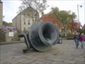 view gallery view gallerySW2.3 km |  Large Vase – Ramsbottom, UK Large Vase – Ramsbottom, UK
in Realistic Object Sculptures This sculpture is of a large vase tipped on its side. posted by: dtrebilc location: North West England, United Kingdom date approved: 11/28/2010 last visited: 08/27/2014 |
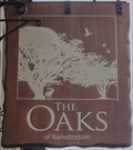 view gallery view gallerySW2.3 km |  The Oaks, 39 Bridge Street – Ramsbottom, UK The Oaks, 39 Bridge Street – Ramsbottom, UK
in Pictorial Pub Signs A modern, simple but interesting sign with a rural theme, that’s lost its royal connection with oak trees. posted by: dtrebilc location: North West England, United Kingdom date approved: 12/28/2011 last visited: never |
 view gallery view galleryW2.3 km | Ellen Strange's Cairn in Weird Story Locations Memorial Marker for Ellen Strange. posted by: TeaMash location: United Kingdom date approved: 02/21/2008 last visited: 01/31/2009 |
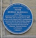 view gallery view gallerySW2.3 km |  Peter Murray McDouall – Ramsbottom, UK Peter Murray McDouall – Ramsbottom, UK
in Blue Plaques Peter McDouall (1814-1854) was a doctor who having seen the poor living conditions of the local mill workers joined the Chartist movement and petitioned parliament. posted by: dtrebilc location: North West England, United Kingdom date approved: 01/18/2012 last visited: never |
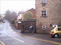
 view gallery view galleryS2.3 km |  Railway Station Waiting Rooms - Ramsbottom, UK Railway Station Waiting Rooms - Ramsbottom, UK
in Gender Separated Entrances Old railway stations often had separate ladies only waiting rooms in the UK. posted by: dtrebilc location: North West England, United Kingdom date approved: 01/22/2011 last visited: never |
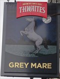 view gallery view gallerySW2.4 km | The Grey Mare, 25 Bolton Street – Ramsbottom, UK in Pictorial Pub Signs This sign shows a rearing grey horse on the night of a full moon. posted by: dtrebilc location: North West England, United Kingdom date approved: 12/28/2011 last visited: never |
 view gallery view gallery NE3.2 km NE3.2 km
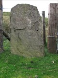
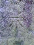
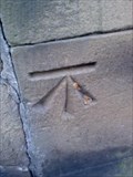
|  Cut Mark near summit of Black Hill in Rossendale Cut Mark near summit of Black Hill in Rossendale
in European Historic Survey Stones, Monuments and Benchmarks Cut Mark carved into a stone in the wall. posted by: mountainmate location: North West England, United Kingdom date approved: 08/16/2011 last visited: never |
 view gallery view galleryNE3.2 km | Cut Mark near Black Hill Rossendale in European Historic Survey Stones, Monuments and Benchmarks Cut Mark on Stone Gate post. posted by: mountainmate location: North West England, United Kingdom date approved: 08/16/2011 last visited: never |
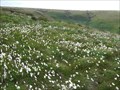 view gallery view galleryW3.2 km |  Cotton-grass on moorland Rossendale, Lancashire Cotton-grass on moorland Rossendale, Lancashire
in Flower Fields Mid-summer seeding of cotton grass or cotton-sedge on the moorland above Helmshore, Rossendale posted by: Aldenbob location: North West England, United Kingdom date approved: 10/25/2008 last visited: 06/28/2008 |
 view gallery view gallery E3.4 km E3.4 km
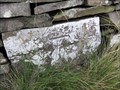
| Pivot near Cragg quarry in European Historic Survey Stones, Monuments and Benchmarks Pivot mark cut into stone beside the track that runs below Cragg quarries posted by: mountainmate location: North West England, United Kingdom date approved: 08/16/2011 last visited: never |
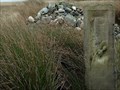
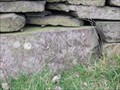
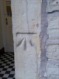
 view gallery view gallerySW3.9 km |  Cut Mark- Moor Bottom Road, Holcombe, Bury. Cut Mark- Moor Bottom Road, Holcombe, Bury.
in U.K. and Ireland Trigpoints A cut bench mark on a stone gate post on Moor Bottom Road,
Holcombe in Bury. posted by: Dave_S+Net location: North West England, United Kingdom date approved: 03/09/2009 last visited: never |
 view gallery view galleryE4 km | Cut Mark north of Cowpe Moss in European Historic Survey Stones, Monuments and Benchmarks Cut Mark in stone gate post on path below, and to the North of, Cragg quarries in Rossendale. posted by: mountainmate location: North West England, United Kingdom date approved: 08/16/2011 last visited: never |
 view gallery view gallerySW6.3 km |  The Dungeon The Dungeon
in Retired Prisons The Dungeon posted by: m0sgb location: North West England, United Kingdom date approved: 09/25/2006 last visited: 09/27/2006 |
 view gallery view galleryS6.3 km | NBM Cut Mark, How Lane, Bury.(Burrs Country Park) in U.K. and Ireland Trigpoints A NBM cut bench mark on the North Side of How Lane in Bury. This is now actually part of Burrs Country Park. posted by: Dave_S+Net location: North West England, United Kingdom date approved: 03/09/2009 last visited: never |
 view gallery view galleryS6.4 km | Mousetrap – Bury, UK in Realistic Object Sculptures This giant size mousetrap is at Burrs country park in Bury. posted by: dtrebilc location: North West England, United Kingdom date approved: 02/19/2011 last visited: never |
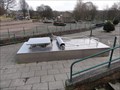
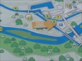
 view gallery view galleryS6.4 km |  Burrs Country Park “You Are Here” map – Bury, UK Burrs Country Park “You Are Here” map – Bury, UK
in 'You Are Here' Maps You are in Burrs Country Park, and this map shows you where fishing is allowed. posted by: dtrebilc location: Yorkshire, United Kingdom date approved: 03/30/2011 last visited: never |
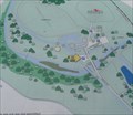
 view gallery view galleryS6.4 km | Welcome To Burrs Country Park “You Are Here” map – Bury, UK in 'You Are Here' Maps You are in Burrs Country Park. posted by: dtrebilc location: Yorkshire, United Kingdom date approved: 03/30/2011 last visited: never |
 view gallery view gallerySW6.8 km | Cut Mark- Black Bull Pub, Edgworth in U.K. and Ireland Trigpoints A cut bench mark on the doorway of the Black Bull pub, Bolton Road, Edgworth. posted by: Dave_S+Net location: United Kingdom date approved: 11/03/2008 last visited: never |
 view gallery view gallerySW6.9 km | Cut Mark- Turton Bottoms Bridge, Edgworth. in U.K. and Ireland Trigpoints A cut bench mark on Turton Bottoms bridge, Bolton Road, Edgworth. posted by: Dave_S+Net location: United Kingdom date approved: 10/28/2008 last visited: never |
 view gallery view galleryW7.4 km | Cut Mark & Rivet- Rock, Entwistle Hall Lane, Edgworth. in U.K. and Ireland Trigpoints A cut mark & rivet on a domed rock on Entwistle Hall Lane, Edgworth.
The rock is located at a junction of walls on the North side of the railway bridge. posted by: Dave_S+Net location: United Kingdom date approved: 11/03/2008 last visited: never |
|