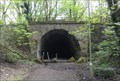
 view gallery view gallery W0.8 km W0.8 km
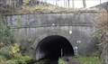
|   Brinnington Tunnel - Portwood, UK Brinnington Tunnel - Portwood, UK
in Abandoned Train Tunnels This tunnel was part of a two mile long Stockport (Portwood) to Woodley railway and is now used by cyclists, walkers and horse riders. posted by:  dtrebilc dtrebilc location: North West England, United Kingdom date approved: 05/04/2018 last visited: never |
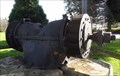 view gallery view galleryW1.4 km |  Portwood Mills Water Turbine - Portwood, UK Portwood Mills Water Turbine - Portwood, UK
in Preserved Machines on Public Display This water turbine used to be used to power machinery in Portwood Mills. posted by: dtrebilc location: North West England, United Kingdom date approved: 04/13/2019 last visited: never |
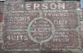 view gallery view gallery SW2.1 km SW2.1 km
|  Emersons - Stockport, UK Emersons - Stockport, UK
in Ghost Signs This white painted sign on a bare brick wall advertises a tailor business. The building's modern use is Blackshaw's Cafe. posted by: dtrebilc location: North West England, United Kingdom date approved: 02/02/2016 last visited: never |
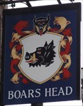 view gallery view gallerySW2.1 km |  Boars Head, 1 Vernon Street - Stockport, UK Boars Head, 1 Vernon Street - Stockport, UK
in Pictorial Pub Signs This pub stnads near to Stockport Covered Market and was built in the early 19th Century. posted by: dtrebilc location: North West England, United Kingdom date approved: 01/29/2016 last visited: never |
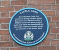 view gallery view gallerySW2.1 km |  Castle Yard - Stockport, UK Castle Yard - Stockport, UK
in Blue Plaques This blue plaque is on the wall of a pub. It commemorates the fact that it is on the site of a castle that was built in 1173. posted by: dtrebilc location: North West England, United Kingdom date approved: 01/28/2016 last visited: never |
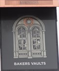 view gallery view gallerySW2.1 km | Bakers Vaults, Castle Yard - Stockport, UK in Pictorial Pub Signs This pub was refurbished in July 2014 and its new sign shows part of the pub building. posted by: dtrebilc location: North West England, United Kingdom date approved: 01/27/2016 last visited: never |
 view gallery view gallery E2.1 km E2.1 km
|  Hope Valley Line Brick Railway Bridge – Bredbury, UK Hope Valley Line Brick Railway Bridge – Bredbury, UK
in Arch Bridges This brick built arch railway bridge carries the Hope Valley railway line over the Peak Forest Canal. posted by: dtrebilc location: North West England, United Kingdom date approved: 11/09/2014 last visited: never |
 view gallery view galleryE2.1 km |  Hope Valley Line Railway Bridge – Bredbury, UK Hope Valley Line Railway Bridge – Bredbury, UK
in Railroad Bridges This brick built arch railway bridge carries the Hope Valley railway line over the Peak Forest Canal. posted by: dtrebilc location: North West England, United Kingdom date approved: 12/02/2014 last visited: never |
 view gallery view galleryE2.1 km | Stone Bridge 13 On The Peak Forest Canal – Bredbury, UK in Arch Bridges This stone arch road bridge carries Gilbertbank Road over the Peak Forest Canal. posted by: dtrebilc location: North West England, United Kingdom date approved: 11/09/2014 last visited: never |
 view gallery view galleryE2.1 km |  Arch Bridge 13 On The Peak Forest Canal – Bredbury, UK Arch Bridge 13 On The Peak Forest Canal – Bredbury, UK
in Stone Bridges This stone arch road bridge carries Gilbertbank Road over the Peak Forest Canal. posted by: dtrebilc location: North West England, United Kingdom date approved: 11/11/2014 last visited: never |
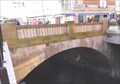 view gallery view gallerySW2.1 km | Lancashire Bridge - Stockport, UK in Arch Bridges This single arch bridge crosses the River Mersey close to its start after the River Goyt and River Tame meet. posted by: dtrebilc location: North West England, United Kingdom date approved: 01/30/2016 last visited: never |
 view gallery view gallerySW2.1 km | Single Arch Lancashire Bridge Over River Mersey - Stockport, UK in Stone Bridges This single arch bridge crosses the River Mersey close to its start after the River Goyt and River Tame meet. posted by: dtrebilc location: North West England, United Kingdom date approved: 02/01/2016 last visited: never |
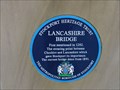 view gallery view gallerySW2.1 km | Lancashire Bridge - Stockport, UK in Blue Plaques This blue plaque commemorates Lancashire Bridge across the River Mersey in the middle of the town of Stockport on the border of Lancashire and Cheshire. posted by: dtrebilc location: North West England, United Kingdom date approved: 02/01/2016 last visited: never |
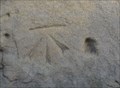 view gallery view gallerySW2.1 km |  Cut Bench Mark On St. Petersgate - Stockport, UK Cut Bench Mark On St. Petersgate - Stockport, UK
in U.K. and Ireland Trigpoints This cut mark is on the side of a building next to steps that descend from St. Petersgate Bridge to Underbank, the road that passes under the bridge. posted by: dtrebilc location: North West England, United Kingdom date approved: 01/18/2016 last visited: never |
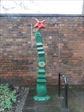
 view gallery view gallerySW2.1 km |  SUSTRANS Millennium Milestone – Stockport, UK SUSTRANS Millennium Milestone – Stockport, UK
in Milestones This is one of 1000 cycle path mileposts sponsored by Royal Bank of Scotland to celebrate both the millennium and the SUSTRANS national cycle network. posted by: dtrebilc location: North West England, United Kingdom date approved: 01/31/2016 last visited: never |
 view gallery view gallerySW2.1 km |  SUSTRANS Millennium Milestone – Stockport, UK SUSTRANS Millennium Milestone – Stockport, UK
in Made for the Millennium This is one of 1000 cycle path mileposts sponsored by Royal Bank of Scotland to celebrate both the millennium and the SUSTRANS national cycle network. posted by: dtrebilc location: North West England, United Kingdom date approved: 02/02/2016 last visited: never |
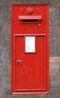 view gallery view gallerySW2.1 km |  Underbank Wall Post Box - Stockport, UK Underbank Wall Post Box - Stockport, UK
in Victorian Post Boxes This Victorian post box is set into a wall in Underbank next to St. Petersgate Bridge. posted by: dtrebilc location: North West England, United Kingdom date approved: 01/25/2016 last visited: never |
 view gallery view gallery NW2.1 km NW2.1 km
| SUSTRANS Millennium Milestone - Reddish Vale, UK in Made for the Millennium This is one of 1000 cycle path mileposts sponsored by Royal Bank of Scotland to celebrate both the millennium and the SUSTRANS national cycle network. posted by: dtrebilc location: North West England, United Kingdom date approved: 05/04/2018 last visited: never |
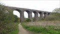 view gallery view galleryNW2.1 km | Sheffield And Midland Railways Viaduct - Reddish Vale, UK in Arch Bridges This working railway viaduct was built in 1875. posted by: dtrebilc location: North West England, United Kingdom date approved: 05/04/2018 last visited: never |
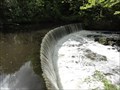 view gallery view gallery NE2.1 km NE2.1 km
|  Arden Mill Weir - Bredbury, UK Arden Mill Weir - Bredbury, UK
in Man-made Waterfalls This is one of three weirs on the River Tame in Tameside on the Trans Pennine Trail. posted by: dtrebilc location: North West England, United Kingdom date approved: 08/21/2018 last visited: never |
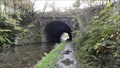
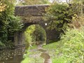
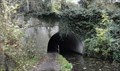 view gallery view galleryE2.1 km |  South Portal - Woodley Tunnel - Peak Forest Canal - Woodley, UK South Portal - Woodley Tunnel - Peak Forest Canal - Woodley, UK
in Canal Tunnels Woodley tunnel on the Peak Forest Canal was built between 1794 and 1801 and is 176 yards long. posted by: dtrebilc location: North West England, United Kingdom date approved: 11/09/2014 last visited: 05/03/2015 |
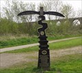
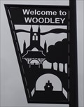 view gallery view galleryE2.3 km |  Woodley Welcome Sign - Woodley, UK Woodley Welcome Sign - Woodley, UK
in Artistic Welcome Signs This black metal silhouette sign shows some of the sites that can be seen nearby in the town of Woodley. posted by: dtrebilc location: North West England, United Kingdom date approved: 11/09/2014 last visited: never |
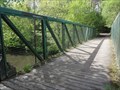 view gallery view galleryNE2.3 km |  Pedestrian Truss Bridge Over River Tame - Bredbury, UK Pedestrian Truss Bridge Over River Tame - Bredbury, UK
in Truss Bridges This foot bridge carries a footpath over the River Tame. posted by: dtrebilc location: North West England, United Kingdom date approved: 08/17/2018 last visited: never |
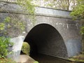
 view gallery view galleryE2.3 km | North Portal - Woodley Tunnel - Peak Forest Canal - Woodley, UK in Canal Tunnels Woodley tunnel on the Peak Forest Canal was built between 1794 and 1801 and is 176 yards long. posted by: dtrebilc location: North West England, United Kingdom date approved: 11/09/2014 last visited: 05/03/2015 |
 view gallery view galleryE2.3 km |  Romiley Canal Bridge - 1797, 1908 and 1992 - Romiley, UK Romiley Canal Bridge - 1797, 1908 and 1992 - Romiley, UK
in Bridge Date Stones and Plaques This road bridge carries Stockport Road over the Peak Forest Canal in the town of Romiley. posted by: dtrebilc location: North West England, United Kingdom date approved: 11/11/2014 last visited: never |
|