 view gallery view gallery W7.2 km W7.2 km
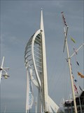
|   Flag Pole - Spinnaker Tower Portsmouth, UK Flag Pole - Spinnaker Tower Portsmouth, UK
in Nautical Flag Poles Flag Pole beside Spinnaker Tower Portsmouth posted by:  ToRo61 ToRo61 location: South East England, United Kingdom date approved: 12/30/2011 last visited: 05/03/2017 |
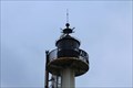
 view gallery view gallery NW21.2 km NW21.2 km
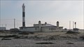
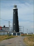
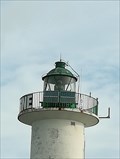
|  Dungeness Lighthouse (current) - Kent, UK Dungeness Lighthouse (current) - Kent, UK
in Coastal Lighthouses A lighthouse overlooking the south east entrance to the Dover Strait. posted by:  Master Mariner Master Mariner location: South East England, United Kingdom date approved: 05/20/2011 last visited: 07/11/2017 |
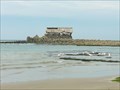
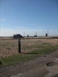 view gallery view galleryNW21.4 km |  Dungeness - Kent, UK Dungeness - Kent, UK
in Yellow Arrow Lookup The end of the line Yellow Arrow is shown by the old, collapsed shed on the large shingle beach of Dungeness. It is a unique environment of stark contrast to the modern hubbub. posted by: Dragontree location: South East England, United Kingdom date approved: 03/29/2012 last visited: 07/20/2016 |
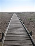 view gallery view galleryNW21.4 km |  Dungeness Boardwalk - Kent, UK Dungeness Boardwalk - Kent, UK
in Coastal Boardwalks This boardwalk has been built to protect the unique life on the shingle beach of Dungeness. posted by: Dragontree location: South East England, United Kingdom date approved: 04/29/2012 last visited: 05/30/2016 |
 view gallery view galleryNW21.4 km |  Dungeness A National Nature Reserve - Kent, UK Dungeness A National Nature Reserve - Kent, UK
in Flora and Fauna Information Signs A colourful information board can be seen here about Dungeness and its National Nature Reserve. posted by: Dragontree location: South East England, United Kingdom date approved: 04/11/2012 last visited: 05/30/2016 |
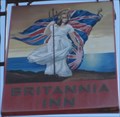 view gallery view galleryNW21.4 km |  Britannia Inn - Dungeness, Kent, UK Britannia Inn - Dungeness, Kent, UK
in Pictorial Pub Signs The Britannia Inn is located in the unique environment and village of Dungeness. It belongs to the Shepherd Neame brewery which is the oldest brewer in Britain, established in 1698. posted by: Dragontree location: South East England, United Kingdom date approved: 04/09/2012 last visited: 05/30/2016 |
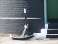
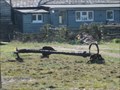 view gallery view galleryNW21.6 km |  Anchor at Dungeness - Kent, UK Anchor at Dungeness - Kent, UK
in Anchors This old anchor can be seen in a garden at Dungeness. posted by: Dragontree location: South East England, United Kingdom date approved: 04/09/2012 last visited: 05/30/2016 |
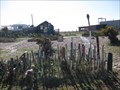 view gallery view galleryNW21.6 km |  Paintbrush Pad - Dungeness, Kent, UK Paintbrush Pad - Dungeness, Kent, UK
in Junk Design Houses Paintbrushes are growing in a large quantity in this garden at Dungeness. posted by: Dragontree location: South East England, United Kingdom date approved: 04/09/2012 last visited: 05/30/2016 |
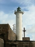
 view gallery view galleryNW21.7 km | The Old Lighthouse at Dungeness Kent in Coastal Lighthouses For over a hundred years the coastal waters of South East Kent have been overlooked by The Old Lighthouse at Dungeness. posted by: Blue Man location: United Kingdom date approved: 02/10/2006 last visited: 07/11/2017 |
 view gallery view galleryNW21.7 km | Anchor at the Old Lighthouse - Dungeness, Kent, UK in Anchors Outside the entrance door to the old lighthouse in Dungeness lies this small anchor. posted by: Dragontree location: South East England, United Kingdom date approved: 04/09/2012 last visited: 05/30/2016 |
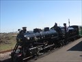 view gallery view galleryNW21.7 km |  RH&DR - Dungeness, Kent, UK RH&DR - Dungeness, Kent, UK
in Scenic Railroads Here at Dungeness is the most southerly station on the Romney, Hythe & Dymchurch Railway. The flat, shingle expanse may be forgiven for its excellent camouflage of this scenic railway. posted by: Dragontree location: South East England, United Kingdom date approved: 04/12/2012 last visited: 07/11/2017 |
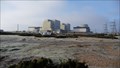 view gallery view galleryNW21.7 km |  Dungeness Power Station - Romney Marsh Dungeness Power Station - Romney Marsh
in Nuclear Power Plants A nuclear plant of the south coast of England facing the English Channel. posted by: Master Mariner location: South East England, United Kingdom date approved: 05/01/2011 last visited: 05/30/2016 |
 view gallery view galleryNW22.7 km |  Lydd-on-Sea - Dungeness - Kent, UK Lydd-on-Sea - Dungeness - Kent, UK
in Coats of Arms Dungeness is a corporate member of the Cinque Ports of Kent and this is marked by a pictorial sign which includes the coat of arms of Lydd-on-Sea. posted by: Dragontree location: South East England, United Kingdom date approved: 04/08/2012 last visited: 09/09/2017 |
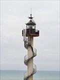
 view gallery view gallery E25.7 km E25.7 km
| Phare de la digue Carnot - Boulogne-sur-mer - Pas-de-Calais - France in Coastal Lighthouses [EN] Lighthouse Boulogne-sur-Mer in the Pas-de-Calais, is a lighthouse classified "sea lighthouse".
[FR] Le phare de Boulogne-sur-Mer, dans le Pas-de-Calais, est un phare classé « phare en mer ». posted by: pmaupin location: Hauts-de-France, France date approved: 11/26/2016 last visited: 08/13/2019 |
 view gallery view galleryE25.7 km |  Phare de la digue Carnot - Boulogne-sur-mer, France Phare de la digue Carnot - Boulogne-sur-mer, France
in Wikipedia Entries [EN] Lighthouse Boulogne-sur-Mer in the Pas-de-Calais, is a lighthouse classified "sea lighthouse".
[FR] Le phare de Boulogne-sur-Mer, dans le Pas-de-Calais, est un phare classé « phare en mer ». posted by: pmaupin location: Hauts-de-France, France date approved: 08/14/2019 last visited: 08/13/2019 |
 view gallery view galleryE25.7 km |  Benchmark - Point Géodésique - Phare de la digue Carnot - Boulogne-sur-mer, France Benchmark - Point Géodésique - Phare de la digue Carnot - Boulogne-sur-mer, France
in French Benchmarks Repère géodésique du point e, à la base du paratonnerre. posted by: pmaupin location: Hauts-de-France, France date approved: 08/14/2019 last visited: 08/14/2019 |
 view gallery view galleryE26.2 km |  Fort de l'Heurt - Le-Portel, France Fort de l'Heurt - Le-Portel, France
in La Famille Bonaparte [EN] Fort de l'Heurt is a fort built on the orders of Napoleon Bonaparte on remains of the former promontory Icius of the geographer Ptolemy.
[FR] Le Fort de l'Heurt est un fort élevé sur ordre de Napoléon Bonaparte sur des vestiges de l'ancien promontoire Icius du géographe Ptolémée. posted by: pmaupin location: Hauts-de-France, France date approved: 09/27/2019 last visited: 10/14/2020 |
 view gallery view galleryE26.2 km |  Fort de l'Heurt - Le-Portel, France Fort de l'Heurt - Le-Portel, France
in Official Local Tourism Attractions [EN] Fort de l'Heurt is a fort built on the orders of Napoleon Bonaparte on remains of the former promontory Icius of the geographer Ptolemy.
[FR] Le Fort de l'Heurt est un fort élevé sur ordre de Napoléon Bonaparte sur des vestiges de l'ancien promontoire Icius du géographe Ptolémée. posted by: pmaupin location: Hauts-de-France, France date approved: 10/15/2018 last visited: 10/14/2020 |
 view gallery view galleryE26.2 km | Fort de l'Heurt - Le-Portel, France in Wikipedia Entries [EN] Fort de l'Heurt is a fort built on the orders of Napoleon Bonaparte on remains of the former promontory Icius of the geographer Ptolemy.
[FR] Le Fort de l'Heurt est un fort élevé sur ordre de Napoléon Bonaparte sur des vestiges de l'ancien promontoire Icius du géographe Ptolémée. posted by: pmaupin location: Hauts-de-France, France date approved: 10/15/2018 last visited: 10/15/2018 |
 view gallery view galleryE26.2 km |  Le fort de l’Heurt, sentinelle du Portel qui ne sera pas éternelle - Le Portel, France Le fort de l’Heurt, sentinelle du Portel qui ne sera pas éternelle - Le Portel, France
in News Article Locations [EN] A press article of the original images of the Boulonnais captured from a helicopter by the photographer Olivier Caenen
[FR] Un article de presse des images originales du Boulonnais capturées depuis un hélicoptère par le photographe Olivier Caenen. posted by: pmaupin location: Hauts-de-France, France date approved: 10/15/2018 last visited: 10/15/2018 |
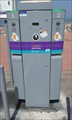 view gallery view galleryE26.9 km |  Station de rechargement électrique, quai de la violette - Le Portel, France Station de rechargement électrique, quai de la violette - Le Portel, France
in Electric Car Charging Stations [EN] Point of load for electric vehicles on the violet dock in Le Portel.
[FR] Point de charge pour véhicules électriques sur le quai de la violette à Le Portel posted by: pmaupin location: Hauts-de-France, France date approved: 05/27/2017 last visited: 05/26/2017 |
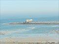
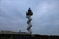
 view gallery view gallery SE26.9 km SE26.9 km
|  Phare du Cap d'Alprech - Le-Portel, France Phare du Cap d'Alprech - Le-Portel, France
in Puzzles in the Real World [EN] The lighthouse of Cape Alprech, built in 1962 in the town of Portel. [FR] Le phare du Cap d'Alprech, construit en 1962 sur la commune du Portel. posted by: pmaupin location: Hauts-de-France, France date approved: 12/13/2021 last visited: 12/13/2021 |
 view gallery view gallerySE26.9 km |  Phare du Cap d'Alprech - Le-Portel, France Phare du Cap d'Alprech - Le-Portel, France
in Monuments Historiques Français [FR] Le phare du Cap d'Alprech, construit en 1962 sur la commune du Portel.
[EN] The lighthouse of Cape Alprech, built in 1962 in the town of Portel. posted by: pmaupin location: Hauts-de-France, France date approved: 09/27/2019 last visited: 10/14/2020 |
 view gallery view gallerySE26.9 km | Benchmark - Repère géodésique - Phare du Cap d'Alprech - Le-Portel, France in French Benchmarks Repère géodésique du point e, à l'axe de la base de l'antenne du phare avec un Azimut de la prise de vue égal à 30 gr. posted by: pmaupin location: Hauts-de-France, France date approved: 09/28/2019 last visited: 10/14/2020 |
 view gallery view gallerySE26.9 km | Phare du Cap d'Alprech - Le-Portel, France in Wikipedia Entries [EN] The lighthouse of Cape Alprech, built in 1962 in the town of Portel. [FR] Le phare du Cap d'Alprech, construit en 1962 sur la commune du Portel. posted by: pmaupin location: Hauts-de-France, France date approved: 09/27/2019 last visited: 10/14/2020 |
|