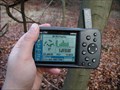
 view gallery view gallery SW2.1 km SW2.1 km
|   N50° E009° N50° E009°
in Confluence Spots A confluence point near the Autobahn. posted by:  BlueGerbil BlueGerbil location: Hessen, Germany date approved: 08/20/2007 last visited: 08/03/2019 |
 view gallery view gallery NW4 km NW4 km
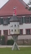
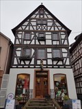
|  Taubenhaus im Kloster Seligenstadt - Hessen, Germany Taubenhaus im Kloster Seligenstadt - Hessen, Germany
in Dovecotes Taubenhaus im Klostergarten posted by: CADS11 location: Hessen, Germany date approved: 08/24/2021 last visited: never |
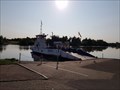 view gallery view galleryNW4.2 km |  Mainfähre Seligenstadt Mainfähre Seligenstadt
in Ferries and Ferry Landings Mainfähre zwischen Seligenstadt und Großwelzheim - Anleger in Seligenstadt posted by: Beorngar location: Hessen, Germany date approved: 07/18/2021 last visited: never |
 view gallery view galleryNW4.3 km |  Zeitleiste Seligenstadt - 815 bis 1977 - Seligenstadt, Hessen, Germany Zeitleiste Seligenstadt - 815 bis 1977 - Seligenstadt, Hessen, Germany
in Timelines Zeitleiste mit 19 Schritten der Stadtgeschichte Seligenstadt - Timeline with 19 steps of city history for Seligenstadt posted by: Beorngar location: Hessen, Germany date approved: 02/02/2019 last visited: never |
 view gallery view galleryNW4.3 km |  Stadtapotheke Seligenstadt - Hessen, Germany Stadtapotheke Seligenstadt - Hessen, Germany
in Independent Pharmacies Stadtapotheke am Marktplatz von Seligenstadt - Stadtapotheke at the market square of Seligenstadt posted by: Beorngar location: Hessen, Germany date approved: 01/27/2019 last visited: never |
 view gallery view galleryNW4.3 km |  Polizeistation Seligenstadt - Hessen, Germany Polizeistation Seligenstadt - Hessen, Germany
in Police Stations Polizeistation in Seligenstadt - police station in Seligenstadt posted by: Beorngar location: Hessen, Germany date approved: 01/28/2019 last visited: never |
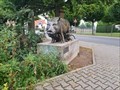 view gallery view galleryNW4.7 km |  Animal group - Seligenstadt, Hessen/Germany Animal group - Seligenstadt, Hessen/Germany
in Figurative Public Sculpture Animal group (mother sow and three piglets) in Seligenstadt by Urban Hüter - Tiergruppe bestehend aus Muttersau und ihren drei Ferkeln in Seligenstadt posted by: Beorngar location: Hessen, Germany date approved: 10/05/2021 last visited: never |
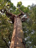 view gallery view gallerySW4.7 km |  Schöne Eiche von Harreshausen - Hessen, Germany Schöne Eiche von Harreshausen - Hessen, Germany
in Exceptional Trees 550 Jahre alte Schöne Eiche von Harreshausen - Mutter aller Pyramideneichen in Europa posted by: Beorngar location: Hessen, Germany date approved: 08/09/2020 last visited: 10/22/2021 |
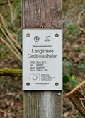
 view gallery view gallery N4.8 km N4.8 km
|  109 m ü. NN - Langensee Großwelzheim — Karlstein am Main, Germany 109 m ü. NN - Langensee Großwelzheim — Karlstein am Main, Germany
in Elevation Signs Altitude and UTM Coordinates at the signpost "Langensee Großwelzheim" in the forest between Karlstein am Main and Kahl am Main posted by: prussel location: Bayern, Germany date approved: 06/15/2021 last visited: never |
 view gallery view galleryN4.8 km |  32U 500097 5544972 - Langensee Großwelzheim — Karlstein am Main, Germany 32U 500097 5544972 - Langensee Großwelzheim — Karlstein am Main, Germany
in Permanent Geographic Coordinates Altitude and UTM Coordinates at the signpost "Langensee Großwelzheim" in the forest between Karlstein am Main and Kahl am Main posted by: prussel location: Bayern, Germany date approved: 06/19/2021 last visited: never |
 view gallery view gallery SE5.8 km SE5.8 km
|  Kreuzweg und Marienkapelle auf dem Kapellenberg — Mainaschaff, Germany Kreuzweg und Marienkapelle auf dem Kapellenberg — Mainaschaff, Germany
in Deutsche Denkmallisten - German Monument Registers Stations of the Cross and Chapel of St. Mary at the Kapellenberg near Mainaschaff posted by: prussel location: Bayern, Germany date approved: 11/14/2012 last visited: 05/29/2020 |
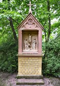
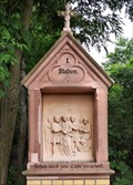 view gallery view gallerySE5.8 km |  Kreuzweg auf dem Kapellenberg — Mainaschaff, Germany Kreuzweg auf dem Kapellenberg — Mainaschaff, Germany
in Outdoor Stations of the Cross Stations of the Cross from 1890 at the Kapellenberg (chapel hill) near Mainaschaff posted by: prussel location: Bayern, Germany date approved: 11/20/2012 last visited: 05/29/2020 |
 view gallery view gallery NE6 km NE6 km
| 299 m ü. NN - Schöne Aussicht — Alzenau, Germany in Elevation Signs Altitude and UTM Coordinates at the signpost "Schöne Aussicht" on the road above the vineyard "Hörsteiner Abtsberg" posted by: prussel location: Bayern, Germany date approved: 06/15/2021 last visited: never |
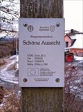 view gallery view galleryNE6 km | 32U 505930 5543873 - Schöne Aussicht — Alzenau, Germany in Permanent Geographic Coordinates Altitude and UTM Coordinates at the signpost "Schöne Aussicht" on the road above the vineyard "Hörsteiner Abtsberg" posted by: prussel location: Bayern, Germany date approved: 06/19/2021 last visited: never |
 view gallery view gallerySE6 km |  Marienkapelle (Lourdeskapelle) — Mainaschaff, Germany Marienkapelle (Lourdeskapelle) — Mainaschaff, Germany
in Waychapels Chapel of St. Mary on the Kapellenberg in Mainaschaff posted by: prussel location: Bayern, Germany date approved: 11/14/2012 last visited: 05/02/2019 |
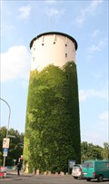 view gallery view galleryN6 km |  Water Tower Kahl am Main, Germany Water Tower Kahl am Main, Germany
in Water Towers The water tower of Kahl am Main is located in the town center. posted by: FBBHaegar location: Hessen, Germany date approved: 08/26/2009 last visited: 01/13/2019 |
 view gallery view gallery E7.4 km E7.4 km
|  Weißes Hellchen — Johannesberg, Germany Weißes Hellchen — Johannesberg, Germany
in Wayside shrines This wayside shrine, the so-called "Weißes Hellchen", is located at a crossroads above Steinberg, a district of the municipality of Johannesberg. posted by: prussel location: Bayern, Germany date approved: 06/15/2021 last visited: never |
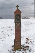 view gallery view galleryE7.4 km | Weißes Hellchen — Johannesberg, Germany in Deutsche Denkmallisten - German Monument Registers Dieser Bildstock, das sogenannte Weiße Hellchen, steht an einer Wegkreuzung oberhalb von Steinberg posted by: prussel location: Bayern, Germany date approved: 06/16/2021 last visited: never |
 view gallery view galleryE7.4 km | 364 m ü. NN - Königsstein Sternberg — Johannesberg, Germany in Elevation Signs Altitude and UTM Coordinates at the signpost "Königsstein Sternberg" on the cycle and hiking trail above Sternberg, a district of the municipality of Johannesberg in the Bavarian district of Aschaffenburg posted by: prussel location: Bayern, Germany date approved: 06/15/2021 last visited: never |
 view gallery view galleryE7.4 km | 32U 508315 5542027 - Königsstein Sternberg — Johannesberg, Germany in Permanent Geographic Coordinates Altitude and UTM Coordinates at the signpost "Königsstein Sternberg" on the cycle and hiking trail above Sternberg, a district of the municipality of Johannesberg in the Bavarian district of Aschaffenburg posted by: prussel location: Bayern, Germany date approved: 06/19/2021 last visited: never |
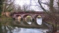 view gallery view gallerySE8.4 km |  Rote Brücke — Aschaffenburg, Germany Rote Brücke — Aschaffenburg, Germany
in Arch Bridges The Rote Brücke (Red Bridge) is a pedestrian bridge in the the Schönbusch Park in Aschaffenburg, one of the earliest landscape gardens in southern Germany posted by: prussel location: Bayern, Germany date approved: 05/30/2013 last visited: never |
 view gallery view gallerySE8.4 km |  Rote Brücke — Aschaffenburg, Germany Rote Brücke — Aschaffenburg, Germany
in Stone Bridges The Rote Brücke (Red Bridge) is a pedestrian bridge in the the Schönbusch Park in Aschaffenburg, one of the earliest landscape gardens in southern Germany posted by: prussel location: Bayern, Germany date approved: 11/22/2012 last visited: 08/28/2014 |
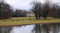 view gallery view gallerySE8.5 km |  Park Schönbusch — Aschaffenburg, Germany Park Schönbusch — Aschaffenburg, Germany
in State/Provincial Parks The Park Schönbusch (also French: Bois-Jolie) in Aschaffenburg is one of the oldest and largest parks in Germany in the style of an English landscape garden posted by: prussel location: Bayern, Germany date approved: 12/03/2012 last visited: 06/21/2016 |
 view gallery view gallerySE8.5 km | Schloss Schönbusch — Aschaffenburg, Germany in Deutsche Denkmallisten - German Monument Registers The Electoral pavilion, called "Schloss Schönbusch" ("Schönbusch Palace") was built from 1778 to 1782 in early classical style and is located in the Park Schönbusch in Aschaffenburg posted by: prussel location: Bayern, Germany date approved: 11/22/2012 last visited: 09/20/2013 |
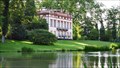 view gallery view gallerySE8.5 km |  Schloß Schönbusch — Aschaffenburg, Germany Schloß Schönbusch — Aschaffenburg, Germany
in Castles The Electoral pavilion, called "Schloß Schönbusch" ("Schönbusch Palace") was built from 1778 to 1782 in early classical style and is located in the Park Schönbusch in Aschaffenburg posted by: prussel location: Bayern, Germany date approved: 12/14/2012 last visited: 09/20/2013 |
|