 view gallery view gallery N1 km N1 km
|   A Tribute to the Royal Canadian Airforce A Tribute to the Royal Canadian Airforce
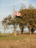
in World War II Memorials / Monuments Near Beny-sur-Mer, a Canadian flag and a monument in a field commemorate the B4 Airfield that the 401st, 411th and 412th Squadrons of the Royal Canadian Air Force used just after the D-
Day Landing. They were based here from 18 June - 7 August 1944. posted by:  flyingandersons flyingandersons location: France date approved: 06/24/2011 last visited: 11/11/2016 |
 view gallery view gallery NW1.8 km NW1.8 km
|  Beny-sur-Mer Canadian War Cemetery - Normandie, France Beny-sur-Mer Canadian War Cemetery - Normandie, France
in Veteran Cemeteries The Beny-sur-Mer Canadian War Cemetery is a cemetery containing predominantly Canadian soldiers killed during the early stages of the Battle of Normandy in the Second World War. posted by: denben location: Normandie, France date approved: 06/01/2011 last visited: 04/19/2023 |
 view gallery view galleryNW1.8 km |  Canadian War Cemetery Beny-sur-Mer - Reviers, France Canadian War Cemetery Beny-sur-Mer - Reviers, France
in Gifts from Other Countries The French people gifted the land to Canada for the burial of the soldiers, sailors and airmen who gave their lives for the freedom of the French people posted by:  PetjeOp PetjeOp location: Normandie, France date approved: 08/24/2022 last visited: 04/19/2023 |
 view gallery view galleryNW1.9 km |  Beny sur Mer. France Beny sur Mer. France
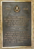
in Canadian Legion Memorials Cairns and Cenotaphs The Cameron Highlanders of Ottawa (33e Groupe-brigade du Canada de l'Armée canadienne au sein de la 4e Division du Canada stationné à Ottawa en Ontario). posted by: lulu_et_compagnie location: Normandie, France date approved: 12/24/2018 last visited: 04/19/2023 |
 view gallery view gallery E2.3 km E2.3 km
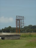
| Funkmeßgerät Stellung Distelfink - Douvres-la-Délivrande, France in World War II Sites This former Luftwaffe Radar Station is located in Douvres-la-Délivrande, France. The site is now home to a museum and bunkers at the site house some of the displays. posted by: Marine Biologist location: Normandie, France date approved: 10/03/2014 last visited: 08/22/2022 |
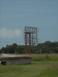 view gallery view galleryE2.3 km |  Funkmeßgerät Stellung Distelfink - Douvres-la-Délivrande, France Funkmeßgerät Stellung Distelfink - Douvres-la-Délivrande, France
in Luftwaffe Radar Ruins This former Luftwaffe Radar Station is located in Douvres-la-Délivrande, France. posted by: Marine Biologist location: Normandie, France date approved: 06/19/2014 last visited: 08/22/2022 |
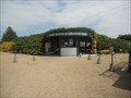 view gallery view galleryE2.3 km |  Musée Radar - Douvres-la-Délivrande, France Musée Radar - Douvres-la-Délivrande, France
in War and Military Museums The Musée Radar is located at the former German radar station just outside Douvres-la- Délivrande, France. The museum demonstrates the important role played by radar during the Second World War. posted by: Marine Biologist location: Normandie, France date approved: 07/20/2014 last visited: 08/22/2022 |
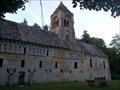 view gallery view gallery SW2.9 km SW2.9 km
|  L' église Saint-Pierre de Thaon, France L' église Saint-Pierre de Thaon, France
in Medieval Churches L'église Saint-Pierre de Thaon est une ancienne église paroissiale construite aux XI e et XII e siècles au fond de la vallée de la Mue.
The St. Peter Church of Thaon is a former parish church built in the eleventh and twelfth centuries. posted by: Alfouine location: Normandie, France date approved: 11/06/2016 last visited: 03/14/2021 |
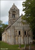 view gallery view gallerySW2.9 km | Église Saint-Pierre / Church of St. Peter (Thaon, Normandy) in Medieval Churches Beautiful Romanesque Church of St. Peter (Église Saint-Pierre) hidden in forests close to Thaon, is one of architectural jewels of medieval architecture in Calvados departement... posted by: Dorcadion Team location: Normandie, France date approved: 02/26/2010 last visited: 03/14/2021 |
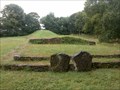
 view gallery view gallery W4.5 km W4.5 km
|  Tumulus de Colombiers-sur-Seulles - France Tumulus de Colombiers-sur-Seulles - France
in Wikipedia Entries Ce tumulus, monument funéraire mesurant 60m de long, a été érigé pendant le Néolithique, la période des premiers agriculteurs
This tumulus, funerary monument measuring 60m long, was erected during the Neolithic period, the period of the first farmers posted by: Alfouine location: Normandie, France date approved: 08/04/2017 last visited: 02/14/2020 |
 view gallery view galleryW4.5 km |  Tumulus de Colombiers-sur-Seulles - France Tumulus de Colombiers-sur-Seulles - France
in News Article Locations Ce tumulus, monument funéraire mesurant 60m de long, a été érigé pendant le Néolithique, la période des premiers agriculteurs
This tumulus, funerary monument measuring 60m long, was erected during the Neolithic period, the period of the first farmers posted by: Alfouine location: Normandie, France date approved: 08/04/2017 last visited: 02/14/2020 |
 view gallery view galleryW4.5 km |  Tumulus de Colombiers-sur-Seulles - France Tumulus de Colombiers-sur-Seulles - France
in Official Local Tourism Attractions Ce tumulus, monument funéraire mesurant 60m de long, a été érigé pendant le Néolithique, la période des premiers agriculteurs
This tumulus, funerary monument measuring 60m long, was erected during the Neolithic period, the period of the first farmers posted by: Alfouine location: Normandie, France date approved: 08/04/2017 last visited: 02/14/2020 |
 view gallery view galleryW4.5 km |  Tumulus de Colombiers-sur-Seulles - France Tumulus de Colombiers-sur-Seulles - France
in Remains of Settlements Ce tumulus, monument funéraire mesurant 60m de long, a été érigé pendant le Néolithique, la période des premiers agriculteurs
This tumulus, funerary monument measuring 60m long, was erected during the Neolithic period, the period of the first farmers posted by: Alfouine location: Normandie, France date approved: 08/04/2017 last visited: 07/25/2022 |
 view gallery view galleryW4.5 km |  Tumulus de Colombiers-sur-Seulles - France Tumulus de Colombiers-sur-Seulles - France
in Cairns Ce tumulus, monument funéraire mesurant 60m de long, a été érigé pendant le Néolithique, la période des premiers agriculteurs
This tumulus, funerary monument measuring 60m long, was erected during the Neolithic period, the period of the first farmers posted by: Alfouine location: Normandie, France date approved: 08/09/2017 last visited: 07/25/2022 |
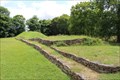 view gallery view galleryW4.5 km |  Tumulus de Colombiers-sur-Seulles - Tumulus de Colombiers-sur-Seulles -
in Megalithic Monuments Dating from 4200 to 4000 BC, the burial mound in Colombiers-sur-Seulles is a 60 metre-long monument. // Rencontre 4200-4000 BC, le tumulus de Colombiers-sur-Seulles est de 60 mètres de long monument. posted by: Trail Blaisers location: Normandie, France date approved: 07/11/2015 last visited: 02/14/2020 |
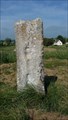
 view gallery view galleryE4.7 km |  Basilique Notre-Dame de la Délivrande Basilique Notre-Dame de la Délivrande
in French Benchmarks [FR]Borne de nivellement située sur la face nord-est de la Basilique Notre-Dame de la Délivrande, à gauche de la porte.[EN]Border of leveling situated on the face north-east of the Basilica Notre-Dame de la Délivrande, to the left of the gate. posted by: 7seven location: Normandie, France date approved: 12/09/2011 last visited: 03/06/2019 |
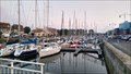 view gallery view galleryNW5.1 km |  Marina Port du Courseulles-sur-Mer - Courseulles-sur-Mer, France Marina Port du Courseulles-sur-Mer - Courseulles-sur-Mer, France
in Marinas The marina of Courseulles-sur-Mr has place for 750 boats spread over two basins posted by: PetjeOp location: Normandie, France date approved: 08/26/2022 last visited: 10/07/2022 |
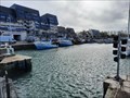 view gallery view galleryN5.3 km |  Le Port de Courseulles-sur-Mer - Manche - Calvados - France Le Port de Courseulles-sur-Mer - Manche - Calvados - France
in Commercial Fishing Ports [EN] Laid out at the mouth of the Seulles river, the port is located on a straight coast, with no anchorages.
[FR] Aménagé sur l’embouchure de la rivière Seulles, le port est situé sur une côte droite, dépourvue de mouillages. posted by: pmaupin location: Normandie, France date approved: 04/14/2021 last visited: 08/22/2022 |
 view gallery view galleryW5.3 km | Menhir des Demoiselles - Colombiers-sur-Seulles - France in Megalithic Monuments Le menhir des Demoiselles ou de la Pierre Debout est un menhir situé au lieu-dit la Pierre.
The menhir of the Demoiselles or the Stone Standing is a menhir located at the place called Pierre. posted by: Alfouine location: Normandie, France date approved: 08/05/2017 last visited: 02/14/2020 |
 view gallery view galleryW5.3 km | Menhir des Demoiselles - Colombiers-sur-Seulles - France in Wikipedia Entries Le menhir des Demoiselles ou de la Pierre Debout est un menhir situé au lieu-dit la Pierre.
The menhir of the Demoiselles or the Stone Standing is a menhir located at the place called Pierre. posted by: Alfouine location: Normandie, France date approved: 08/04/2017 last visited: 02/14/2020 |
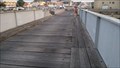 view gallery view galleryN5.3 km |  Plank bridge at the harbour - Courseulles-sur-Mer, France Plank bridge at the harbour - Courseulles-sur-Mer, France
in Plank Roads Small plank bridge close to harbor of Courseulles-sur-Mer posted by: PetjeOp location: Normandie, France date approved: 08/26/2022 last visited: 09/11/2022 |
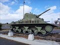 view gallery view galleryN5.3 km |  DD Tank Sherman - Courseulles-sur-Mer, France DD Tank Sherman - Courseulles-sur-Mer, France
in Military Ground Equipment Displays [EN] The Sherman Duplex Drive Bold tank was recovered two kilometers at sea in 1970, then restored before being displayed.
[FR] Le char Sherman Duplex Drive Bold fut récupéré à deux kilomètres en mer en 1970, puis restauré avant d’être exposé. posted by: pmaupin location: Normandie, France date approved: 04/13/2021 last visited: 08/22/2022 |
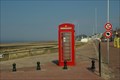 view gallery view galleryN5.3 km |  Red Telephone Box at Juno Beach (Courseulles-sur-Mer, France) Red Telephone Box at Juno Beach (Courseulles-sur-Mer, France)
in Red Telephone Boxes A red telephone box at the extreme westerly point of Juno Beach. posted by: sTeamTraen location: France date approved: 07/10/2010 last visited: 08/22/2022 |
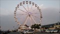 view gallery view galleryN5.3 km |  Feris Wheel - Courseulles-sur-Mer, France Feris Wheel - Courseulles-sur-Mer, France
in Ferris Wheels Ferris wheel at the harbor posted by: PetjeOp location: Normandie, France date approved: 08/22/2022 last visited: 02/24/2023 |
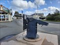 view gallery view galleryN5.3 km |  Canon Anti-Char Allemand KWK 39 - Courseulles-sur-mer, France Canon Anti-Char Allemand KWK 39 - Courseulles-sur-mer, France
in Static Artillery Displays [EN] Improvised defense gun, initially intended for armor armament. (Kampfwagen Kanone).
[FR] Canon de défense improvisé, initialement prévu pour l'armement de blindés. (Kampfwagen Kanone). posted by: pmaupin location: Normandie, France date approved: 05/02/2021 last visited: 08/22/2022 |
|