 view gallery view gallery N3.9 km N3.9 km
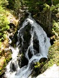
|   Hunt Falls Hunt Falls
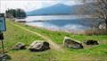
in Waterfalls A beautiful set of falls tucked away along the eastern side of scenic Priest Lake. posted by:  Moun10Bike Moun10Bike location: Idaho date approved: 08/05/2007 last visited: never |
 view gallery view gallery E4.8 km E4.8 km
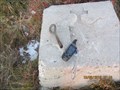
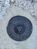
|  Camel's Praire survey bolt, Idaho Camel's Praire survey bolt, Idaho
in Public Land Survey Marks This survey marker was observed while hiking to a geocache. posted by:  Queens Blessing Queens Blessing location: Idaho date approved: 10/28/2012 last visited: 09/02/2013 |
 view gallery view gallery S6.1 km S6.1 km
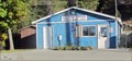
|  Coolin, Idaho 83821 Coolin, Idaho 83821
in U.S. Post Offices Coolin, Idaho is located near beautiful Priest Lake. posted by: Queens Blessing location: Idaho date approved: 10/28/2012 last visited: 11/13/2012 |
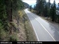
 view gallery view gallery NW11.4 km NW11.4 km
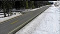
|  Priest Lake Webcam - Priest Lake, ID Priest Lake Webcam - Priest Lake, ID
in Web Cameras This is one of about 150 highway traffic cameras in Idaho which cover every major and a great many of the minor thoroughfares in the state. posted by: T0SHEA location: Idaho date approved: 03/16/2017 last visited: never |
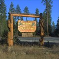 view gallery view gallery SW11.6 km SW11.6 km
|  Welcome to Priest Lake, Idaho Welcome to Priest Lake, Idaho
in Artistic Welcome Signs Priest Lake is located 7 miles east of Washington and 75 miles South of Canada. posted by: Queens Blessing location: Idaho date approved: 10/28/2012 last visited: 06/20/2020 |
 view gallery view gallery NE12.2 km NE12.2 km
|  Mt. Roothaan Mt. Roothaan
in Mountain Summits Mt. Roothaan, elevation 7326 feet posted by: Prying Pandora location: Idaho date approved: 08/24/2009 last visited: 10/23/2005 |
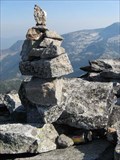 view gallery view galleryNE12.2 km |  Mt. Roothaan Summit Register Mt. Roothaan Summit Register
in Summit Registers Mt. Roothaan, elevation 7326 feet posted by: Prying Pandora location: Idaho date approved: 08/24/2009 last visited: 08/25/2009 |
 view gallery view galleryS19.3 km | Sanca Creek Webcam - Creston, BC in Web Cameras This is a brand new BC Highways webcam we happened to drive by yesterday on a trek up Kootenay Lake. posted by: T0SHEA location: British Columbia, Canada date approved: 10/26/2015 last visited: never |
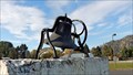 view gallery view galleryNW19.3 km |  Kettle Falls School Bell - Kettle Falls, WA Kettle Falls School Bell - Kettle Falls, WA
in Bells This is the real thing - the bell from Kettle Falls' first school house. posted by: T0SHEA location: Washington date approved: 02/21/2014 last visited: 05/29/2014 |
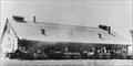 view gallery view galleryNW19.6 km |  The Old Apple Warehouse - Kettle Falls, WA The Old Apple Warehouse - Kettle Falls, WA
in Photos Then and Now The Old Apple Warehouse is one of the oldest remaining buildings in Kettle Falls. It was built well before this was Kettle Falls, back when it was Meyers Falls. posted by: T0SHEA location: Washington date approved: 02/22/2014 last visited: 05/29/2014 |
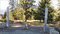 view gallery view galleryNW22.5 km |  Grandview Cemetery - Marcus, WA Grandview Cemetery - Marcus, WA
in Worldwide Cemeteries This cemetery is on the west side of Highway 25, just under a mile northeast of Marcus, WA in Stevens County. posted by: T0SHEA location: Washington date approved: 03/06/2014 last visited: 08/04/2014 |
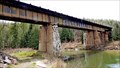 view gallery view gallery SE26.4 km SE26.4 km
|  Railroad Bridge - Ponderay, MT Railroad Bridge - Ponderay, MT
in Railroad Bridges Just east of Highway 2, 8½ miles north of Ponderay, this bridge is easily seen from the highway and even has a little lane leading in to it. posted by: T0SHEA location: Montana date approved: 07/24/2014 last visited: never |
 view gallery view gallerySE26.4 km |  Pack River Fish - Ponderay County, ID Pack River Fish - Ponderay County, ID
in Graffiti Crossing the Pack River north of Sandpoint is a railroad bridge with a nice fish painted on it. posted by: T0SHEA location: Idaho date approved: 01/07/2015 last visited: never |
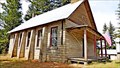
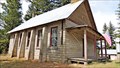 view gallery view galleryE26.7 km |  Elmira School - Elmira, ID Elmira School - Elmira, ID
in Former Schools We spied this little school while travelling between Bonners Ferry and Sandpoint on Highway 95. We're unsure of the original name of the school, though it was likely the Elmira School. The nearest community of any type is Elmira. posted by: T0SHEA location: Idaho date approved: 01/26/2015 last visited: never |
 view gallery view galleryE26.7 km |  Elmira School - Elmira, ID, USA Elmira School - Elmira, ID, USA
in Unoccupied Buildings, Shacks, and Cabins We spied this little school while travelling between Bonners Ferry and Sandpoint on Highway 95. We're unsure of the original name of the school, though it was likely the Elmira School. The nearest community of any type is Elmira. posted by: T0SHEA location: Idaho date approved: 10/30/2017 last visited: never |
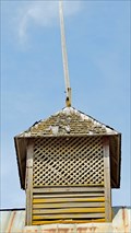 view gallery view galleryE26.7 km |  Elmira School Bell Tower - Elmira, ID Elmira School Bell Tower - Elmira, ID
in Bell Towers We spied this little school while travelling between Bonners Ferry and Sandpoint on Highway 95. We're unsure of the original name of the school, though it was likely the Elmira School. The nearest community of any type is Elmira. posted by: T0SHEA location: Idaho date approved: 01/28/2015 last visited: never |
 view gallery view galleryE26.7 km |  1910 - Elmira School - Elmira, ID 1910 - Elmira School - Elmira, ID
in Dated Buildings and Cornerstones We spied this little school while travelling between Bonners Ferry and Sandpoint on Highway 95. posted by: T0SHEA location: Idaho date approved: 01/27/2015 last visited: never |
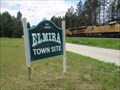 view gallery view galleryE26.9 km |  Union Pacific - Elmira, Idaho Union Pacific - Elmira, Idaho
in Active Rail Locations This active rail location is a perfect spot to watch the trains pass by. Near Hwy. 95/Hwy. 2, cross the railroad tracks on Elmira Road and proceed south about 600 metres. posted by: T0SHEA location: Idaho date approved: 07/05/2018 last visited: never |
 view gallery view galleryN27 km |  Lookout (TO1112) - Boundary county, ID Lookout (TO1112) - Boundary county, ID
in U.S. Benchmarks Lookout Mountain and Lookout Fire Lookout posted by: WaterLily location: Idaho date approved: 10/10/2022 last visited: never |
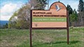
 view gallery view galleryE27.7 km |  McArthur Lake Wildlife Management Area - McArthur, ID McArthur Lake Wildlife Management Area - McArthur, ID
in Wikipedia Entries McArthur Lake Wildlife Management Area was established in 1942 to protect and enhance waterfowl habitat. It is between Sandpoint and Bonners Ferry on Highway 95 in Bonner and Boundary Counties. posted by: T0SHEA location: Idaho date approved: 07/21/2014 last visited: never |
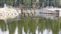 view gallery view galleryE27.7 km |  McArthur Lake Dam - McArthur, ID McArthur Lake Dam - McArthur, ID
in Water Dams McArthur Lake Wildlife Management Area was established in 1942 to protect and enhance waterfowl habitat. It is between Sandpoint and Bonners Ferry on Highway 95 in Bonner and Boundary Counties. posted by: T0SHEA location: Idaho date approved: 07/21/2014 last visited: never |
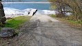 view gallery view galleryE27.7 km |  McArthur Lake Boat Ramp - McArthur, ID McArthur Lake Boat Ramp - McArthur, ID
in Boat Ramps McArthur Lake Wildlife Management Area was established in 1942 to protect and enhance waterfowl habitat. It is between Sandpoint and Bonners Ferry on Highway 95 in Bonner and Boundary Counties. posted by: T0SHEA location: Idaho date approved: 07/22/2014 last visited: never |
 view gallery view galleryE27.7 km |  McArthur Lake Wildlife Management Area - McArthur, Idaho McArthur Lake Wildlife Management Area - McArthur, Idaho
in Public Access Lands McArthur Lake Wildlife Management Area was established in 1942 to protect and enhance waterfowl habitat. It is between Sandpoint and Bonners Ferry on Highway 95 in Bonner and Boundary Counties. posted by: T0SHEA location: Idaho date approved: 12/07/2014 last visited: never |
 view gallery view galleryE27.7 km |  International Selkirk Loop - McArthur Lake Wildlife Management Area, Idaho International Selkirk Loop - McArthur Lake Wildlife Management Area, Idaho
in National Scenic Byways McArthur Lake Wildlife Management Area was established in 1942 to protect and enhance waterfowl habitat. It is between Sandpoint and Bonners Ferry on Highway 95 in Bonner and Boundary Counties. posted by: T0SHEA location: Idaho date approved: 01/26/2015 last visited: never |
 view gallery view galleryE27.7 km |  McArthur Lake Dam - McArthur, ID McArthur Lake Dam - McArthur, ID
in Lucky 7 McArthur Lake Wildlife Management Area was established in 1942 to protect and enhance waterfowl habitat. It is between Sandpoint and Bonners Ferry on Highway 95 in Bonner and Boundary Counties. Tally=14 posted by: T0SHEA location: Idaho date approved: 02/08/2016 last visited: never |
|