 view gallery view gallery N3.2 km N3.2 km
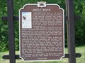
|   Brule-St. Croix Portage Brule-St. Croix Portage
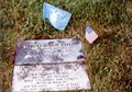
in Wisconsin Historical Markers Brule-St. Croix Portage Marker S of Solon Springs. posted by:  frankhj frankhj location: Wisconsin date approved: 08/07/2008 last visited: 02/25/2015 |
 view gallery view gallery S6 km S6 km
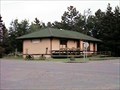
|  SooLine Depot, Gordon, WI SooLine Depot, Gordon, WI
in Train Stations/Depots SooLine Depot in Gordon, WI posted by:  handyman4125 handyman4125 location: Wisconsin date approved: 08/27/2006 last visited: never |
 view gallery view gallery SW9.2 km SW9.2 km
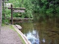
| ") St. Croix National Scenic Riverway St. Croix National Scenic Riverway
in National Parks (U.S.) The dam at the Gordon Flowage Campground is the beginning of the St. Croix National Scenic Riverway. posted by: handyman4125 location: Wisconsin date approved: 08/27/2006 last visited: 04/20/2024 |
  E20 km E20 km
|  Eau Claire River Daytripper Eau Claire River Daytripper
in Canoe/Kayak Trips A local favorite for canoes, kayaks or tubes. posted by: handyman4125 location: Wisconsin date approved: 08/28/2006 last visited: never |
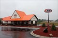 view gallery view galleryS21.6 km |  A&W - Minong, Wisconsin A&W - Minong, Wisconsin
in A + W Restaurants There used to be an A&W restaurant attached to the south end of the gas station at this intersection, but in 2013, they had built their own separate building just across the parking lot to the north. posted by: SageInThyme82 location: Wisconsin date approved: 07/27/2015 last visited: 08/10/2018 |
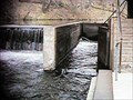 view gallery view galleryE21.6 km |  Eau Claire Lakes lock Eau Claire Lakes lock
in Waterway Locks, Planes and Lifts A small lock located under the bridge at Shore Road posted by: handyman4125 location: Wisconsin date approved: 08/28/2006 last visited: 08/19/2009 |
 view gallery view galleryS21.7 km |  Sportsman's Headquarters - Minong, WI Sportsman's Headquarters - Minong, WI
in Bait Shops All your fishing needs can be found here. posted by: cldisme location: Wisconsin date approved: 10/20/2010 last visited: never |
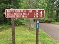
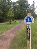
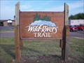 view gallery view galleryS21.7 km |  Wild Rivers Trail Trailhead - Minong, WI Wild Rivers Trail Trailhead - Minong, WI
in Offroad Trails A 104 mile, multi-use trail in northwestern Wisconsin. posted by: cldisme location: Wisconsin date approved: 10/22/2010 last visited: never |
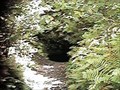 view gallery view galleryE22 km | ") Weyerhaeuser Mine Site Weyerhaeuser Mine Site
in Cave Entrances (Artificial) One of three shafts operated in the early 20th century. posted by: handyman4125 location: Wisconsin date approved: 08/28/2006 last visited: 08/19/2009 |
 view gallery view galleryN26.2 km | Evergreen Park Cottage Sanatorium in Wisconsin Historical Markers Evergreen Park Cottage Sanatorium Marker in Lake Nebagamon. posted by: frankhj location: Wisconsin date approved: 08/07/2008 last visited: 10/09/2009 |
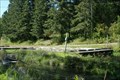
 view gallery view gallery NE29.9 km NE29.9 km
| The Winnebojou Canoe Landing in Canoe/Kayak Trips This waymark is located at the Winneboujou Canoe Landing. posted by: Troutonthebrain location: Wisconsin date approved: 06/14/2012 last visited: 10/11/2021 |
 view gallery view galleryN31.7 km |  Richard I. Bong-Poplar WI Richard I. Bong-Poplar WI
in Medal Of Honor Resting Places World War II Medal of Honor Recipient for action in the air over Borneo and Leyte from October 10 to November 15, 1944. He is buried in Poplar Cemetery, Poplar WI in Plat 1, Block 8, Lot 10. posted by: Don.Morfe location: Wisconsin date approved: 10/09/2017 last visited: 12/19/2021 |
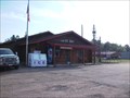
 view gallery view galleryN32.2 km |  Poplar, WI 54864 Poplar, WI 54864
in U.S. Post Offices Post office in small town of Poplar, Wisconsin. posted by: lenron location: Wisconsin date approved: 11/20/2010 last visited: 06/29/2017 |
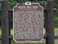 view gallery view galleryN32.3 km | Major "Dick" Bong - "America's Ace of Aces" in Wisconsin Historical Markers Major "Dick" Bong Marker in Poplar. posted by: frankhj location: Wisconsin date approved: 08/07/2008 last visited: 06/29/2017 |
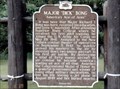 view gallery view galleryN32.3 km |  Major "Dick" Bong "America's Ace of Aces"-Poplar, WI Major "Dick" Bong "America's Ace of Aces"-Poplar, WI
in World War II Memorials / Monuments Poplar, WI was the home town of Dick Bong. In World War II he destroyed 40 enemy aircraft in air combat and become America's leading ace of all time. He was a Medal of Honor Recipient. posted by: Don.Morfe location: Wisconsin date approved: 10/12/2017 last visited: 10/28/2021 |
 view gallery view galleryNE32.3 km |  The Brule Fish Hatchery -- Brule, Wisconsin The Brule Fish Hatchery -- Brule, Wisconsin
in Fish Hatcheries This cache is located at the Brule State Forest Fish Hatchery. posted by: Troutonthebrain location: Wisconsin date approved: 06/05/2012 last visited: 05/28/2021 |
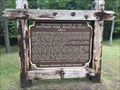
 view gallery view galleryNE33.8 km | Brule River in Wisconsin Historical Markers Brule River Marker in Brule. posted by: frankhj location: Wisconsin date approved: 08/07/2008 last visited: 07/17/2017 |
 view gallery view gallery NW34.9 km NW34.9 km
|  North Country Trail - Beaver Trail - Superior, Wisconsin North Country Trail - Beaver Trail - Superior, Wisconsin
in North Country Trail Trailhead right by the beach at Interfalls Lake. posted by: flyingmoose location: Wisconsin date approved: 09/20/2020 last visited: never |
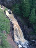 view gallery view galleryNW34.9 km |  Big Manitou Falls Big Manitou Falls
in Waterfalls Highest waterfalls in Wisconsin, 4th highest east of the Rockies posted by: hojpoj location: Wisconsin date approved: 01/12/2011 last visited: 03/07/2019 |
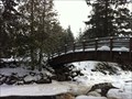 view gallery view galleryNW35.1 km |  Pattison State Park - Wisconsin Pattison State Park - Wisconsin
in State/Provincial Parks Waterfalls, beach, hiking trails, camping, picnicking posted by: hojpoj location: Wisconsin date approved: 01/11/2011 last visited: 03/07/2019 |
 view gallery view galleryNW35.1 km | North Country Trail - Beaver Trail Head - Superior, Wisconsin in North Country Trail Along the trail across from the Big Manitou Falls parking. posted by: flyingmoose location: Wisconsin date approved: 09/20/2020 last visited: never |
 view gallery view galleryNW35.1 km | The Geological History of the Pattison Park - Manitou Falls Area - Superior, Wisconsin in Wisconsin Historical Markers Historical Marker along a trail near the top of Big Manitou Falls. posted by: flyingmoose location: Wisconsin date approved: 09/16/2020 last visited: never |
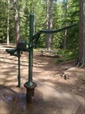 view gallery view galleryN35.6 km |  Hand-Operated Pump at Amnicon Falls southeast of Superior, WI USA Hand-Operated Pump at Amnicon Falls southeast of Superior, WI USA
in Hand Operated Water Pumps A working hand-operated water pump at Amnicon Falls State Park in northern Wisconsin posted by: MountainWoods location: Wisconsin date approved: 07/10/2017 last visited: 07/04/2017 |
 view gallery view gallery SE39.8 km SE39.8 km
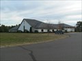
|  Hayward Wesleyan Church - Hayward, WI Hayward Wesleyan Church - Hayward, WI
in Wesleyan Churches Hayward Wesleyan Church's desire is to help folks become fully devoted and fully developing followers of Jesus who are reshaping this community and our world for God’s glory. They are located at 10655 Nyman Ave in Hayward, WI. posted by: onfire4jesus location: Wisconsin date approved: 03/04/2008 last visited: 03/21/2015 |
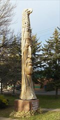 view gallery view gallerySE39.9 km |  #26, Tribute to the Ojibwe, Hayward, WI #26, Tribute to the Ojibwe, Hayward, WI
in Whispering Giant Sculptures This stunning sculpture was made as a tribute to the Ojibwe by Peter Wolf Toth. It is located next to the Carnegie Library on 1st St in Hayward, WI. posted by: onfire4jesus location: Wisconsin date approved: 11/08/2007 last visited: 07/11/2021 |
|