 view gallery view gallery NE0.3 km NE0.3 km
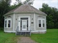
|   The Octagon House The Octagon House
in Octagon Buildings An old house in Sackville, New Brunswick, Canada posted by:  yorelken yorelken location: New Brunswick, Canada date approved: 08/28/2006 last visited: 05/23/2013 |
 view gallery view gallery NW0.6 km NW0.6 km
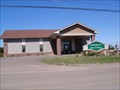
|  Sackville N.B. Kingdom Hall Sackville N.B. Kingdom Hall
in Kingdom Halls of Jehovah's Witnesses Here in Sackville New Brunswick Canada you will be welcomed by Jehovah's Witnesses. posted by:  Acerichard Acerichard location: New Brunswick, Canada date approved: 04/25/2009 last visited: 09/26/2013 |
 view gallery view galleryNE0.8 km |  Sackville, New Brunswick, Canada Sackville, New Brunswick, Canada
in 'You Are Here' Maps This HUGE 'You Are Here' sign is provided by the city of Sackville. posted by:  Queens Blessing Queens Blessing location: New Brunswick, Canada date approved: 09/30/2012 last visited: 09/02/2013 |
 view gallery view gallery SE1.1 km SE1.1 km
|  Boultenhouse Heritage Centre Boultenhouse Heritage Centre
in History Museums Built by Sackville’s most prolific builder of sailing ships, the Boultenhouse Heritage Centre is New Brunswick’s only shipwright-built residence now open as a community museum. posted by: Gaol Keeper location: New Brunswick, Canada date approved: 09/09/2007 last visited: never |
 view gallery view gallery E2.6 km E2.6 km
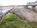
|  Bridge Street Bridge - Sackville, NB Bridge Street Bridge - Sackville, NB
in Orphaned Bridges It was likely the construction of the Trans Canada Highway which but this bridge out of business. posted by: T0SHEA location: New Brunswick, Canada date approved: 01/01/2019 last visited: never |
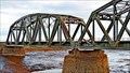 view gallery view galleryE2.6 km |  Canadian National Railways Bridge - Sackville, New Brunswick Canadian National Railways Bridge - Sackville, New Brunswick
in Railroad Bridges Crossing the Tantramar River just south of Sackville, this is a Canadian National Railways bridge. posted by: T0SHEA location: New Brunswick, Canada date approved: 01/13/2019 last visited: 07/04/2019 |
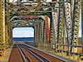 view gallery view galleryE2.6 km |  Canadian National Railways Bridge - Sackville, NB Canadian National Railways Bridge - Sackville, NB
in Truss Bridges Crossing the Tantramar River just south of Sackville, this is a Canadian National Railways bridge. posted by: T0SHEA location: New Brunswick, Canada date approved: 12/30/2018 last visited: 07/04/2019 |
 view gallery view galleryE2.6 km |  Bridge Street Bridge - 1940 - Sackville, NB Bridge Street Bridge - 1940 - Sackville, NB
in Bridge Date Stones and Plaques It was likely the construction of the Trans Canada Highway which but this bridge out of business. posted by: T0SHEA location: New Brunswick, Canada date approved: 01/07/2019 last visited: never |
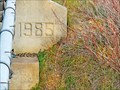 view gallery view galleryE2.6 km |  Canadian National Railways Bridge Abutment - 1985 - Sackville, NB Canadian National Railways Bridge Abutment - 1985 - Sackville, NB
in Dated Architectural Structures Multifarious Crossing the Tantramar River just south of Sackville, this is a Canadian National Railways bridge. posted by: T0SHEA location: New Brunswick, Canada date approved: 12/31/2018 last visited: never |
 view gallery view galleryNE3.5 km | Campbell Carriage Factory Museum in History Museums Re-live the ‘Horse and Buggy Era’ of the Tantramar Marshes. Learn how skilled craftspeople produced customized horse-drawn vehicles. Assorted buggies, tools, and pattern moulds are on display. posted by: Gaol Keeper location: New Brunswick, Canada date approved: 09/09/2007 last visited: 07/04/2019 |
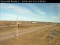 view gallery view galleryE4.8 km |  Route 2 Sackville Highway Webcam - Sackville, NB Route 2 Sackville Highway Webcam - Sackville, NB
in Web Cameras The province of New Brunswick operates a network of highway webcams throughout the province to aid motorists in avoiding blizzards, downpours and any other nasty phenomena Mother Nature may have up her sleeve. posted by: T0SHEA location: New Brunswick, Canada date approved: 04/28/2015 last visited: 08/08/2017 |
 view gallery view gallerySE7.7 km |  Fort Beausejour - Fort Cumberland - Aulac, New Brunswick Fort Beausejour - Fort Cumberland - Aulac, New Brunswick
in UK Historical Markers Fort Beauséjour - Fort Cumberland National Historic Site of Canada, is a star-shaped late 18th- and early 19th-century military fortification built by the French in 1751 and captured by the British in 1755. posted by: Weathervane location: New Brunswick, Canada date approved: 05/11/2022 last visited: never |
 view gallery view gallerySE7.7 km |  Fort Beauséjour - Fort Cumberland - Aulac, New Brunswick Fort Beauséjour - Fort Cumberland - Aulac, New Brunswick
in Historic Forts Fort Beauséjour - Fort Cumberland National Historic Site of Canada, is a star-shaped late 18th- and early 19th-century military fortification situated on the narrow neck of land between Nova Scotia and New Brunswick. posted by: Weathervane location: New Brunswick, Canada date approved: 04/18/2022 last visited: never |
 view gallery view gallerySE7.7 km |  FIRST - Known Pentagonal Five Bastioned fort in North America - Aulac, New Brunswick FIRST - Known Pentagonal Five Bastioned fort in North America - Aulac, New Brunswick
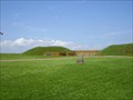
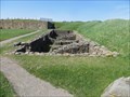
in First of its Kind Fort Beauséjour is one of the first known pentagonal five bastion forts in North-America. While carefully maintained, the Fort is now mostly comprised of remnants and ruins. posted by: Weathervane location: New Brunswick, Canada date approved: 05/13/2020 last visited: never |
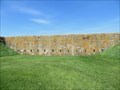 view gallery view gallerySE7.7 km |  Fort Beauséjour – Fort Cumberland - Aulac, New Brunswick Fort Beauséjour – Fort Cumberland - Aulac, New Brunswick
in Atlantic Canada Heritage Properties Fort Beauséjour - Fort Cumberland National Historic Site of Canada is a star-shaped late 18th- and early 19th-century military fortification situated on the narrow neck of land between Nova Scotia and New Brunswick. posted by: Weathervane location: New Brunswick, Canada date approved: 05/13/2020 last visited: 09/04/2021 |
 view gallery view gallerySE7.7 km |  Battle of Fort Cumberland - Aulac, New Brunswick Battle of Fort Cumberland - Aulac, New Brunswick
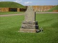
in Political Revolutions The Battle of Fort Cumberland (also known as the Eddy Rebellion) was an attempt by a small number of militia commanded by Jonathan Eddy to bring the American Revolutionary War to Nova Scotia in late 1776. posted by: Weathervane location: New Brunswick, Canada date approved: 05/14/2020 last visited: never |
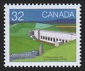 view gallery view gallerySE7.7 km |  Fort Beauséjour, New Brunswick, Canada Fort Beauséjour, New Brunswick, Canada
in Philatelic Photographs Fort Beauséjour, later renamed Fort Cumberland, and located on the border between New Brunswick and Nova Scotia, saw action in two eighteenth-century conflicts. posted by: hykesj location: New Brunswick, Canada date approved: 02/09/2019 last visited: 09/04/2021 |
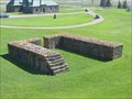
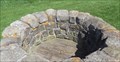 view gallery view gallerySE7.7 km |  Draw Well - Fort Beauséjour - Fort Cumberland - Aulac, New Brunswick Draw Well - Fort Beauséjour - Fort Cumberland - Aulac, New Brunswick
in Draw Wells This draw well was dug by the French Forces of New France in 1751 during the construction of Fort Beauséjour.. posted by: Weathervane location: New Brunswick, Canada date approved: 05/14/2020 last visited: never |
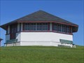 view gallery view gallerySE7.7 km | Picnic Shelter / Pavilion - Forts Beauséjour / Cumberland - Aulac, New Brunswick in Atlantic Canada Heritage Properties The Picnic Shelter Pavilion at Fort Beauséjour National Historic Site of Canada, is a simple, octagonal, wood structure with a hipped roof. It is designed in a traditional style and built with natural building materials. posted by: Weathervane location: Nova Scotia, Canada date approved: 05/13/2020 last visited: never |
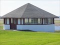 view gallery view gallerySE7.7 km | Picnic Shelter / Pavilion - Forts Beauséjour / Cumberland - Aulac, New Brunswick in Octagon Buildings The Picnic Shelter Pavilion at Fort Beauséjour National Historic Site of Canada, is a simple, octagonal, wood structure with a hipped roof. It is designed in a traditional style and built with natural building materials. posted by: Weathervane location: New Brunswick, Canada date approved: 05/14/2020 last visited: never |
 view gallery view gallerySE7.7 km |  CNHS - Fort Beausejour - Fort Cumberland, Aulac, NB. CNHS - Fort Beausejour - Fort Cumberland, Aulac, NB.
in Canadian National Historic Sites Located outside the town of Aulac in New Brunswick at the Nova Scotia border. posted by: JDandDD location: New Brunswick, Canada date approved: 07/04/2008 last visited: 05/30/2014 |
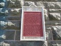
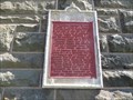 view gallery view gallerySE7.7 km | Fort Beauséjour – Fort Cumberland - Aulac, NB in Canadian National Historic Sites Le texte de cette plaque, reliée au Fort Beauséjour – Fort Cumberland, érigé en 1750-1751, est en français seulement. The text of this plaque, relative to Fort Beauséjour – Fort Cumberland, built in 1750-51, is in French only. posted by: Weathervane location: New Brunswick, Canada date approved: 06/14/2014 last visited: 06/16/2014 |
 view gallery view gallerySE7.7 km | CNHS - Thomas Dixson in Canadian National Historic Sites On front wall of Fort Beausejour Interpretive Centre, Aulac, New Brunswick. posted by: JDandDD location: New Brunswick, Canada date approved: 07/05/2008 last visited: 07/19/2013 |
 view gallery view gallerySE7.7 km |  Changing Times - Une Époque Mouvementée - Aulac, New-Brunswick Changing Times - Une Époque Mouvementée - Aulac, New-Brunswick
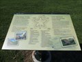
in Signs of History This plaque, titled "Changing Times", is located on the grounds of Fort-Beauséjour - Fort Cumberland. Cette plaque, intitulée, Une époque mouvementée, est située sur le terrain du Fort-Beauséjour - Fort-Cumberland. posted by: Weathervane location: Nova Scotia, Canada date approved: 03/07/2022 last visited: never |
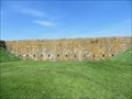
 view gallery view gallerySE7.9 km |  Fort Beausejour - Fort Cumberland - Aulac, New Brunswick Fort Beausejour - Fort Cumberland - Aulac, New Brunswick
in Preserved Architectural Remnants and Ruins The French built Fort Beauséjour in 1750-1751 to advance their interests in the disputed borderlands of Acadia. It was seized by the British in 1755 and renamed Fort Cumberland. The British abandoned the fort in 1835. posted by: Weathervane location: New Brunswick, Canada date approved: 05/15/2020 last visited: 09/04/2021 |
|